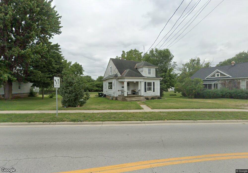
1010 W Main St van Wert, OH 45891
Estimated Value: $122,000 - $137,000
2
Beds
1
Bath
1,416
Sq Ft
$92/Sq Ft
Est. Value
About This Home
This home is located at 1010 W Main St, van Wert, OH 45891 and is currently estimated at $130,935, approximately $92 per square foot. 1010 W Main St is a home located in Van Wert County with nearby schools including Van Wert Early Childhood Center, Van Wert High School, and Lifelinks Community School.
Ownership History
Date
Name
Owned For
Owner Type
Purchase Details
Closed on
Dec 28, 2023
Sold by
Barbara A Welch Living Trust
Bought by
Baw46 Llc
Current Estimated Value
Purchase Details
Closed on
Sep 4, 2013
Sold by
Fannie Mae
Bought by
Barbara Ann Welch Revocable Living Trust
Purchase Details
Closed on
Jun 13, 2013
Sold by
Dunn Jason and Dunn Rachel
Bought by
Federal National Mortgage Association
Purchase Details
Closed on
Aug 29, 2006
Sold by
Coyne Dana L and Harter Stephanie A
Bought by
Dunn Jason and Dunn Rachel
Home Financials for this Owner
Home Financials are based on the most recent Mortgage that was taken out on this home.
Original Mortgage
$56,500
Interest Rate
6.88%
Mortgage Type
New Conventional
Create a Home Valuation Report for This Property
The Home Valuation Report is an in-depth analysis detailing your home's value as well as a comparison with similar homes in the area
Home Values in the Area
Average Home Value in this Area
Purchase History
| Date | Buyer | Sale Price | Title Company |
|---|---|---|---|
| Baw46 Llc | -- | None Listed On Document | |
| Barbara Ann Welch Revocable Living Trust | $19,000 | Intitle Agency | |
| Federal National Mortgage Association | $16,000 | None Available | |
| Dunn Jason | $56,500 | None Available |
Source: Public Records
Mortgage History
| Date | Status | Borrower | Loan Amount |
|---|---|---|---|
| Previous Owner | Dunn Jason | $56,500 |
Source: Public Records
Tax History Compared to Growth
Tax History
| Year | Tax Paid | Tax Assessment Tax Assessment Total Assessment is a certain percentage of the fair market value that is determined by local assessors to be the total taxable value of land and additions on the property. | Land | Improvement |
|---|---|---|---|---|
| 2024 | $1,035 | $29,580 | $4,100 | $25,480 |
| 2023 | $1,035 | $29,580 | $4,100 | $25,480 |
| 2022 | $835 | $20,620 | $3,040 | $17,580 |
| 2021 | $814 | $20,620 | $3,040 | $17,580 |
| 2020 | $812 | $20,620 | $3,040 | $17,580 |
| 2019 | $698 | $17,310 | $3,040 | $14,270 |
| 2018 | $679 | $17,310 | $3,040 | $14,270 |
| 2017 | $645 | $17,310 | $3,040 | $14,270 |
| 2016 | $568 | $15,470 | $3,040 | $12,430 |
| 2015 | $568 | $15,470 | $3,040 | $12,430 |
| 2014 | $562 | $15,470 | $3,040 | $12,430 |
| 2013 | $605 | $15,470 | $3,040 | $12,430 |
Source: Public Records
Map
Nearby Homes
- 1028 Westchester Ct
- 1055 Westchester Ct
- 927 Woodland Ave
- 218 Burt St
- 729 George St
- 706 Woodland Ave
- 1006 Hughes St
- 1213 David St
- 603 Pewterboy Ave
- 829 Allingham St
- 510 Euclid Ave
- 1006 Kear Rd
- 902 Kear Rd
- 736 Leeson Ave
- 331 North St
- 228 W 2nd St
- 304 Anderson Ave
- 1421 Krendl Dr
- 522 South Ave
- 214 N Jefferson St