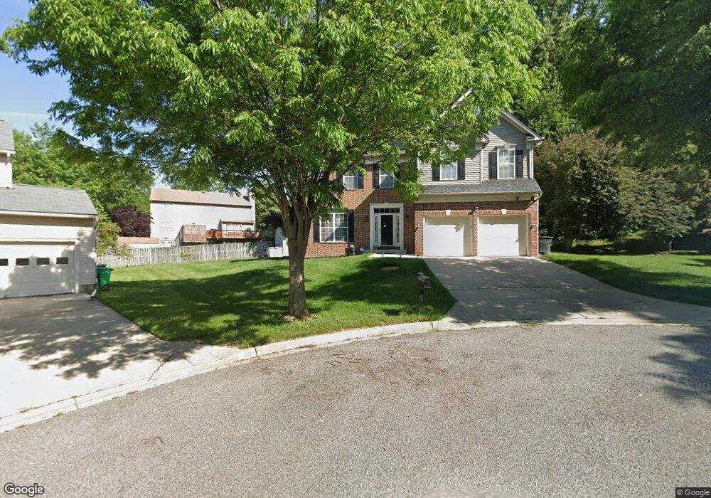
10101 Cutters Row Ct Clinton, MD 20735
Estimated Value: $533,000 - $574,000
--
Bed
3
Baths
2,394
Sq Ft
$233/Sq Ft
Est. Value
About This Home
This home is located at 10101 Cutters Row Ct, Clinton, MD 20735 and is currently estimated at $556,991, approximately $232 per square foot. 10101 Cutters Row Ct is a home located in Prince George's County with nearby schools including Waldon Woods Elementary School, Stephen Decatur Middle School, and Surrattsville High School.
Ownership History
Date
Name
Owned For
Owner Type
Purchase Details
Closed on
Mar 12, 2003
Sold by
Freeman Kenneth H
Bought by
Freeman Kenneth H
Current Estimated Value
Purchase Details
Closed on
Apr 18, 2000
Sold by
First National Bnk Of Chicago Trs
Bought by
Freeman Kenneth H and Freeman Sandra M
Purchase Details
Closed on
Sep 28, 1999
Sold by
Garner George and Garner Linda P
Bought by
First National Bnk Of Chicago Trs and Hcfn 3Rd Flr
Purchase Details
Closed on
Oct 8, 1993
Sold by
Lovell Regency Homes
Bought by
Garner George
Home Financials for this Owner
Home Financials are based on the most recent Mortgage that was taken out on this home.
Original Mortgage
$156,251
Interest Rate
6.9%
Create a Home Valuation Report for This Property
The Home Valuation Report is an in-depth analysis detailing your home's value as well as a comparison with similar homes in the area
Home Values in the Area
Average Home Value in this Area
Purchase History
| Date | Buyer | Sale Price | Title Company |
|---|---|---|---|
| Freeman Kenneth H | -- | -- | |
| Freeman Kenneth H | $208,140 | -- | |
| First National Bnk Of Chicago Trs | $175,000 | -- | |
| Garner George | $212,773 | -- |
Source: Public Records
Mortgage History
| Date | Status | Borrower | Loan Amount |
|---|---|---|---|
| Open | Garner George | $249,000 | |
| Previous Owner | Garner George | $156,251 |
Source: Public Records
Tax History Compared to Growth
Tax History
| Year | Tax Paid | Tax Assessment Tax Assessment Total Assessment is a certain percentage of the fair market value that is determined by local assessors to be the total taxable value of land and additions on the property. | Land | Improvement |
|---|---|---|---|---|
| 2025 | $6,002 | $503,400 | $126,500 | $376,900 |
| 2024 | $6,002 | $464,100 | $0 | $0 |
| 2023 | $5,710 | $424,800 | $0 | $0 |
| 2022 | $5,367 | $385,500 | $101,500 | $284,000 |
| 2021 | $5,167 | $374,800 | $0 | $0 |
| 2020 | $5,086 | $364,100 | $0 | $0 |
| 2019 | $4,977 | $353,400 | $100,700 | $252,700 |
| 2018 | $4,791 | $332,367 | $0 | $0 |
| 2017 | $4,635 | $311,333 | $0 | $0 |
| 2016 | -- | $290,300 | $0 | $0 |
| 2015 | $4,574 | $288,300 | $0 | $0 |
| 2014 | $4,574 | $286,300 | $0 | $0 |
Source: Public Records
Map
Nearby Homes
- 7002 Killarney St
- 7001 Killarney St
- 9917 Raintree Way
- 10106 Goldfinch Ct
- 7300 Roxy Run Unit 6
- 7304 Roxy Run Unit 8
- 7308 Roxy Run Unit 10
- Cedar Pointe
- 10306 Serenade Ct
- Kennedy Plan at Cedar Pointe
- 6911 Simmons Ln
- 8403 Black Willow Ct
- 9923 Quiet Brook Ln
- 7200 White Bud Ct
- 6706 Surratts Rd
- 10309 Brandywine Rd
- 10003 Armor Ct
- 6204 Armor Dr
- 10523 Moores Ln
- 6118 Hellen Lee Dr
- 10100 Cutters Row Ct
- 10103 Cutters Row Ct
- 10104 Mount Auburn Dr
- 10106 Mount Auburn Dr
- 10102 Mount Auburn Dr
- 10108 Mount Auburn Dr
- 10102 Cutters Row Ct
- 7108 Redwood Branch Ct
- 10100 Mount Auburn Dr
- 7106 Redwood Branch Ct
- 7104 Redwood Branch Ct
- 10104 Cutters Row Ct
- 7100 Huckleberry Ct
- 10110 Mount Auburn Dr
- 7101 Huckleberry Ct
- 7008 Chain Fern Ct
- 7102 Huckleberry Ct
- 10101 Mount Auburn Dr
- 7103 Huckleberry Ct
- 7202 Redwood Branch Ct