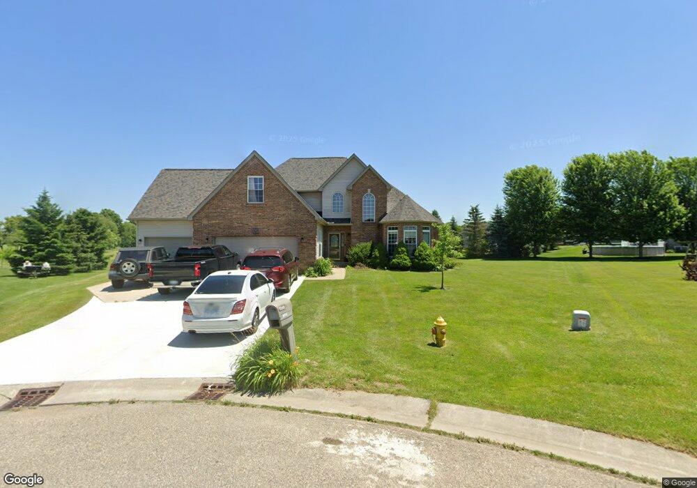
10102 N Hunt Ct Davison, MI 48423
Estimated Value: $337,108 - $378,000
Studio
1
Bath
2,241
Sq Ft
$160/Sq Ft
Est. Value
About This Home
This home is located at 10102 N Hunt Ct, Davison, MI 48423 and is currently estimated at $357,777, approximately $159 per square foot. 10102 N Hunt Ct is a home located in Genesee County with nearby schools including Thomson Elementary School, Hill Elementary School, and Siple Elementary School.
Ownership History
Date
Name
Owned For
Owner Type
Purchase Details
Closed on
Sep 16, 2005
Sold by
Arnold Gary W and Arnold Debra J
Bought by
Hartman William L
Current Estimated Value
Purchase Details
Closed on
Nov 12, 2003
Sold by
Richardson Robert and Richardson Stacy A
Bought by
Arnold Gary W and Arnold Debra J
Purchase Details
Closed on
Aug 3, 2001
Sold by
Hunt Farm Estates
Bought by
Richardson Robert and Richardson Stacy A
Create a Home Valuation Report for This Property
The Home Valuation Report is an in-depth analysis detailing your home's value as well as a comparison with similar homes in the area
Home Values in the Area
Average Home Value in this Area
Purchase History
| Date | Buyer | Sale Price | Title Company |
|---|---|---|---|
| Hartman William L | $220,900 | Sargents Title Company | |
| Arnold Gary W | $39,900 | Cislo Title Company | |
| Richardson Robert | $38,900 | Lawyers Title Insurance Corp |
Source: Public Records
Tax History
| Year | Tax Paid | Tax Assessment Tax Assessment Total Assessment is a certain percentage of the fair market value that is determined by local assessors to be the total taxable value of land and additions on the property. | Land | Improvement |
|---|---|---|---|---|
| 2025 | $4,583 | $176,900 | $0 | $0 |
| 2024 | $1,362 | $172,700 | $0 | $0 |
| 2023 | $1,300 | $164,200 | $0 | $0 |
| 2022 | $4,076 | $140,300 | $0 | $0 |
| 2021 | $4,040 | $122,600 | $0 | $0 |
| 2020 | $1,189 | $120,100 | $0 | $0 |
| 2019 | $1,156 | $120,000 | $0 | $0 |
| 2018 | $2,203 | $114,800 | $0 | $0 |
| 2017 | $3,184 | $114,800 | $0 | $0 |
| 2016 | $3,121 | $109,000 | $0 | $0 |
| 2015 | $2,670 | $94,100 | $0 | $0 |
| 2014 | $1,030 | $95,700 | $0 | $0 |
| 2012 | -- | $89,000 | $89,000 | $0 |
Source: Public Records
Map
Nearby Homes
- 10190 Hunt Dr
- Vacant Deere Dr
- 3370 Cherry Blossom Ct Unit 7
- 9805 E Richfield Rd
- 3365 Meadow Ridge Ct
- 3369 Meadow Ridge Ct
- 3367 Meadow Ridge Ct
- 9440 E Potter Rd
- 0 N State Rd Unit 20261007508
- 3371 Meadowridge Ct Unit 107
- 3371 Meadowridge Ct
- 490 Harrison Dr
- 7040 N Oak Rd
- 2239 Baltimore Ln
- 2323 Baltimore
- 7120 N Oak Rd
- 7250 N Oak Rd
- 00 Richfield Rd E
- 2367 Baltimore
- 7165 Donegal
- 10101 N Hunt Ct
- 10119 Hunt Dr
- 10127 Hunt Dr
- 10111 Hunt Dr
- 10103 Hunt Dr
- 10086 N Hunt Ct
- 10086 N Hunt Ct Unit O
- 10135 Hunt Dr
- 10093 N Hunt Ct
- 10095 Hunt Dr
- 10085 N Hunt Ct
- 10143 Hunt Dr
- 10078 N Hunt Ct Unit Bldg-Unit
- 10078 N Hunt Ct
- 10087 Hunt Dr
- 10077 N Hunt Ct
- 10124 Hunt Dr
- 000 Deere
- 10151 Hunt Dr
- 10079 Hunt Dr
Your Personal Tour Guide
Ask me questions while you tour the home.