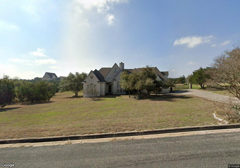
10108 Baxter Ln Austin, TX 78736
Estimated Value: $989,000 - $1,928,000
--
Bed
3
Baths
3,329
Sq Ft
$391/Sq Ft
Est. Value
About This Home
This home is located at 10108 Baxter Ln, Austin, TX 78736 and is currently estimated at $1,300,804, approximately $390 per square foot. 10108 Baxter Ln is a home located in Travis County with nearby schools including Baldwin Elementary School, Small Middle School, and James Bowie High School.
Ownership History
Date
Name
Owned For
Owner Type
Purchase Details
Closed on
Apr 5, 2000
Sold by
Norma Michael Wood Family Trust
Bought by
Greenblatt Seth A
Current Estimated Value
Home Financials for this Owner
Home Financials are based on the most recent Mortgage that was taken out on this home.
Original Mortgage
$324,000
Outstanding Balance
$115,148
Interest Rate
8.75%
Estimated Equity
$1,185,656
Purchase Details
Closed on
Sep 9, 1999
Sold by
Wood Norma M
Bought by
Norma Michael Wood Family Trust and First State Bank Of Gainesville Texas
Purchase Details
Closed on
Apr 1, 1999
Sold by
Harren Steve G
Bought by
Wood Norma M
Create a Home Valuation Report for This Property
The Home Valuation Report is an in-depth analysis detailing your home's value as well as a comparison with similar homes in the area
Home Values in the Area
Average Home Value in this Area
Purchase History
| Date | Buyer | Sale Price | Title Company |
|---|---|---|---|
| Greenblatt Seth A | -- | -- | |
| Norma Michael Wood Family Trust | -- | -- | |
| Wood Norma M | -- | Stewart Title |
Source: Public Records
Mortgage History
| Date | Status | Borrower | Loan Amount |
|---|---|---|---|
| Open | Greenblatt Seth A | $324,000 |
Source: Public Records
Tax History Compared to Growth
Tax History
| Year | Tax Paid | Tax Assessment Tax Assessment Total Assessment is a certain percentage of the fair market value that is determined by local assessors to be the total taxable value of land and additions on the property. | Land | Improvement |
|---|---|---|---|---|
| 2025 | $7,510 | $634,910 | -- | -- |
| 2023 | $6,074 | $524,719 | $0 | $0 |
| 2022 | $7,428 | $477,017 | $0 | $0 |
| 2021 | $7,375 | $433,652 | $104,300 | $329,352 |
| 2020 | $8,189 | $459,582 | $104,300 | $355,282 |
| 2018 | $8,473 | $453,293 | $104,300 | $348,993 |
| 2017 | $8,429 | $446,359 | $104,300 | $342,059 |
| 2016 | $8,588 | $454,805 | $104,300 | $350,505 |
| 2015 | $7,546 | $454,200 | $104,300 | $354,727 |
| 2014 | $7,546 | $412,909 | $0 | $0 |
Source: Public Records
Map
Nearby Homes
- 9909 Oliver Dr
- 10133 Oliver Dr
- 9614 Bronzewood Dr
- TBD Highway 290
- 10204 Oak Grove Cir
- 9301 Elm Grove Cir
- 9908 Derecho Bend
- 9805 Ledgestone Terrace
- 9926 Ledgestone Terrace
- 9504 Flintrock Cir
- 9114 U S 290
- 11420 Rim Rock Trail
- 8004 Kuhn Dr
- 8100 Kuhn Dr
- 9513 Morninghill Dr
- 11601 Morningsun Dr
- 9207 Zyle Rd
- 9438 Circle Dr
- 33400 Brooks Ranch Rd
- 11205 Oak Branch Dr
- 10104 Baxter Ln
- 10111 Baxter Ln
- 10203 Baxter Ln
- 10107 Baxter Ln
- 10807 Baxter Cir
- 10801 Baxter Cir
- 10101 Baxter Ln
- 2 Baxter Ln
- 14 Baxter Ln
- 3 Baxter Ln
- 10806 Baxter Cir
- 10013 Baxter Ln
- 10301 Highway 290 W
- 10003 Baxter Ln
- 10200 E Highway 290
- 10200 Highway 290 W
- 10200 W Highway 290
- 10605 Oliver Cir
- 10604 Oliver Cir
- 10015 Baxter Ln