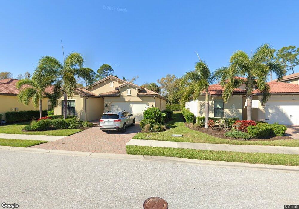
1011 Bluffwood Dr Nokomis, FL 34275
Estimated Value: $449,260 - $511,000
3
Beds
2
Baths
1,806
Sq Ft
$270/Sq Ft
Est. Value
About This Home
This home is located at 1011 Bluffwood Dr, Nokomis, FL 34275 and is currently estimated at $488,315, approximately $270 per square foot. 1011 Bluffwood Dr is a home with nearby schools including Laurel Nokomis School, Venice High School, and Island Village Montessori School.
Ownership History
Date
Name
Owned For
Owner Type
Purchase Details
Closed on
Jan 10, 2024
Sold by
Perez Frank M and Perez Ides
Bought by
Frank And Ides Perez Family Trust and Perez
Current Estimated Value
Purchase Details
Closed on
Dec 16, 2016
Sold by
D R Horton Inc
Bought by
Perez Frank M and Perez Ides
Home Financials for this Owner
Home Financials are based on the most recent Mortgage that was taken out on this home.
Original Mortgage
$143,875
Interest Rate
2.37%
Mortgage Type
Adjustable Rate Mortgage/ARM
Create a Home Valuation Report for This Property
The Home Valuation Report is an in-depth analysis detailing your home's value as well as a comparison with similar homes in the area
Home Values in the Area
Average Home Value in this Area
Purchase History
| Date | Buyer | Sale Price | Title Company |
|---|---|---|---|
| Frank And Ides Perez Family Trust | $100 | None Listed On Document | |
| Perez Frank M | $287,800 | Dhi Title Of Florida Inc |
Source: Public Records
Mortgage History
| Date | Status | Borrower | Loan Amount |
|---|---|---|---|
| Previous Owner | Perez Frank M | $143,875 |
Source: Public Records
Tax History Compared to Growth
Tax History
| Year | Tax Paid | Tax Assessment Tax Assessment Total Assessment is a certain percentage of the fair market value that is determined by local assessors to be the total taxable value of land and additions on the property. | Land | Improvement |
|---|---|---|---|---|
| 2024 | $4,235 | $390,232 | -- | -- |
| 2023 | $4,235 | $378,866 | $0 | $0 |
| 2022 | $4,120 | $367,831 | $0 | $0 |
| 2021 | $3,473 | $262,800 | $78,000 | $184,800 |
| 2020 | $3,403 | $252,400 | $81,700 | $170,700 |
| 2019 | $3,339 | $250,900 | $81,700 | $169,200 |
| 2018 | $3,035 | $227,800 | $57,500 | $170,300 |
| 2017 | $3,226 | $238,900 | $42,600 | $196,300 |
| 2016 | $563 | $41,700 | $41,700 | $0 |
Source: Public Records
Map
Nearby Homes
- 1015 Bluffwood Dr
- 1050 Bluffwood Dr
- 1048 Bradberry Dr
- 1069 Bluffwood Dr
- 700 Forest St
- 320 Browns Rd
- 500 Church St
- 5860 Ocean Isle Dr
- 601 Hamlin St
- 604 King St
- 237 Browns Rd
- 17015 Coral Key Dr
- 751 Arabian Cir
- 94 Anne Bonny Cir
- 5921 Sailor Coast Way
- 1112 Sunset Ave
- 0 Old Trail Unit MFRA4661203
- 1661 Lugano Cir
- 41 Lafitte Dr
- 809 Garland Ave
- 1007 Bluffwood Dr
- 1021 Bluffwood Dr
- 637 Fantail Way
- 1022 Bluffwood Dr
- 1025 Bluffwood Dr
- 744 Church St
- 1026 Bluffwood Dr
- 641 Fantail Way
- 1029 Bluffwood Dr
- 1030 Bluffwood Dr
- 748 Church St
- 1019 Bradberry Dr
- 645 Fantail Way
- 740 Church St
- 1034 Bluffwood Dr
- 1033 Bluffwood Dr
- 1023 Bradberry Dr
- 742 Church St
- 738 Church St
- 1027 Bradberry Dr