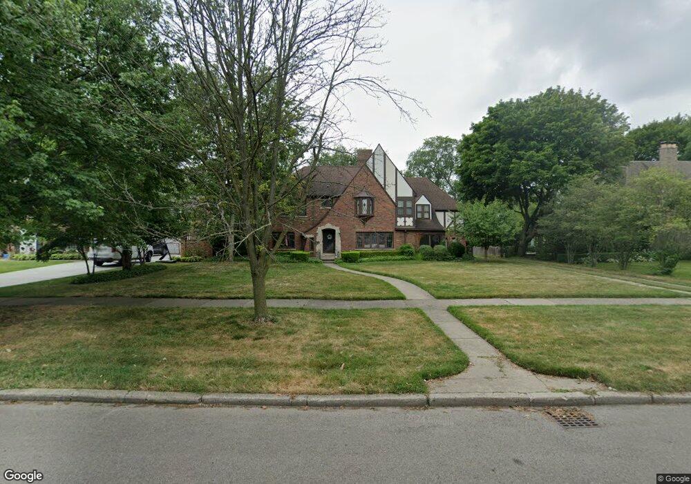
1011 Buckingham Rd Grosse Pointe Park, MI 48230
Estimated Value: $784,714 - $910,000
5
Beds
4
Baths
3,469
Sq Ft
$242/Sq Ft
Est. Value
About This Home
This home is located at 1011 Buckingham Rd, Grosse Pointe Park, MI 48230 and is currently estimated at $840,179, approximately $242 per square foot. 1011 Buckingham Rd is a home located in Wayne County with nearby schools including George Defer Elementary School, Pierce Middle School, and Grosse Pointe South High School.
Ownership History
Date
Name
Owned For
Owner Type
Purchase Details
Closed on
Mar 26, 2019
Sold by
Holloway Aaron T and Holloway Lynnette E
Bought by
Holloway Aaron T and Holloway Lynnette E
Current Estimated Value
Purchase Details
Closed on
Nov 23, 2011
Sold by
Volonino Stella N
Bought by
Volonino Stella N and Volonino Paul A
Purchase Details
Closed on
Apr 22, 2009
Sold by
Gay Owen
Bought by
Holloway Aaron
Create a Home Valuation Report for This Property
The Home Valuation Report is an in-depth analysis detailing your home's value as well as a comparison with similar homes in the area
Home Values in the Area
Average Home Value in this Area
Purchase History
| Date | Buyer | Sale Price | Title Company |
|---|---|---|---|
| Holloway Aaron T | -- | None Available | |
| Volonino Stella N | -- | None Available | |
| Holloway Aaron | $250,000 | Greco |
Source: Public Records
Tax History
| Year | Tax Paid | Tax Assessment Tax Assessment Total Assessment is a certain percentage of the fair market value that is determined by local assessors to be the total taxable value of land and additions on the property. | Land | Improvement |
|---|---|---|---|---|
| 2025 | $6,367 | $401,500 | $0 | $0 |
| 2024 | $6,129 | $373,700 | $0 | $0 |
| 2023 | $5,853 | $343,500 | $0 | $0 |
| 2022 | $5,560 | $316,400 | $0 | $0 |
| 2021 | $10,964 | $297,700 | $0 | $0 |
| 2019 | $11,283 | $275,900 | $0 | $0 |
| 2018 | $5,302 | $238,700 | $0 | $0 |
| 2017 | $11,734 | $165,000 | $0 | $0 |
| 2016 | $11,012 | $246,700 | $0 | $0 |
| 2015 | $19,840 | $227,900 | $0 | $0 |
| 2013 | $19,220 | $195,300 | $0 | $0 |
| 2012 | $5,291 | $204,900 | $81,800 | $123,100 |
Source: Public Records
Map
Nearby Homes
- 943 Harcourt Rd Unit 45
- 1206 Balfour St
- 74 Pointe Park Place Unit 311
- 1048 Lakepointe St Unit A
- 32 Pointe Park Place Unit 31
- 26 Pointe Park Place Unit 303
- 815 Harcourt Rd Unit 2
- 1083 Lakepointe St
- 814 Harcourt Rd Unit 816
- 796 Harcourt Rd Unit 98
- 1254 Beaconsfield Ave
- 1338 Somerset Ave
- 1239 Maryland St
- 1328 Lakepointe St
- 2568 Alter Rd
- 2140 Alter Rd
- 801 Park Ln
- 908 Manistique St
- 1030 Bishop Rd
- 709 Ashland St
- 1015 Buckingham Rd
- 1009 Buckingham Rd
- 1016 Berkshire Rd
- 1008 Berkshire Rd
- 1028 Berkshire Rd
- 1007 Buckingham Rd
- 1017 Buckingham Rd
- 1006 Berkshire Rd
- 1012 Buckingham Rd
- 1036 Berkshire Rd
- 1014 Buckingham Rd
- 1019 Buckingham Rd
- 1005 Buckingham Rd
- 1016 Buckingham Rd
- 1008 Buckingham Rd
- 1004 Berkshire Rd
- 1040 Berkshire Rd
- 1003 Buckingham Rd
- 1006 Buckingham Rd
- 1043 Devonshire Rd
Your Personal Tour Guide
Ask me questions while you tour the home.