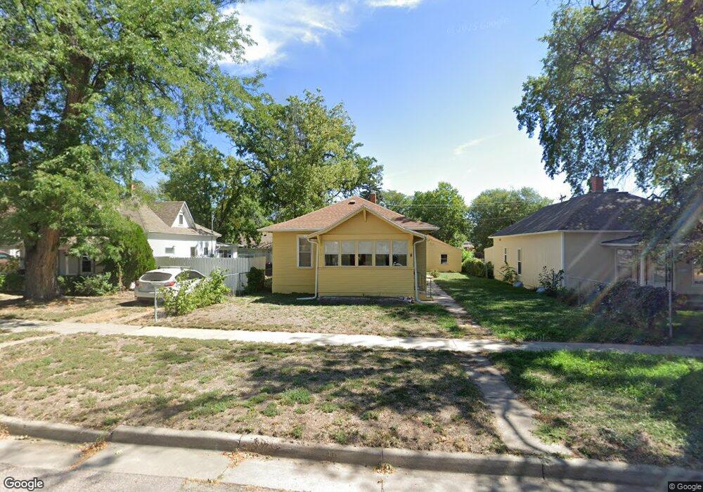
1011 Cheyenne Ave Alliance, NE 69301
Estimated Value: $114,191 - $126,000
2
Beds
1
Bath
988
Sq Ft
$120/Sq Ft
Est. Value
About This Home
This home is located at 1011 Cheyenne Ave, Alliance, NE 69301 and is currently estimated at $118,798, approximately $120 per square foot. 1011 Cheyenne Ave is a home located in Box Butte County with nearby schools including Alliance High School, St. Agnes Academy, and Immanuel Evangelical Lutheran School.
Ownership History
Date
Name
Owned For
Owner Type
Purchase Details
Closed on
Jul 7, 2013
Sold by
Gribble Craig J and Gribble Christina I
Bought by
Phillips Denice A
Current Estimated Value
Home Financials for this Owner
Home Financials are based on the most recent Mortgage that was taken out on this home.
Original Mortgage
$42,500
Outstanding Balance
$30,995
Interest Rate
3.99%
Mortgage Type
Purchase Money Mortgage
Estimated Equity
$87,803
Create a Home Valuation Report for This Property
The Home Valuation Report is an in-depth analysis detailing your home's value as well as a comparison with similar homes in the area
Home Values in the Area
Average Home Value in this Area
Purchase History
| Date | Buyer | Sale Price | Title Company |
|---|---|---|---|
| Phillips Denice A | -- | Kunzman Title |
Source: Public Records
Mortgage History
| Date | Status | Borrower | Loan Amount |
|---|---|---|---|
| Open | Phillips Denice A | $42,500 |
Source: Public Records
Tax History Compared to Growth
Tax History
| Year | Tax Paid | Tax Assessment Tax Assessment Total Assessment is a certain percentage of the fair market value that is determined by local assessors to be the total taxable value of land and additions on the property. | Land | Improvement |
|---|---|---|---|---|
| 2024 | $1,081 | $86,305 | $7,000 | $79,305 |
| 2023 | $1,484 | $86,305 | $7,000 | $79,305 |
| 2022 | $1,349 | $74,075 | $6,300 | $67,775 |
| 2021 | $1,365 | $74,075 | $6,300 | $67,775 |
| 2020 | $1,362 | $74,075 | $6,300 | $67,775 |
| 2019 | $1,330 | $74,075 | $6,300 | $67,775 |
| 2018 | $1,323 | $74,075 | $6,300 | $67,775 |
| 2017 | $1,181 | $63,640 | $4,550 | $59,090 |
| 2016 | $1,168 | $63,640 | $4,550 | $59,090 |
| 2015 | $1,089 | $60,315 | $4,550 | $55,765 |
| 2014 | $1,089 | $64,405 | $4,550 | $59,855 |
Source: Public Records
Map
Nearby Homes
- 1019 Laramie Ave
- 904 Laramie Ave
- 924 Big Horn Ave
- 907 Toluca Ave
- 1239 Toluca Ave
- 911 Emerson Ave
- 719 Toluca Ave
- 936 Platte Ave
- 621 Emerson Ave
- 819 Black Hills Ave
- 1004 Missouri Ave
- 615 Sweetwater Ave
- 917 Missouri Ave
- 420 Laramie Ave
- 1021 Dakota Ave
- 316 Big Horn Ave
- 613 Mississippi Ave
- 1120 Potash Ave
- 20th St Emerson Ave To Colorado Ave
- 667 E 9th St
- 1015 Cheyenne Ave
- 1007 Cheyenne Ave
- 1019 Cheyenne Ave
- 1003 Cheyenne Ave
- 214 W 10th St
- 214 W 10th St
- 1023 Cheyenne Ave
- 1012 Laramie Ave
- 1016 Laramie Ave
- 1008 Laramie Ave
- 1018 Laramie Ave
- 1004 Laramie Ave
- 1027 Cheyenne Ave
- 1004 Cheyenne Ave
- 935 Cheyenne Ave
- 1020 Laramie Ave
- 1012 Cheyenne Ave
- 1020 Cheyenne Ave Unit 1024
- 1016 Cheyenne Ave
- 1115 Cheyenne Ave