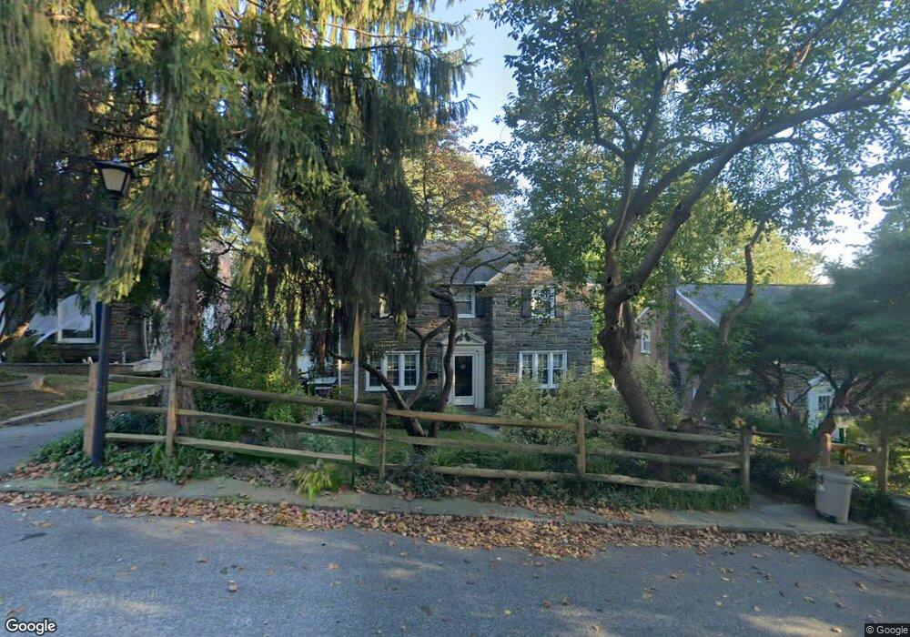
1011 Crest Rd Wynnewood, PA 19096
Estimated Value: $664,000 - $752,000
4
Beds
2
Baths
2,230
Sq Ft
$318/Sq Ft
Est. Value
About This Home
This home is located at 1011 Crest Rd, Wynnewood, PA 19096 and is currently estimated at $709,570, approximately $318 per square foot. 1011 Crest Rd is a home located in Delaware County with nearby schools including Chatham Park Elementary School, Haverford Middle School, and Haverford Senior High School.
Ownership History
Date
Name
Owned For
Owner Type
Purchase Details
Closed on
Jul 13, 2015
Sold by
Mazer Michael J and Mazer Debbie S
Bought by
Mazer Debbie S
Current Estimated Value
Purchase Details
Closed on
Apr 12, 1996
Sold by
Blumenthal Mitchell and Blumenthal Edan
Bought by
Mazer Michael J and Mazer Debbie S
Home Financials for this Owner
Home Financials are based on the most recent Mortgage that was taken out on this home.
Original Mortgage
$153,600
Outstanding Balance
$8,289
Interest Rate
8.85%
Mortgage Type
Purchase Money Mortgage
Estimated Equity
$701,281
Create a Home Valuation Report for This Property
The Home Valuation Report is an in-depth analysis detailing your home's value as well as a comparison with similar homes in the area
Home Values in the Area
Average Home Value in this Area
Purchase History
| Date | Buyer | Sale Price | Title Company |
|---|---|---|---|
| Mazer Debbie S | -- | None Available | |
| Mazer Michael J | $192,000 | -- |
Source: Public Records
Mortgage History
| Date | Status | Borrower | Loan Amount |
|---|---|---|---|
| Open | Mazer Michael J | $153,600 |
Source: Public Records
Tax History Compared to Growth
Tax History
| Year | Tax Paid | Tax Assessment Tax Assessment Total Assessment is a certain percentage of the fair market value that is determined by local assessors to be the total taxable value of land and additions on the property. | Land | Improvement |
|---|---|---|---|---|
| 2025 | $9,548 | $371,320 | $98,340 | $272,980 |
| 2024 | $9,548 | $371,320 | $98,340 | $272,980 |
| 2023 | $9,276 | $371,320 | $98,340 | $272,980 |
| 2022 | $9,060 | $371,320 | $98,340 | $272,980 |
| 2021 | $14,759 | $371,320 | $98,340 | $272,980 |
| 2020 | $8,660 | $186,320 | $49,800 | $136,520 |
| 2019 | $8,500 | $186,320 | $49,800 | $136,520 |
| 2018 | $8,354 | $186,320 | $0 | $0 |
| 2017 | $8,177 | $186,320 | $0 | $0 |
| 2016 | $1,023 | $186,320 | $0 | $0 |
| 2015 | $1,023 | $186,320 | $0 | $0 |
| 2014 | $1,023 | $186,320 | $0 | $0 |
Source: Public Records
Map
Nearby Homes
- 212 Henley Rd
- 758 Lawson Ave
- 755 Lawson Ave
- 1455 Braddock Ln
- 109 Overbrook Pkwy
- 243 Rock Glen Rd
- 633 E Manoa Rd
- 26 Henley Rd
- 611 Penfield Ave
- 978 Township Line Rd
- 1504 Sheffield Ln
- 628 Lawson Ave
- 249 Haverford Rd
- 529 Covington Rd
- 1406 Greywall Ln
- 501 E Manoa Rd
- 520 Twin Oaks Dr
- 304 Earlington Rd
- 7661 Overbrook Ave
- 1319 Remington Rd