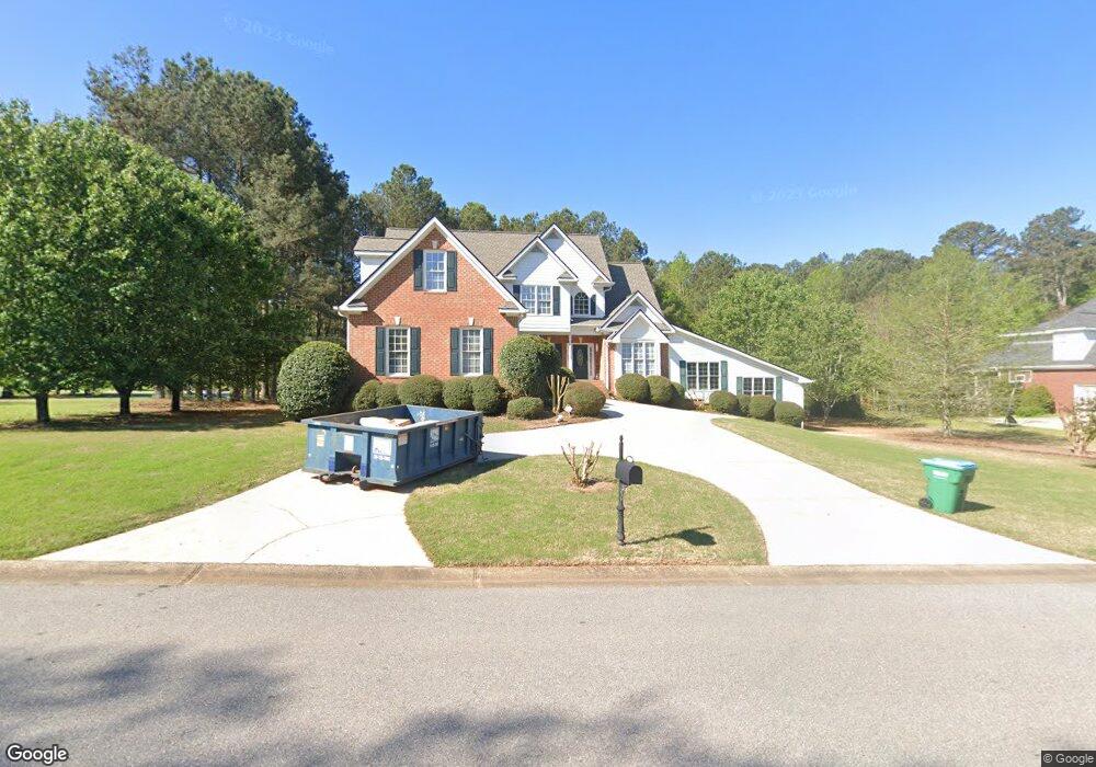
1011 Harrowford Rd S Statham, GA 30666
Estimated Value: $503,683 - $592,000
3
Beds
2
Baths
2,254
Sq Ft
$246/Sq Ft
Est. Value
About This Home
This home is located at 1011 Harrowford Rd S, Statham, GA 30666 and is currently estimated at $553,671, approximately $245 per square foot. 1011 Harrowford Rd S is a home located in Oconee County with nearby schools including Rocky Branch Elementary School, Malcom Bridge Middle School, and North Oconee High School.
Ownership History
Date
Name
Owned For
Owner Type
Purchase Details
Closed on
Apr 20, 2018
Sold by
Johnson William F
Bought by
Frey Julie and Frey Joel
Current Estimated Value
Home Financials for this Owner
Home Financials are based on the most recent Mortgage that was taken out on this home.
Original Mortgage
$278,856
Outstanding Balance
$239,867
Interest Rate
4.45%
Mortgage Type
FHA
Estimated Equity
$313,804
Purchase Details
Closed on
Nov 14, 2002
Sold by
H & H General Contractors Inc
Bought by
Johnson William F
Purchase Details
Closed on
Feb 28, 2002
Sold by
Garrett Betty S
Bought by
H & H General Contractors Inc
Create a Home Valuation Report for This Property
The Home Valuation Report is an in-depth analysis detailing your home's value as well as a comparison with similar homes in the area
Home Values in the Area
Average Home Value in this Area
Purchase History
| Date | Buyer | Sale Price | Title Company |
|---|---|---|---|
| Frey Julie | $284,000 | -- | |
| Johnson William F | $200,000 | -- | |
| H & H General Contractors Inc | $210,000 | -- |
Source: Public Records
Mortgage History
| Date | Status | Borrower | Loan Amount |
|---|---|---|---|
| Open | Frey Julie | $278,856 |
Source: Public Records
Tax History Compared to Growth
Tax History
| Year | Tax Paid | Tax Assessment Tax Assessment Total Assessment is a certain percentage of the fair market value that is determined by local assessors to be the total taxable value of land and additions on the property. | Land | Improvement |
|---|---|---|---|---|
| 2024 | $3,582 | $192,001 | $30,000 | $162,001 |
| 2023 | $3,582 | $175,738 | $22,000 | $153,738 |
| 2022 | $3,330 | $155,724 | $22,000 | $133,724 |
| 2021 | $3,059 | $132,777 | $22,000 | $110,777 |
| 2020 | $2,611 | $113,236 | $18,000 | $95,236 |
| 2019 | $2,618 | $111,559 | $18,000 | $93,559 |
| 2016 | $2,223 | $94,504 | $18,000 | $76,504 |
| 2015 | $2,210 | $93,800 | $18,000 | $75,800 |
| 2014 | $2,197 | $91,178 | $18,000 | $73,178 |
| 2013 | -- | $87,963 | $18,000 | $69,963 |
Source: Public Records
Map
Nearby Homes
- 1080 Ashland Dr
- N/A Hog Mountain Rd
- 1901 Hog Mountain Rd
- 1921 Hog Mountain Rd
- LOT 10 Sikes Rd
- LOT 9 Sikes Rd
- LOT 8 Sikes Rd
- LOT 7 Sikes Rd
- LOT 6 Sikes Rd
- LOT 5 Sikes Rd
- LOT 4 Sikes Rd
- LOT 3 Sikes Rd
- LOT 2 Sikes Rd
- LOT 1 Sikes Rd
- 4611 Monroe Hwy - Hwy 78
- 4611 Monroe Hwy - Hwy 78 Unit PARCEL C
- 1296 Club Estates Rd
- 1471 Sikes Rd
- 1621 Westland Ct
- 1547 Westland Ct
- 1011 Harrowford Dr S
- 1010 Harrowford Rd S
- 1010 Harrowford Dr S
- 1041 Harrowford Rd S
- 1030 Harrowford Rd S
- 1050 Harrowford Rd S
- 1050 Harrowford Dr S
- S Harrowford Dr S
- 1071 Garrett Rd
- 1021 Charles Ct
- 1040 Garrett Rd
- 1100 Garrett Rd
- 1011 Harrowford Rd N
- 1010 Charles Ct
- 1011 Harrowford Dr N
- 1070 Harrowford Rd S
- 1030 Garrett Rd
- 0 Charles Ct Unit 8755773
- 0 Charles Ct Unit 7081559
- 1020 Charles Ct