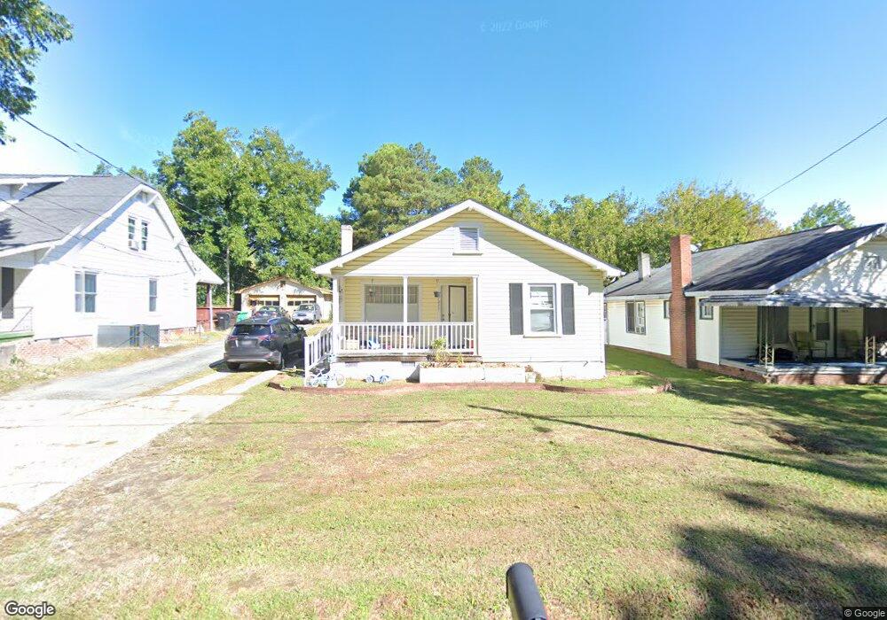
1011 Nathan Hunt Dr High Point, NC 27260
Greater High Point NeighborhoodEstimated Value: $117,000 - $132,000
3
Beds
1
Bath
1,100
Sq Ft
$114/Sq Ft
Est. Value
About This Home
This home is located at 1011 Nathan Hunt Dr, High Point, NC 27260 and is currently estimated at $124,942, approximately $113 per square foot. 1011 Nathan Hunt Dr is a home located in Guilford County with nearby schools including Fairview Elementary School, Ferndale Middle School, and High Point Central High School.
Ownership History
Date
Name
Owned For
Owner Type
Purchase Details
Closed on
Aug 25, 1998
Sold by
Hud
Bought by
Clark Darren R and Clark Linda B
Current Estimated Value
Home Financials for this Owner
Home Financials are based on the most recent Mortgage that was taken out on this home.
Original Mortgage
$37,800
Outstanding Balance
$7,886
Interest Rate
6.92%
Estimated Equity
$117,056
Purchase Details
Closed on
Apr 6, 1998
Sold by
Hodgin Ronald L
Bought by
Hud
Create a Home Valuation Report for This Property
The Home Valuation Report is an in-depth analysis detailing your home's value as well as a comparison with similar homes in the area
Home Values in the Area
Average Home Value in this Area
Purchase History
| Date | Buyer | Sale Price | Title Company |
|---|---|---|---|
| Clark Darren R | -- | -- | |
| Hud | $51,116 | -- |
Source: Public Records
Mortgage History
| Date | Status | Borrower | Loan Amount |
|---|---|---|---|
| Open | Clark Darren R | $37,800 |
Source: Public Records
Tax History Compared to Growth
Tax History
| Year | Tax Paid | Tax Assessment Tax Assessment Total Assessment is a certain percentage of the fair market value that is determined by local assessors to be the total taxable value of land and additions on the property. | Land | Improvement |
|---|---|---|---|---|
| 2025 | $832 | $60,400 | $11,000 | $49,400 |
| 2024 | $832 | $60,400 | $11,000 | $49,400 |
| 2023 | $832 | $60,400 | $11,000 | $49,400 |
| 2022 | $814 | $60,400 | $11,000 | $49,400 |
| 2021 | $580 | $42,100 | $8,800 | $33,300 |
| 2020 | $580 | $42,100 | $8,800 | $33,300 |
| 2019 | $580 | $42,100 | $0 | $0 |
| 2018 | $577 | $42,100 | $0 | $0 |
| 2017 | $577 | $42,100 | $0 | $0 |
| 2016 | $522 | $37,200 | $0 | $0 |
| 2015 | $525 | $37,200 | $0 | $0 |
| 2014 | $533 | $37,200 | $0 | $0 |
Source: Public Records
Map
Nearby Homes
- 1605 Mossbrook Cir
- 1907 Apex Place
- 1222 Carter St
- 650 Wesley Dr
- 640 Wesley Dr
- 430 New St
- 2317 Purdy Ave
- 511 Hines St
- 507 Hines St
- 811 Worth St
- 901 Richland St
- 1423 E Commerce Ave
- 1908 Leonard Ave
- 1010 Grace St
- 901 Hickory Chapel Rd
- 1035 Asheboro St
- 709 Habersham Rd
- 504 Meredith St
- 607 Martha Place
- 312 Model Farm Rd
- 1013 Nathan Hunt Dr
- 1009 Nathan Hunt Dr
- 1017 Nathan Hunt Dr
- 2404 Friends Ave
- 2400 Friends Ave
- 1019 Nathan Hunt Dr
- 2312 Friends Ave
- 2408 Friends Ave
- 1008 Nathan Hunt Dr
- 1014 Nathan Hunt Dr
- 1004 Nathan Hunt Dr
- 1605 Brentwood St
- 2306 Friends Ave
- 1021 Nathan Hunt Dr
- 1615 Brentwood St
- 1002 Nathan Hunt Dr
- 1023 Nathan Hunt Dr
- 2500 Friends Ave
- 1001 Garrison St
- 1020 Nathan Hunt Dr