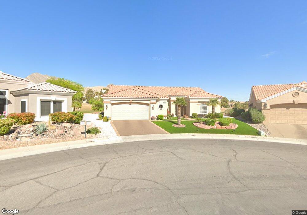
10116 Folsom Dr Las Vegas, NV 89134
Sun City Summerlin NeighborhoodEstimated Value: $691,000 - $796,000
3
Beds
2
Baths
2,176
Sq Ft
$342/Sq Ft
Est. Value
About This Home
This home is located at 10116 Folsom Dr, Las Vegas, NV 89134 and is currently estimated at $744,881, approximately $342 per square foot. 10116 Folsom Dr is a home located in Clark County with nearby schools including William Lummis Elementary School, Ernest Becker Middle School, and Palo Verde High School.
Ownership History
Date
Name
Owned For
Owner Type
Purchase Details
Closed on
Aug 2, 2021
Sold by
Mansfield Cox Joe
Bought by
Joe And Jane Cox Living Trust
Current Estimated Value
Purchase Details
Closed on
Dec 8, 2004
Sold by
Cox Joe M and Cox Jane F
Bought by
Cox Joe and Cox Jane
Purchase Details
Closed on
Mar 1, 1997
Sold by
Del Webb Communities Inc
Bought by
Cox Joe M and Cox Jane F
Create a Home Valuation Report for This Property
The Home Valuation Report is an in-depth analysis detailing your home's value as well as a comparison with similar homes in the area
Home Values in the Area
Average Home Value in this Area
Purchase History
| Date | Buyer | Sale Price | Title Company |
|---|---|---|---|
| Joe And Jane Cox Living Trust | -- | -- | |
| Cox Joe | -- | -- | |
| Cox Joe M | $254,500 | First American Title Co |
Source: Public Records
Tax History Compared to Growth
Tax History
| Year | Tax Paid | Tax Assessment Tax Assessment Total Assessment is a certain percentage of the fair market value that is determined by local assessors to be the total taxable value of land and additions on the property. | Land | Improvement |
|---|---|---|---|---|
| 2025 | $3,853 | $158,949 | $76,160 | $82,789 |
| 2024 | $3,853 | $158,949 | $76,160 | $82,789 |
| 2023 | $3,853 | $145,137 | $66,500 | $78,637 |
| 2022 | $3,741 | $129,949 | $57,750 | $72,199 |
| 2021 | $3,632 | $119,217 | $50,505 | $68,712 |
| 2020 | $3,523 | $118,747 | $50,505 | $68,242 |
| 2019 | $3,420 | $112,539 | $45,273 | $67,266 |
| 2018 | $3,321 | $105,866 | $40,845 | $65,021 |
| 2017 | $3,144 | $103,631 | $38,430 | $65,201 |
| 2016 | $3,144 | $97,918 | $32,515 | $65,403 |
| 2015 | $3,138 | $93,880 | $29,295 | $64,585 |
| 2014 | $3,046 | $89,302 | $27,283 | $62,019 |
Source: Public Records
Map
Nearby Homes
- 10100 Folsom Dr
- 3020 Ripon Dr
- 3033 Bonnie Rock Dr
- 3001 Swan Hill Dr
- 3032 Highland Falls Dr
- 10020 Villa Ridge Dr
- 10009 Hemet Dr
- 10012 Bundella Dr
- 9929 Hemet Dr
- 10017 Bundella Dr Unit 34
- 9948 Bundella Dr
- 9905 Hemet Dr
- 9916 Villa Ridge Dr
- 2801 Byron Dr
- 10044 Woodhouse Dr
- 9816 Gerald Ct
- 2725 Byron Dr
- 9908 Bundella Dr
- 3028 Treesdale Dr
- Mike Plan at Parkside
- 3029 Swan Hill Dr
- 10112 Folsom Dr
- 3025 Swan Hill Dr
- 10108 Folsom Dr
- 3028 Swan Hill Dr
- 3021 Swan Hill Dr
- 3021 Swan Hill Dr
- 10104 Folsom Dr
- 3024 Swan Hill Dr Unit 32
- 3033 Ripon Dr
- 3020 Swan Hill Dr
- 3017 Swan Hill Dr
- 3029 Ripon Dr
- 3016 Swan Hill Dr
- 10040 Folsom Dr
- 3013 Swan Hill Dr
- 3025 Ripon Dr
- 3012 Swan Hill Dr
- 3028 Highland Falls Dr
- 3024 Highland Falls Dr