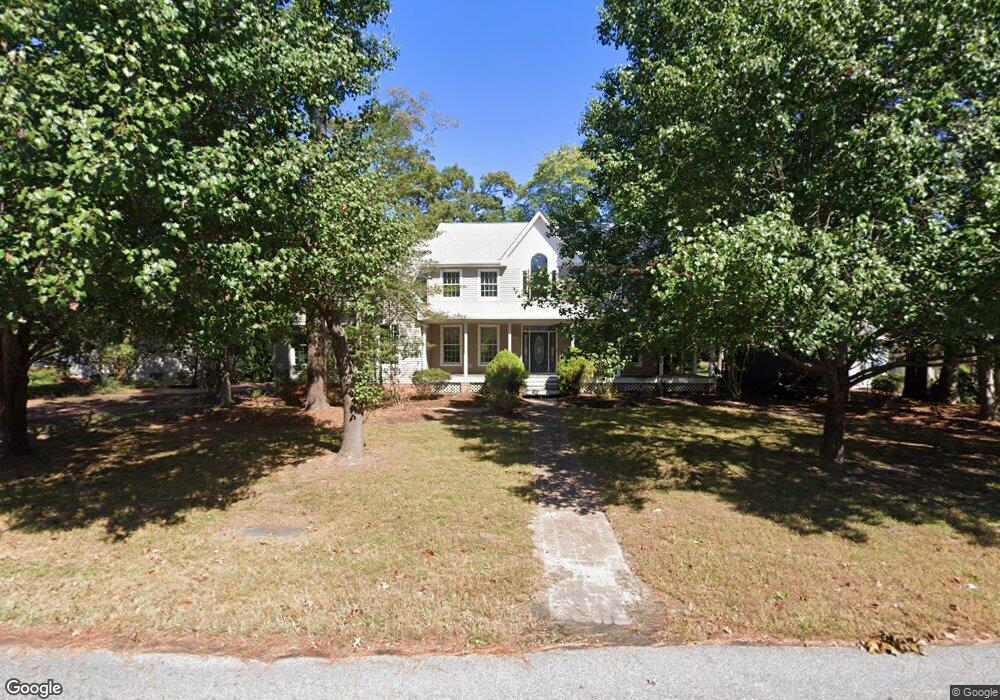
10120 Queens Cir Ocean City, MD 21842
West Ocean City NeighborhoodEstimated Value: $708,000 - $862,000
4
Beds
4
Baths
3,610
Sq Ft
$213/Sq Ft
Est. Value
About This Home
This home is located at 10120 Queens Cir, Ocean City, MD 21842 and is currently estimated at $767,926, approximately $212 per square foot. 10120 Queens Cir is a home located in Worcester County with nearby schools including Ocean City Elementary School, Stephen Decatur Middle School, and Berlin Intermediate School.
Ownership History
Date
Name
Owned For
Owner Type
Purchase Details
Closed on
Oct 30, 2007
Sold by
Mark Morgen
Bought by
Mark Morgen
Current Estimated Value
Purchase Details
Closed on
Sep 28, 2006
Sold by
Mark Morgen
Bought by
Mark Morgen
Purchase Details
Closed on
Oct 7, 1996
Sold by
Kelly Joseph J
Bought by
Mark Morgen
Purchase Details
Closed on
May 16, 1996
Sold by
Lewis Lloyd B and Lewis Gail T
Bought by
Kelly Joseph J
Create a Home Valuation Report for This Property
The Home Valuation Report is an in-depth analysis detailing your home's value as well as a comparison with similar homes in the area
Home Values in the Area
Average Home Value in this Area
Purchase History
| Date | Buyer | Sale Price | Title Company |
|---|---|---|---|
| Mark Morgen | -- | -- | |
| Mark Morgen | -- | -- | |
| Mark Morgen | $63,900 | -- | |
| Kelly Joseph J | $59,000 | -- |
Source: Public Records
Mortgage History
| Date | Status | Borrower | Loan Amount |
|---|---|---|---|
| Closed | Kelly Joseph J | -- |
Source: Public Records
Tax History Compared to Growth
Tax History
| Year | Tax Paid | Tax Assessment Tax Assessment Total Assessment is a certain percentage of the fair market value that is determined by local assessors to be the total taxable value of land and additions on the property. | Land | Improvement |
|---|---|---|---|---|
| 2025 | $5,281 | $593,500 | $139,200 | $454,300 |
| 2024 | $5,281 | $554,300 | $0 | $0 |
| 2023 | $4,930 | $515,100 | $0 | $0 |
| 2022 | $4,534 | $475,900 | $139,200 | $336,700 |
| 2021 | $4,522 | $472,533 | $0 | $0 |
| 2020 | $4,490 | $469,167 | $0 | $0 |
| 2019 | $4,458 | $465,800 | $139,200 | $326,600 |
| 2018 | $4,299 | $455,967 | $0 | $0 |
| 2017 | $4,225 | $446,133 | $0 | $0 |
| 2016 | $4,256 | $436,300 | $0 | $0 |
| 2015 | $3,523 | $436,300 | $0 | $0 |
| 2014 | $3,523 | $436,300 | $0 | $0 |
Source: Public Records
Map
Nearby Homes
- 10127 Queens Cir
- 10133 Queens Cir
- 10103 Queens Cir
- 10204 Golf Course Rd
- 10288 Broken Sound Blvd
- 12716 Whisper Trace Dr
- 10305 Turtle Ct
- 10117 Keyser Point Rd
- 0 Keyser Point Rd Unit MDWO118100
- 12927 Center Dr
- 13005 Bowline Ln Unit 1
- 13005 UNIT 5 Bowline Ln Unit 5
- 10013 Bonita Dr
- 10050 Golf Course Rd Unit 6
- 13008 Bowline Ln Unit 2
- 12910 Lake Ave
- 12506 Sea Buoy Ct
- 12602 Balte Rd
- 12907 Sand Bar Ln Unit 2
- 12907 Sand Bar Ln
- 10124 Queens Cir
- 10116 Queens Cir
- Lot 47 Queens Cir
- 10128 Queens Cir
- 10123 Queens Cir
- 10125 Queens Cir
- 10114 Queens Cir
- 10121 Queens Cir
- 10132 Queens Cir
- 10112 Queens Cir
- 10117 Queens Cir
- 9 Rusty Anchor Common
- 8 Rusty Anchor Common
- 7 Rusty Anchor Common
- 6 Rusty Anchor Common
- 5 Rusty Anchor Common
- 4 Rusty Anchor Common
- 30 Rusty Anchor Common
- 3 Rusty Anchor Common
- 29 Rusty Anchor Common