
Seller's Agent in 2026
Tracy Stone
Coldwell Banker Chesapeake Real Estate Company
(443) 480-0610
40 Total Sales
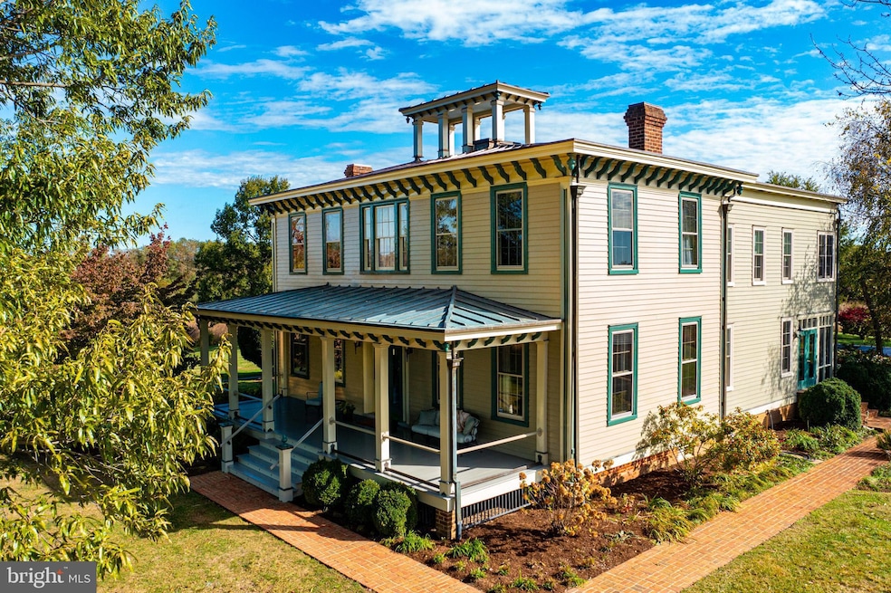
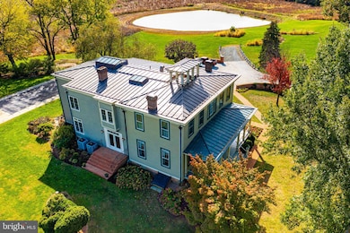
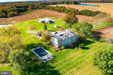
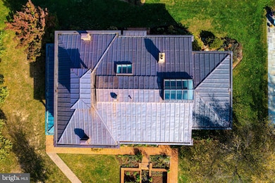
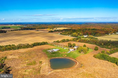
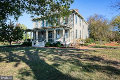
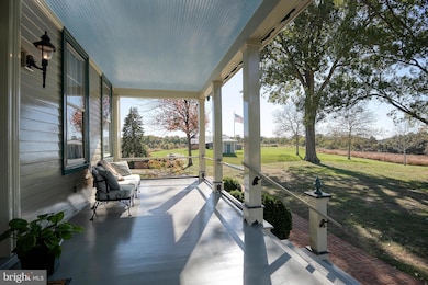
Gobbler Hill, circa 1858 with an addition built in 1989, sits like a jewel atop one of the highest points in Kent County. Listed on the National Historic Registry, the transitional architecture is an excellent example of late Greek Revival to early Italianate. The property consists of four parcels totaling over 65 acres. Wildlife abounds on the fields of native prairie grasses, wild flowers, woods, approximately 20 tilled acres and a large pond. Impeccable attention was payed to maintaining the historic character of both the interior and exterior. From the Lincrusta wall covering, 19th century faux wood finishing, plaster medallions, white and sugar pine wood floors and crown molding on the 11 ft. ceilings to the monumental copper roof, the thoughtful restoration is stunning. The newer addition beautifully blends into the original section adding modern conveniences and natural light. The library boasts black walnut bookshelves constructed by a local craftsman. Well maintained grounds offer gardens, mature trees, a classic poured concrete in ground pool with inlaid tile and stunning views. This unique, lovingly restored piece of Kent County history is now looking for a new steward to guide it into its next chapter.
Last Agent to Sell the Property
(410) 778-0330 tstone@cbchesapeake.com Coldwell Banker Chesapeake Real Estate Company Brokerage Phone: 4107780330 Listed on: 10/30/2025
Last Buyer's Agent
Unrepresented
datacorrect@brightmls.com Unrepresented Buyer Office
| Date | Type | Sale Price | Title Company |
|---|---|---|---|
| Deed | $2,100,000 | None Listed On Document | |
| Deed | -- | None Listed On Document | |
| Deed | -- | None Listed On Document | |
| Deed | -- | -- | |
| Deed | -- | -- | |
| Deed | $190,000 | -- |
| Date | Status | Loan Amount | Loan Type |
|---|---|---|---|
| Open | $1,680,000 | New Conventional |
| Date | Event | Price | List to Sale | Price per Sq Ft |
|---|---|---|---|---|
| 02/02/2026 02/02/26 | Sold | $2,100,000 | -10.6% | $424 / Sq Ft |
| 12/27/2025 12/27/25 | Pending | -- | -- | -- |
| 10/30/2025 10/30/25 | For Sale | $2,350,000 | -- | $474 / Sq Ft |
| Year | Tax Paid | Tax Assessment Tax Assessment Total Assessment is a certain percentage of the fair market value that is determined by local assessors to be the total taxable value of land and additions on the property. | Land | Improvement |
|---|---|---|---|---|
| 2025 | $5,060 | $455,300 | $0 | $0 |
| 2024 | $4,807 | $418,600 | $73,300 | $345,300 |
| 2023 | $4,632 | $412,667 | $0 | $0 |
| 2022 | $4,632 | $406,733 | $0 | $0 |
| 2021 | $4,560 | $400,800 | $73,300 | $327,500 |
| 2020 | $4,560 | $396,833 | $0 | $0 |
| 2019 | $4,515 | $392,867 | $0 | $0 |
| 2018 | $4,470 | $388,900 | $73,300 | $315,600 |
| 2017 | $4,449 | $388,900 | $0 | $0 |
| 2016 | -- | $388,900 | $0 | $0 |
| 2015 | $3,292 | $393,700 | $0 | $0 |
| 2014 | $3,292 | $389,667 | $0 | $0 |
Seller's Agent in 2026
Tracy Stone
Coldwell Banker Chesapeake Real Estate Company
(443) 480-0610
40 Total Sales
U
Buyer's Agent in 2026
Unrepresented
Unrepresented Buyer Office
Source: Bright MLS
MLS Number: MDKE2005852
APN: 06-004938
Disclaimer: Certain information contained herein is derived from information provided by parties other than Homes.com. All information provided is deemed reliable, but is not guaranteed to be accurate and should be independently verified.
![]() The data relating to real estate for sale on this website appears in part through the BRIGHT Internet Data Exchange program, a voluntary cooperative exchange of property listing data between licensed real estate brokerage firms, and is provided by BRIGHT through a licensing agreement.
The data relating to real estate for sale on this website appears in part through the BRIGHT Internet Data Exchange program, a voluntary cooperative exchange of property listing data between licensed real estate brokerage firms, and is provided by BRIGHT through a licensing agreement.
Listing information is from various brokers who participate in the Bright MLS IDX program and not all listings may be visible on the site.
The property information being provided on or through the website is for the personal, non-commercial use of consumers and such information may not be used for any purpose other than to identify prospective properties consumers may be interested in purchasing.
Some properties which appear for sale on the website may no longer be available because they are for instance, under contract, sold or are no longer being offered for sale.
Property information displayed is deemed reliable but is not guaranteed.
Copyright 2026 Bright MLS, Inc.
Ask me questions while you tour the home.