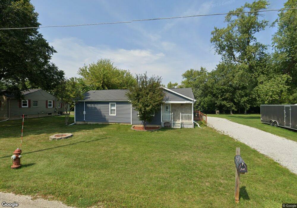
10124 Bain Station Rd Pleasant Prairie, WI 53158
Village of Pleasant Prairie NeighborhoodEstimated Value: $305,389 - $330,000
2
Beds
2
Baths
1,371
Sq Ft
$232/Sq Ft
Est. Value
About This Home
This home is located at 10124 Bain Station Rd, Pleasant Prairie, WI 53158 and is currently estimated at $318,347, approximately $232 per square foot. 10124 Bain Station Rd is a home located in Kenosha County with nearby schools including Pleasant Prairie Elementary School, Mahone Middle School, and Indian Trail High School And Academy.
Ownership History
Date
Name
Owned For
Owner Type
Purchase Details
Closed on
Feb 2, 2022
Sold by
Grinus and Milanka
Bought by
James R Nutini Revocable Trust
Current Estimated Value
Purchase Details
Closed on
Jan 20, 2011
Sold by
Deutsche Bank National Trust Company As
Bought by
Grinus Allen
Purchase Details
Closed on
Jul 14, 2009
Sold by
Willis William R
Bought by
Deutsche Bank National Trust Company As
Create a Home Valuation Report for This Property
The Home Valuation Report is an in-depth analysis detailing your home's value as well as a comparison with similar homes in the area
Home Values in the Area
Average Home Value in this Area
Purchase History
| Date | Buyer | Sale Price | Title Company |
|---|---|---|---|
| James R Nutini Revocable Trust | $220,850 | Knight Barry Title, Inc. | |
| Grinus Allen | $55,000 | -- | |
| Deutsche Bank National Trust Company As | $66,000 | -- |
Source: Public Records
Tax History Compared to Growth
Tax History
| Year | Tax Paid | Tax Assessment Tax Assessment Total Assessment is a certain percentage of the fair market value that is determined by local assessors to be the total taxable value of land and additions on the property. | Land | Improvement |
|---|---|---|---|---|
| 2024 | $3,042 | $273,500 | $52,500 | $221,000 |
| 2023 | $3,007 | $237,600 | $47,700 | $189,900 |
| 2022 | $2,616 | $204,900 | $47,700 | $157,200 |
| 2021 | $2,646 | $151,700 | $39,600 | $112,100 |
| 2020 | $2,726 | $151,700 | $39,600 | $112,100 |
| 2019 | $2,485 | $151,700 | $39,600 | $112,100 |
| 2018 | $2,541 | $151,700 | $39,600 | $112,100 |
| 2017 | $2,905 | $134,600 | $35,800 | $98,800 |
| 2016 | $2,868 | $134,600 | $35,800 | $98,800 |
| 2015 | $2,648 | $136,300 | $34,400 | $101,900 |
| 2014 | -- | $136,300 | $34,400 | $101,900 |
Source: Public Records
Map
Nearby Homes
- 9607 82nd Place
- 8156 Ridgeway Ct
- Lt1 Prairie Ridge Blvd
- 8567 83rd St
- Lt0 75th St
- The Cedar 1 Plan at Bain Station - The Summit
- The Cedar 2 Plan at Bain Station - The Summit
- The Juniper 2 Plan at Bain Station - The Summit
- The Juniper 1 Plan at Bain Station - The Summit
- The Aspen Plan at Bain Station - The Summit
- 10020 74th St Unit C
- 10020 74th St Unit E
- 7222 96th Ave
- 7801 88th Ave Unit 1
- 7801 88th Ave Unit 72
- 7801 88th Ave Unit 85
- 7801 88th Ave Unit 84
- 7801 88th Ave Unit 62
- 7801 88th Ave Unit 103
- 7801 88th Ave Unit 73
- 10200 Bain Station Rd
- 10114 Bain Station Rd
- 10220 Bain Station Rd
- 10127 Bain Station Rd
- 10255 Bain Station Rd
- 8499 E Ridge Dr
- 8435 103rd Ave
- 8439 103rd Ave
- 10206 Wilmot Rd
- 8497 E Ridge Dr
- 8494 E Ridge Dr
- 8425 103rd Ave
- 8509 103rd Ave
- 10010 Wilmot Rd
- 8519 103rd Ave
- 8491 E Ridge Dr
- 10009 Wilmot Rd
- 8436 103rd Ave
- 10222 Wilmot Rd
- 8454 103rd Ave