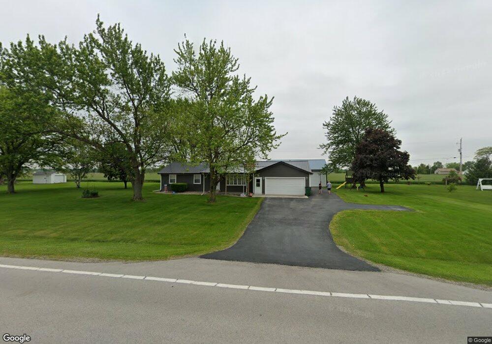
10124 State Route 111 Paulding, OH 45879
Estimated Value: $172,737 - $204,000
3
Beds
3
Baths
1,462
Sq Ft
$129/Sq Ft
Est. Value
About This Home
This home is located at 10124 State Route 111, Paulding, OH 45879 and is currently estimated at $188,684, approximately $129 per square foot. 10124 State Route 111 is a home located in Paulding County with nearby schools including Paulding High School.
Ownership History
Date
Name
Owned For
Owner Type
Purchase Details
Closed on
May 26, 2018
Sold by
Phillips Robert Leo and Phillips Danielle L
Bought by
Phillips Robert Leo and Phillips Danielle L
Current Estimated Value
Purchase Details
Closed on
Jul 5, 2007
Sold by
Snipes Edward B and Snipes Brandy D
Bought by
Phillips Robert Leo
Home Financials for this Owner
Home Financials are based on the most recent Mortgage that was taken out on this home.
Original Mortgage
$92,500
Outstanding Balance
$56,565
Interest Rate
6.54%
Mortgage Type
VA
Estimated Equity
$132,119
Purchase Details
Closed on
Oct 10, 1984
Bought by
Phillips Robert Leo
Create a Home Valuation Report for This Property
The Home Valuation Report is an in-depth analysis detailing your home's value as well as a comparison with similar homes in the area
Purchase History
| Date | Buyer | Sale Price | Title Company |
|---|---|---|---|
| Phillips Robert Leo | -- | None Available | |
| Phillips Robert Leo | $92,500 | None Available | |
| Phillips Robert Leo | -- | -- |
Source: Public Records
Mortgage History
| Date | Status | Borrower | Loan Amount |
|---|---|---|---|
| Open | Phillips Robert Leo | $92,500 |
Source: Public Records
Tax History
| Year | Tax Paid | Tax Assessment Tax Assessment Total Assessment is a certain percentage of the fair market value that is determined by local assessors to be the total taxable value of land and additions on the property. | Land | Improvement |
|---|---|---|---|---|
| 2025 | $1,724 | $52,680 | $5,920 | $46,760 |
| 2024 | $1,724 | $39,590 | $4,550 | $35,040 |
| 2023 | $1,403 | $39,590 | $4,550 | $35,040 |
| 2022 | $1,349 | $39,590 | $4,550 | $35,040 |
| 2021 | $1,192 | $32,900 | $4,550 | $28,350 |
| 2020 | $1,232 | $32,900 | $4,550 | $28,350 |
| 2019 | $1,244 | $30,310 | $4,550 | $25,760 |
| 2018 | $1,155 | $30,310 | $4,550 | $25,760 |
| 2017 | $1,156 | $28,700 | $4,550 | $24,150 |
| 2016 | $1,094 | $28,700 | $4,550 | $24,150 |
| 2015 | $921 | $24,610 | $4,550 | $20,060 |
| 2014 | $915 | $24,610 | $4,550 | $20,060 |
| 2013 | $1,010 | $24,610 | $4,550 | $20,060 |
Source: Public Records
Map
Nearby Homes
- 11051 Road 93
- 714 W Wayne St
- 717 W Harrison St
- 614 W Jackson St
- 215 N Dewitt St
- 520 W Wayne St
- 508 W Jackson St
- 829 Greenbriar Ave
- 402 N Williams St
- 830 N Walnut St
- 516 N Williams St
- 308 N Main St
- 780 N Williams St
- 301 N Main St
- 726 N Main St
- 701 E Wayne St
- 742 E Perry St
- 741 Tom Tim Dr
- 1065 Emerald Rd
- 13688 Kay St
- 10124 Ohio 111
- 10086 State Route 111
- 10160 State Route 111
- 10048 State Route 111
- 10041 State Route 111
- 10198 State Route 111
- 10030 State Route 111
- 10944 Road 87
- 10972 Road 87
- 10236 State Route 111
- 10906 Road 87
- 10951 Road 87
- 10931 Road 87
- 10913 Road 87
- 10872 Road 87
- 10895 Road 87
- 9970 State Route 111
- 10844 Road 87
- 10824 Road 87
- 10857 Road 87
Your Personal Tour Guide
Ask me questions while you tour the home.