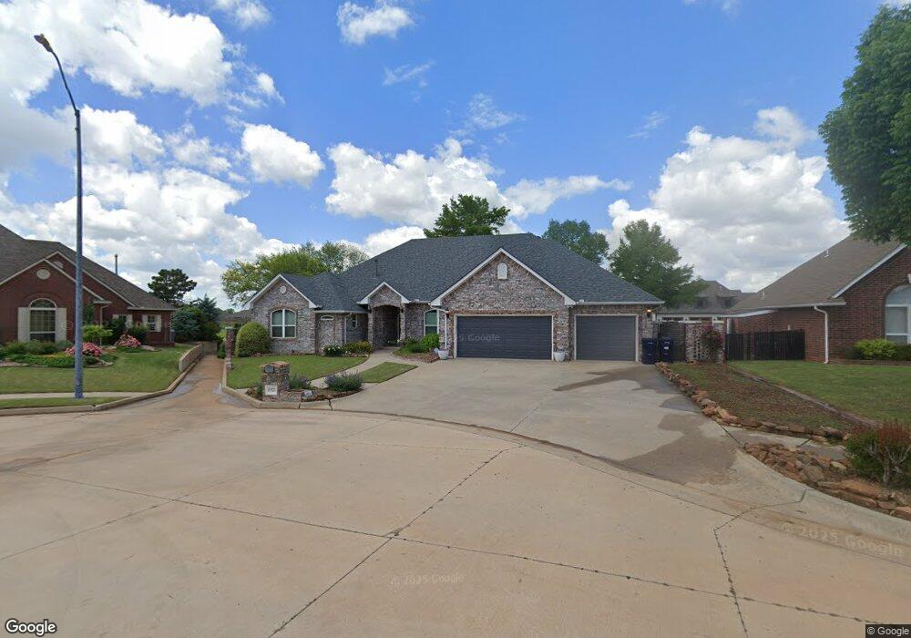
10125 Millspaugh Way Yukon, OK 73099
Westbury South NeighborhoodEstimated Value: $391,357 - $478,000
3
Beds
4
Baths
3,000
Sq Ft
$139/Sq Ft
Est. Value
About This Home
This home is located at 10125 Millspaugh Way, Yukon, OK 73099 and is currently estimated at $416,589, approximately $138 per square foot. 10125 Millspaugh Way is a home located in Canadian County with nearby schools including Mustang Valley Elementary School, Canyon Ridge Intermediate School, and Mustang North Middle School.
Ownership History
Date
Name
Owned For
Owner Type
Purchase Details
Closed on
Jul 8, 2008
Sold by
Barr Denise Ann
Bought by
Barr Denise Ann and Denise Ann Barr 2002 Revocable
Current Estimated Value
Purchase Details
Closed on
Dec 28, 2007
Sold by
Barr C Keith and Barr Denise Ann
Bought by
Barr C Keith and Barr Denise Ann
Purchase Details
Closed on
Jan 26, 1999
Sold by
Barr C Keith
Purchase Details
Closed on
Jul 23, 1997
Sold by
Adams Honay L
Purchase Details
Closed on
Apr 14, 1995
Sold by
D H M Enterprises
Create a Home Valuation Report for This Property
The Home Valuation Report is an in-depth analysis detailing your home's value as well as a comparison with similar homes in the area
Home Values in the Area
Average Home Value in this Area
Purchase History
| Date | Buyer | Sale Price | Title Company |
|---|---|---|---|
| Barr Denise Ann | -- | None Available | |
| Barr C Keith | -- | None Available | |
| Barr C Keith | -- | None Available | |
| -- | -- | -- | |
| -- | -- | -- | |
| -- | $40,000 | -- |
Source: Public Records
Tax History Compared to Growth
Tax History
| Year | Tax Paid | Tax Assessment Tax Assessment Total Assessment is a certain percentage of the fair market value that is determined by local assessors to be the total taxable value of land and additions on the property. | Land | Improvement |
|---|---|---|---|---|
| 2024 | $4,103 | $38,048 | $3,696 | $34,352 |
| 2023 | $4,103 | $36,236 | $3,696 | $32,540 |
| 2022 | $3,967 | $34,510 | $3,696 | $30,814 |
| 2021 | $4,038 | $35,261 | $3,696 | $31,565 |
| 2020 | $4,122 | $35,636 | $3,696 | $31,940 |
| 2019 | $4,141 | $35,835 | $3,696 | $32,139 |
| 2018 | $4,017 | $34,129 | $3,696 | $30,433 |
| 2017 | $4,064 | $34,978 | $4,200 | $30,778 |
| 2016 | $3,938 | $34,141 | $4,200 | $29,941 |
| 2015 | $3,879 | $32,370 | $4,200 | $28,170 |
| 2014 | $3,879 | $33,220 | $4,200 | $29,020 |
Source: Public Records
Map
Nearby Homes
- 10101 SW 27th St
- 10049 SW 27th St
- 2716 Busheywood Dr
- 2828 Ryder Dr
- 2808 Ryder Dr
- 10109 SW 25th Ct
- 2509 Crystal Creek Dr
- 2901 Morgan Trace
- 10217 SW 24th St
- 10040 SW 22nd St
- 2405 Crystal Creek Dr
- 2705 Tracys Manor
- 2525 Tracy’s Manor
- 2705 Tracy’s Manor
- 10025 SW 21st St
- 2616 Kathleens Crossing
- 3213 Open Prairie Trail
- 3317 Open Prairie Trail
- 2617 Kathleens Crossing
- 2612 Kathleens Crossing
- 10117 Millspaugh Way
- 2901 Millspaugh Way
- 10109 Millspaugh Way
- 2909 Millspaugh Way
- 10108 Millspaugh Way
- 10101 Millspaugh Way
- 10116 Daughety Dr
- 2917 Millspaugh Way
- 10100 Millspaugh Way
- 2816 Crystal Creek Dr
- 10108 Daughety Dr
- 2808 Deer Valley Ln
- 2804 Crystal Creek Dr
- 10049 Millspaugh Way
- 2808 Crystal Creek Dr
- 2800 Crystal Creek Dr
- 10048 Millspaugh Way
- 2829 Crystal Creek Dr
- 10100 Daughety Dr
- 2804 Deer Valley Ln