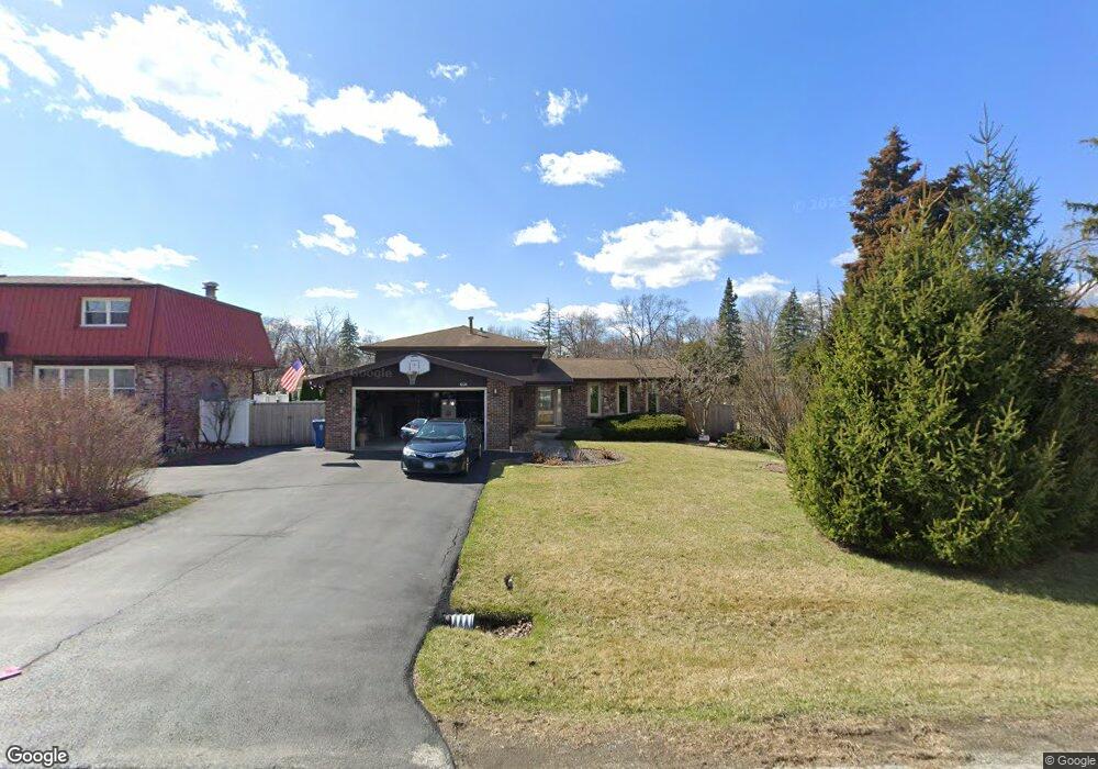
10126 S 81st Ave Palos Hills, IL 60465
Estimated Value: $334,000 - $455,000
3
Beds
2
Baths
1,682
Sq Ft
$246/Sq Ft
Est. Value
About This Home
This home is located at 10126 S 81st Ave, Palos Hills, IL 60465 and is currently estimated at $413,373, approximately $245 per square foot. 10126 S 81st Ave is a home located in Cook County with nearby schools including Sorrick Elementary School, Oak Ridge Elementary School, and H H Conrady Jr High School.
Ownership History
Date
Name
Owned For
Owner Type
Purchase Details
Closed on
Aug 31, 2004
Sold by
Jacsinick Michael N
Bought by
Sendra Janice
Current Estimated Value
Purchase Details
Closed on
May 22, 2001
Sold by
Marquette National Bank
Bought by
Jaksinick Michael N
Home Financials for this Owner
Home Financials are based on the most recent Mortgage that was taken out on this home.
Original Mortgage
$115,000
Interest Rate
7.22%
Create a Home Valuation Report for This Property
The Home Valuation Report is an in-depth analysis detailing your home's value as well as a comparison with similar homes in the area
Home Values in the Area
Average Home Value in this Area
Purchase History
| Date | Buyer | Sale Price | Title Company |
|---|---|---|---|
| Sendra Janice | $125,000 | -- | |
| Jaksinick Michael N | -- | -- |
Source: Public Records
Mortgage History
| Date | Status | Borrower | Loan Amount |
|---|---|---|---|
| Previous Owner | Jaksinick Michael N | $115,000 |
Source: Public Records
Tax History Compared to Growth
Tax History
| Year | Tax Paid | Tax Assessment Tax Assessment Total Assessment is a certain percentage of the fair market value that is determined by local assessors to be the total taxable value of land and additions on the property. | Land | Improvement |
|---|---|---|---|---|
| 2024 | $7,811 | $33,000 | $7,731 | $25,269 |
| 2023 | $5,735 | $33,000 | $7,731 | $25,269 |
| 2022 | $5,735 | $21,874 | $6,733 | $15,141 |
| 2021 | $5,615 | $21,873 | $6,733 | $15,140 |
| 2020 | $5,639 | $21,873 | $6,733 | $15,140 |
| 2019 | $6,980 | $26,418 | $6,234 | $20,184 |
| 2018 | $6,715 | $26,418 | $6,234 | $20,184 |
| 2017 | $6,511 | $26,418 | $6,234 | $20,184 |
| 2016 | $7,696 | $24,774 | $5,486 | $19,288 |
| 2015 | $7,545 | $24,774 | $5,486 | $19,288 |
| 2014 | $7,428 | $24,774 | $5,486 | $19,288 |
| 2013 | $6,989 | $24,928 | $5,486 | $19,442 |
Source: Public Records
Map
Nearby Homes
- 10125 S 81st Ct
- 10226 S 81st Ave
- 10324 S 81st Ave
- 10221 S Eleanor Ave
- 9940 S Wood Ln
- 8360 W 100th Place
- 10230 S 83rd Ct
- 7810 W 102nd St
- 7822 W 99th Place
- 9950 S 84th Terrace Unit 215
- 9954 S 84th Terrace Unit 109
- 9719 S 81st Ave
- 7826 W 98th Place
- 10409 Sheffield Dr Unit 13
- 10441 S 83rd Ave
- 10300 S Kathy Ct
- 10427 S Alta Dr
- 10408 S Alta Dr
- 10531 S Roberts Rd Unit 2D
- 10025 S 86th Ct
- 10128 S 81st Ave
- 10100 S 81st Ave
- 10111 S 81st Ct
- 10113 S 81st Ct
- 10136 S 81st Ave
- 10090 S 81st Ave
- 10115 S 81st Ave
- 10101 S 81st Ct
- 10115 S 81st Ct
- 10111 S 81st Ave
- 10117 S 81st Ave
- 10144 S 81st Ave
- 10101 S 81st Ave
- 10119 S 81st Ave
- 10117 S 81st Ct
- 10121 S 81st Ave
- 10086 S 81st Ave
- 10108 S 81st Ct
- 10122 S 80th Ct
- 8115 W Erin Dr