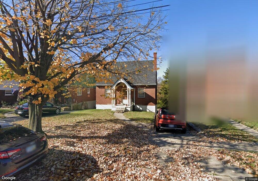
1013 Fisk Ave Cincinnati, OH 45205
West Price Hill NeighborhoodEstimated Value: $126,000 - $212,000
2
Beds
2
Baths
1,176
Sq Ft
$141/Sq Ft
Est. Value
About This Home
This home is located at 1013 Fisk Ave, Cincinnati, OH 45205 and is currently estimated at $165,890, approximately $141 per square foot. 1013 Fisk Ave is a home located in Hamilton County with nearby schools including Carson School, Gilbert A. Dater High School, and Western Hills High School.
Ownership History
Date
Name
Owned For
Owner Type
Purchase Details
Closed on
Jun 29, 1999
Sold by
Abrams Jeffrey L and Abrams Heather L
Bought by
Mueller Matthew E and Mueller Melissa M
Current Estimated Value
Home Financials for this Owner
Home Financials are based on the most recent Mortgage that was taken out on this home.
Original Mortgage
$89,720
Interest Rate
7.43%
Mortgage Type
Unknown
Create a Home Valuation Report for This Property
The Home Valuation Report is an in-depth analysis detailing your home's value as well as a comparison with similar homes in the area
Home Values in the Area
Average Home Value in this Area
Purchase History
| Date | Buyer | Sale Price | Title Company |
|---|---|---|---|
| Mueller Matthew E | $91,000 | -- |
Source: Public Records
Mortgage History
| Date | Status | Borrower | Loan Amount |
|---|---|---|---|
| Closed | Mueller Matthew E | $89,720 |
Source: Public Records
Tax History
| Year | Tax Paid | Tax Assessment Tax Assessment Total Assessment is a certain percentage of the fair market value that is determined by local assessors to be the total taxable value of land and additions on the property. | Land | Improvement |
|---|---|---|---|---|
| 2025 | $2,091 | $33,807 | $4,526 | $29,281 |
| 2023 | $2,073 | $33,807 | $4,526 | $29,281 |
| 2022 | $1,497 | $21,844 | $4,498 | $17,346 |
| 2021 | $1,438 | $21,844 | $4,498 | $17,346 |
| 2020 | $1,480 | $21,844 | $4,498 | $17,346 |
| 2019 | $1,471 | $19,856 | $4,088 | $15,768 |
| 2018 | $1,473 | $19,856 | $4,088 | $15,768 |
| 2017 | $1,399 | $19,856 | $4,088 | $15,768 |
| 2016 | $1,511 | $21,147 | $4,368 | $16,779 |
| 2015 | $1,362 | $21,147 | $4,368 | $16,779 |
| 2014 | $1,372 | $21,147 | $4,368 | $16,779 |
| 2013 | $1,584 | $24,031 | $4,963 | $19,068 |
Source: Public Records
Map
Nearby Homes
- 4120 Saint Williams Ave
- 1002 Winfield Ave
- 1026 Schiff Ave
- 1110 Winfield Ave
- 832 Sunset Ave
- 1226 Rutledge Ave
- 4614 Midland Ave
- 1113 Gilsey Ave
- 4526 Clearview Ave
- 831 Suire Ave
- 4247 Eighth St W
- 4318 Eighth St W
- 4261 Eighth St W
- 4334 W 8th St
- 1222 Dewey Ave
- 700 Trenton Ave
- 4340 Eighth St W
- 836 Harris Ave
- 2403 Glenway Ave
- 620 Trenton Ave
- 1011 Fisk Ave
- 1015 Fisk Ave
- 1009 Fisk Ave
- 1017 Fisk Ave
- 1019 Fisk Ave
- 4140 Saint Lawrence Ave
- 1012 Fisk Ave
- 1023 Fisk Ave
- 1014 Fisk Ave
- 1007 Fisk Ave
- 1010 Fisk Ave
- 1018 Fisk Ave
- 1008 Fisk Ave
- 1030 Rutledge Ave
- 1022 Fisk Ave
- 1005 Fisk Ave
- 1027 Fisk Ave
- 1032 Rutledge Ave
- 1024 Rutledge Ave
- 1022 Rutledge Ave
Your Personal Tour Guide
Ask me questions while you tour the home.