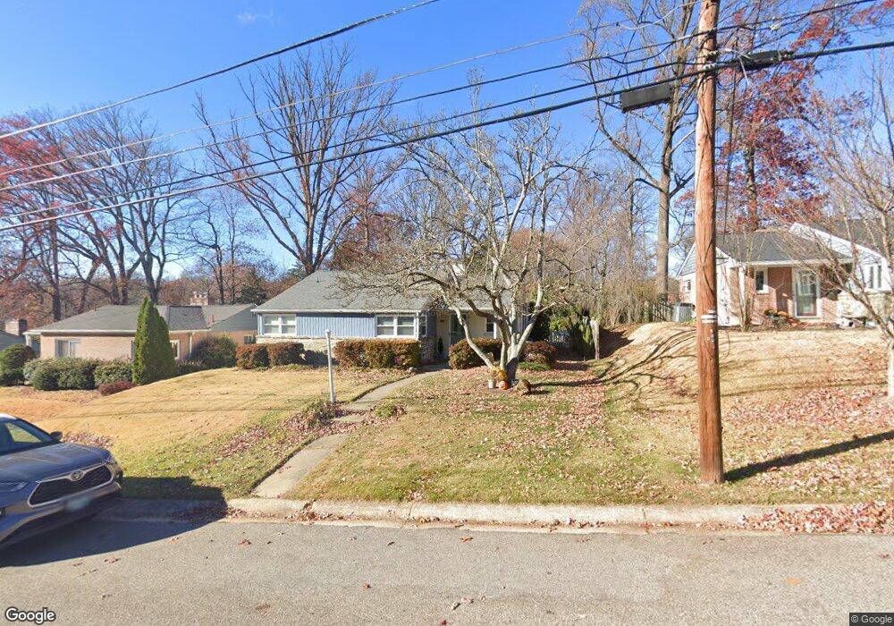
1013 Roswell Dr Silver Spring, MD 20901
South Four Corners NeighborhoodEstimated Value: $589,000 - $629,000
3
Beds
2
Baths
1,378
Sq Ft
$441/Sq Ft
Est. Value
About This Home
This home is located at 1013 Roswell Dr, Silver Spring, MD 20901 and is currently estimated at $607,713, approximately $441 per square foot. 1013 Roswell Dr is a home located in Montgomery County with nearby schools including Flora M. Singer Elementary School, Sligo Middle School, and Albert Einstein High School.
Ownership History
Date
Name
Owned For
Owner Type
Purchase Details
Closed on
Oct 3, 2011
Sold by
Brower Anne K and Brower Ward L
Bought by
Marsick Megan E
Current Estimated Value
Home Financials for this Owner
Home Financials are based on the most recent Mortgage that was taken out on this home.
Original Mortgage
$224,400
Outstanding Balance
$153,418
Interest Rate
4.15%
Mortgage Type
New Conventional
Estimated Equity
$454,295
Create a Home Valuation Report for This Property
The Home Valuation Report is an in-depth analysis detailing your home's value as well as a comparison with similar homes in the area
Home Values in the Area
Average Home Value in this Area
Purchase History
| Date | Buyer | Sale Price | Title Company |
|---|---|---|---|
| Marsick Megan E | $280,500 | Chicago Title Insurance Co |
Source: Public Records
Mortgage History
| Date | Status | Borrower | Loan Amount |
|---|---|---|---|
| Open | Marsick Megan E | $224,400 |
Source: Public Records
Tax History
| Year | Tax Paid | Tax Assessment Tax Assessment Total Assessment is a certain percentage of the fair market value that is determined by local assessors to be the total taxable value of land and additions on the property. | Land | Improvement |
|---|---|---|---|---|
| 2025 | $6,358 | $532,800 | $211,100 | $321,700 |
| 2024 | $6,358 | $488,767 | $0 | $0 |
| 2023 | $5,089 | $444,733 | $0 | $0 |
| 2022 | $3,230 | $400,700 | $211,100 | $189,600 |
| 2021 | $494 | $381,500 | $0 | $0 |
| 2020 | $3,859 | $362,300 | $0 | $0 |
| 2019 | $3,612 | $343,100 | $196,400 | $146,700 |
| 2018 | $3,586 | $343,000 | $0 | $0 |
| 2017 | $3,643 | $342,900 | $0 | $0 |
| 2016 | -- | $342,800 | $0 | $0 |
| 2015 | $2,944 | $327,900 | $0 | $0 |
| 2014 | $2,944 | $313,000 | $0 | $0 |
Source: Public Records
Map
Nearby Homes
- 10015 Reddick Dr
- 10006 Portland Place
- 10110 Dallas Ave
- 10128 Dallas Ave
- 10104 Kinross Ave
- 603 Perth Place
- 812 Forest Glen Rd
- 10405 Inwood Ave
- 9910 Lorain Ave
- 1616 Tilton Dr
- 513 Kerwin Ct
- 1518 Gridley Ln
- 9624 Brunett Ave
- 1806 Tilton Dr
- 9707 Saxony Rd
- 2002 Medical Park Dr
- 827 University Blvd W
- 10149 Sutherland Rd
- 1809 Florin St
- 1401 Jasper St
- 1015 Roswell Dr
- 1011 Roswell Dr
- 1114 Meurilee Ln
- 1017 Roswell Dr
- 1009 Roswell Dr
- 1112 Meurilee Ln
- 1116 Meurilee Ln
- 1118 Meurilee Ln
- 1006 Roswell Dr
- 1110 Meurilee Ln
- 1008 Roswell Dr
- 1019 Roswell Dr
- 1007 Roswell Dr
- 10110 Quinby St
- 1120 Meurilee Ln
- 1010 Roswell Dr
- 1108 Meurilee Ln
- 10108 Quinby St
- 1005 Roswell Dr
- 1122 Meurilee Ln
Your Personal Tour Guide
Ask me questions while you tour the home.