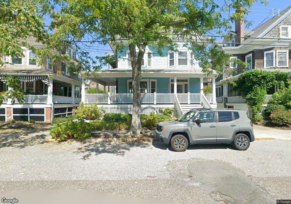
1013 Stockton Ave Cape May, NJ 08204
Estimated Value: $2,184,000 - $2,590,000
1
Bed
3
Baths
2,651
Sq Ft
$904/Sq Ft
Est. Value
About This Home
This home is located at 1013 Stockton Ave, Cape May, NJ 08204 and is currently estimated at $2,395,771, approximately $903 per square foot. 1013 Stockton Ave is a home located in Cape May County with nearby schools including Cape May City Elementary School, Richard M. Teitelman School, and Lower Cape May Regional High School.
Ownership History
Date
Name
Owned For
Owner Type
Purchase Details
Closed on
Jun 13, 2025
Sold by
Adams Amelia F
Bought by
Fisher Alan J and Fisher Amanda G
Current Estimated Value
Home Financials for this Owner
Home Financials are based on the most recent Mortgage that was taken out on this home.
Original Mortgage
$806,500
Outstanding Balance
$804,409
Interest Rate
6.76%
Mortgage Type
New Conventional
Estimated Equity
$1,591,362
Purchase Details
Closed on
Aug 2, 1991
Sold by
Kriebel Robert I and Kriebel Rebecca L
Bought by
Adams Wesley P and Adams Amelia F
Create a Home Valuation Report for This Property
The Home Valuation Report is an in-depth analysis detailing your home's value as well as a comparison with similar homes in the area
Home Values in the Area
Average Home Value in this Area
Purchase History
| Date | Buyer | Sale Price | Title Company |
|---|---|---|---|
| Fisher Alan J | $2,400,000 | Seaboard Title | |
| Fisher Alan J | $2,400,000 | Seaboard Title | |
| Adams Wesley P | $225,000 | -- | |
| Adams Wesley P | $225,000 | -- |
Source: Public Records
Mortgage History
| Date | Status | Borrower | Loan Amount |
|---|---|---|---|
| Open | Fisher Alan J | $806,500 | |
| Closed | Fisher Alan J | $806,500 |
Source: Public Records
Tax History Compared to Growth
Tax History
| Year | Tax Paid | Tax Assessment Tax Assessment Total Assessment is a certain percentage of the fair market value that is determined by local assessors to be the total taxable value of land and additions on the property. | Land | Improvement |
|---|---|---|---|---|
| 2025 | $11,108 | $1,050,900 | $793,800 | $257,100 |
| 2024 | $11,108 | $1,050,900 | $793,800 | $257,100 |
| 2023 | $11,287 | $1,050,900 | $793,800 | $257,100 |
| 2022 | $10,845 | $1,050,900 | $793,800 | $257,100 |
| 2021 | $10,161 | $1,050,900 | $793,800 | $257,100 |
| 2020 | $10,194 | $1,050,900 | $793,800 | $257,100 |
| 2019 | $10,372 | $1,050,900 | $793,800 | $257,100 |
| 2018 | $9,784 | $1,050,900 | $793,800 | $257,100 |
| 2017 | $9,290 | $1,050,900 | $793,800 | $257,100 |
| 2016 | $8,743 | $1,050,900 | $793,800 | $257,100 |
| 2015 | $9,090 | $1,050,900 | $793,800 | $257,100 |
| 2014 | $9,090 | $1,050,900 | $793,800 | $257,100 |
Source: Public Records
Map
Nearby Homes
- 918 Stockton Ave
- 610 Beach Ave
- 1025 New York Ave
- 819 Beach Ave Unit B1
- 106 Howard St Unit A
- 106 A Howard St
- 614 Jefferson St
- 519 Franklin St
- 626 Hughes St
- 645 Hughes St
- 1047 Virginia Ave
- 627 Hughes St
- 24 Ocean St
- 202 Ocean St
- 210 Ocean St Unit 1
- 933 Washington St
- 1132 Illinois Ave
- 1015 Washington St
- 1257 Cape May Ave
- 1110 Pennsylvania Ave
- 1009 Stockton Ave
- 1015 Stockton Ave
- 1017 Stockton Ave
- 1007 Stockton Ave
- 112 Madison Ave
- 112 Madison Ave Unit REAR COTTAGE
- 112 Madison Ave
- 1014 Kearney Ave
- 1018 Stockton Ave
- 116 Madison Ave
- 1012 Kearney Ave
- 1005 Stockton Ave
- 1020 Stockton Ave
- 1010 Kearney Ave
- 1016 Stockton Ave
- 1022 Stockton Ave
- 1003 Stockton Ave
- 101 Queen St
- 1012 Stockton Ave
- 105 Queen St