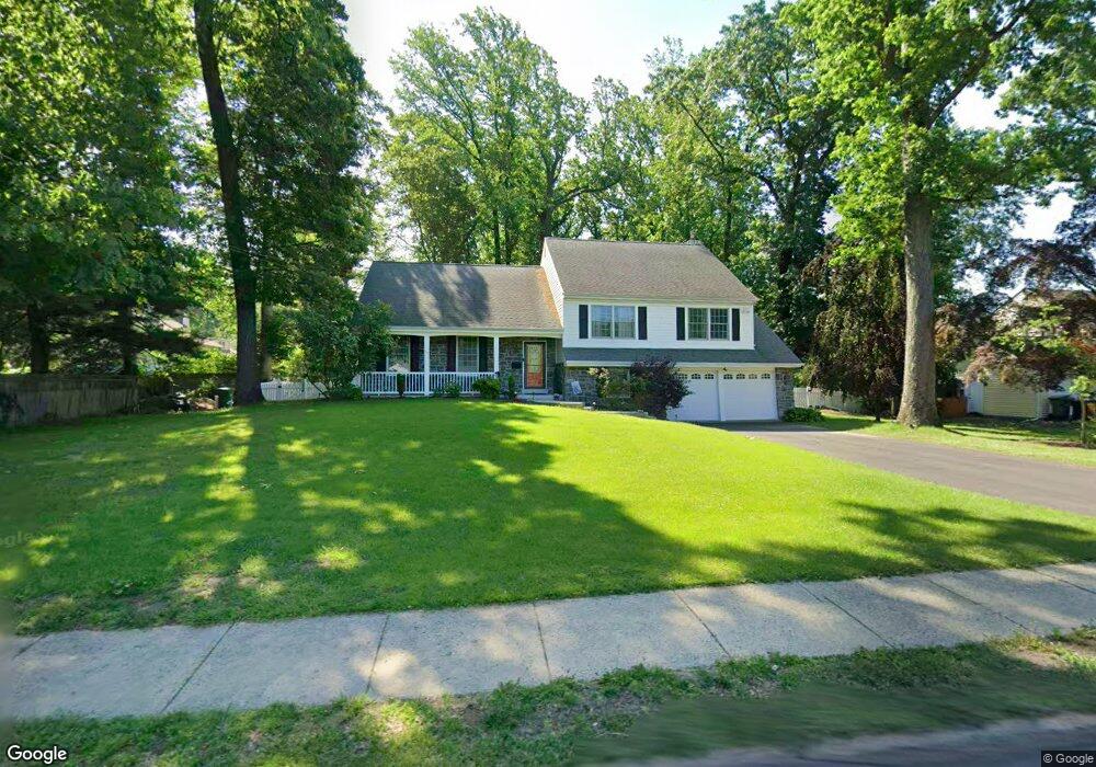
1013 Twining Rd Dresher, PA 19025
Estimated Value: $513,000 - $666,000
4
Beds
3
Baths
2,327
Sq Ft
$252/Sq Ft
Est. Value
About This Home
This home is located at 1013 Twining Rd, Dresher, PA 19025 and is currently estimated at $586,597, approximately $252 per square foot. 1013 Twining Rd is a home located in Montgomery County with nearby schools including Thomas Fitzwater Elementary School, Sandy Run Middle School, and Upper Dublin High School.
Ownership History
Date
Name
Owned For
Owner Type
Purchase Details
Closed on
Sep 30, 2004
Sold by
Not Provided
Bought by
Curotto Kathleen M and Curotto Emanuele
Current Estimated Value
Purchase Details
Closed on
Jun 21, 2004
Sold by
Not Provided
Bought by
Curotto Kathleen M and Curotto Emanuele
Purchase Details
Closed on
Mar 15, 2001
Sold by
Wood Jean A
Bought by
Wood Stephen
Purchase Details
Closed on
Feb 15, 1999
Sold by
Wood Jean A
Bought by
Wood Jean A
Purchase Details
Closed on
Mar 11, 1998
Sold by
Wood Melvin N and Wood Jean A
Bought by
Wood Jean A
Create a Home Valuation Report for This Property
The Home Valuation Report is an in-depth analysis detailing your home's value as well as a comparison with similar homes in the area
Home Values in the Area
Average Home Value in this Area
Purchase History
| Date | Buyer | Sale Price | Title Company |
|---|---|---|---|
| Curotto Kathleen M | -- | -- | |
| Curotto Kathleen M | -- | -- | |
| Wood Stephen | -- | -- | |
| Wood Jean A | -- | -- | |
| Wood Jean A | -- | -- | |
| Wood Jean A | -- | -- |
Source: Public Records
Mortgage History
| Date | Status | Borrower | Loan Amount |
|---|---|---|---|
| Closed | Curotto Kathleen M | $0 |
Source: Public Records
Tax History Compared to Growth
Tax History
| Year | Tax Paid | Tax Assessment Tax Assessment Total Assessment is a certain percentage of the fair market value that is determined by local assessors to be the total taxable value of land and additions on the property. | Land | Improvement |
|---|---|---|---|---|
| 2025 | $8,503 | $174,360 | -- | -- |
| 2024 | $8,503 | $174,360 | -- | -- |
| 2023 | $8,304 | $174,360 | $0 | $0 |
| 2022 | $8,123 | $174,360 | $0 | $0 |
| 2021 | $7,921 | $174,360 | $0 | $0 |
| 2020 | $7,692 | $174,360 | $0 | $0 |
| 2019 | $7,563 | $174,360 | $0 | $0 |
| 2018 | $7,563 | $174,360 | $0 | $0 |
| 2017 | $7,288 | $174,360 | $0 | $0 |
| 2016 | $7,219 | $174,360 | $0 | $0 |
| 2015 | $6,819 | $174,360 | $0 | $0 |
| 2014 | $6,819 | $168,790 | $54,030 | $114,760 |
Source: Public Records
Map
Nearby Homes
- 309 Woodside Cir
- 3225 Burn Brae Dr
- 1212 Duncan Dr
- 541 Cardinal Dr
- 536 Cardinal Dr
- 1120 Wilson Ave
- 3159 Burn Brae Dr
- 2933 Susquehanna Rd
- 3012 Lincoln Ave
- 501 Martin Ln
- 25 Northview Dr
- 743 Penn Ave
- 1371 Fitzwatertown Rd
- 2806 Anzac Ave
- 623 Penn Ave
- 2750 Turner Ave
- 1300 Kirks Ln
- 550 Penn Ave
- 722 Maple Ave
- 1380 Harris Rd
- 1009 Twining Rd
- 3278 Afton Rd
- 3274 Afton Rd
- 1005 Twining Rd
- 1008 Twining Rd
- 1030 Twining Rd
- 3270 Afton Rd
- 3273 Lenape Dr
- 1034 Twining Rd
- 1025 Twining Rd
- 1005 Windsor Ave
- 3277 Lenape Dr
- 1001 Twining Rd
- 1004 Twining Rd
- 3266 Afton Rd
- 3269 Lenape Dr
- 3275 Afton Rd
- 3310 Windsor Ave
- 0 Windsor Ave
- 932 Windsor Ave