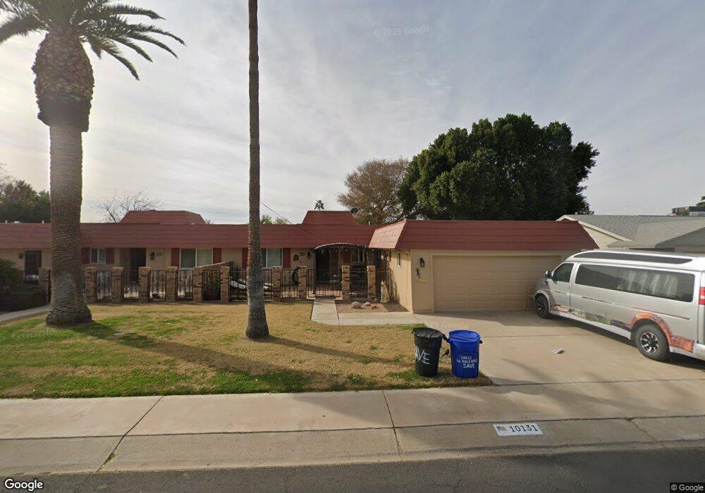
10131 W Bolivar Dr Unit 161 Sun City, AZ 85351
Estimated Value: $214,292 - $271,000
2
Beds
2
Baths
1,430
Sq Ft
$174/Sq Ft
Est. Value
About This Home
This home is located at 10131 W Bolivar Dr Unit 161, Sun City, AZ 85351 and is currently estimated at $248,573, approximately $173 per square foot. 10131 W Bolivar Dr Unit 161 is a home located in Maricopa County with nearby schools including Desert Mirage Elementary School, Ombudsman - Northwest Charter, and Arrowhead Montessori.
Ownership History
Date
Name
Owned For
Owner Type
Purchase Details
Closed on
Apr 23, 2009
Sold by
Kapitan David Glen and Kapitan Robert Luscombe
Bought by
Kimball James and Kimball Loretta
Current Estimated Value
Purchase Details
Closed on
Mar 20, 1996
Sold by
Kapitan Lucille
Bought by
Kapitan Lucille
Home Financials for this Owner
Home Financials are based on the most recent Mortgage that was taken out on this home.
Original Mortgage
$18,000
Interest Rate
6.98%
Create a Home Valuation Report for This Property
The Home Valuation Report is an in-depth analysis detailing your home's value as well as a comparison with similar homes in the area
Home Values in the Area
Average Home Value in this Area
Purchase History
| Date | Buyer | Sale Price | Title Company |
|---|---|---|---|
| Kimball James | $94,750 | First American Title Ins Co | |
| Kapitan Lucille | -- | Old Republic Title Agency |
Source: Public Records
Mortgage History
| Date | Status | Borrower | Loan Amount |
|---|---|---|---|
| Previous Owner | Kapitan Lucille | $18,000 |
Source: Public Records
Tax History Compared to Growth
Tax History
| Year | Tax Paid | Tax Assessment Tax Assessment Total Assessment is a certain percentage of the fair market value that is determined by local assessors to be the total taxable value of land and additions on the property. | Land | Improvement |
|---|---|---|---|---|
| 2025 | $962 | $10,861 | -- | -- |
| 2024 | $873 | $10,343 | -- | -- |
| 2023 | $873 | $18,880 | $3,770 | $15,110 |
| 2022 | $825 | $16,170 | $3,230 | $12,940 |
| 2021 | $843 | $14,530 | $2,900 | $11,630 |
| 2020 | $822 | $12,870 | $2,570 | $10,300 |
| 2019 | $811 | $12,220 | $2,440 | $9,780 |
| 2018 | $783 | $10,750 | $2,150 | $8,600 |
| 2017 | $757 | $9,400 | $1,880 | $7,520 |
| 2016 | $712 | $7,720 | $1,540 | $6,180 |
| 2015 | $678 | $7,020 | $1,400 | $5,620 |
Source: Public Records
Map
Nearby Homes
- 10134 W Forrester Dr
- 10137 W Forrester Dr Unit 20
- 10127 W Forrester Dr
- 10229 W Bolivar Dr
- 10114 W Candlewood Dr
- 10112 W Forrester Dr
- 13410 N Cedar Dr Unit 20
- 13620 N Hawthorn Dr
- 10114 W Royal Oak Rd Unit 20
- 13636 N Redwood Dr Unit 203
- 10012 W Bolivar Dr
- 13614 N Hawthorn Dr
- 13828 N Whispering Lake Dr
- 13832 N Crown Point
- 10309 W Floriade Dr Unit 18
- 13606 N Redwood Dr Unit 209
- 13836 N Kaanapali Dr
- 13605 N Redwood Dr
- 13626 N Tan Tara Point
- 13433 N Emberwood Dr
- 10127 W Bolivar Dr Unit 162
- 10135 W Bolivar Dr
- 10137 W Bolivar Dr
- 10132 W Forrester Dr
- 10125 W Bolivar Dr
- 10136 W Forrester Dr
- 10130 W Forrester Dr Unit 117
- 10121 W Bolivar Dr
- 10143 W Bolivar Dr
- 10132 W Bolivar Dr
- 10138 W Forrester Dr Unit 21
- 10136 W Bolivar Dr
- 10128 W Bolivar Dr
- 10128 W Forrester Dr
- 10140 W Bolivar Dr
- 10140 W Forrester Dr
- 10124 W Bolivar Dr Unit 392
- 10157 W Bolivar Dr
- 10126 W Forrester Dr Unit 20
- 10119 W Bolivar Dr