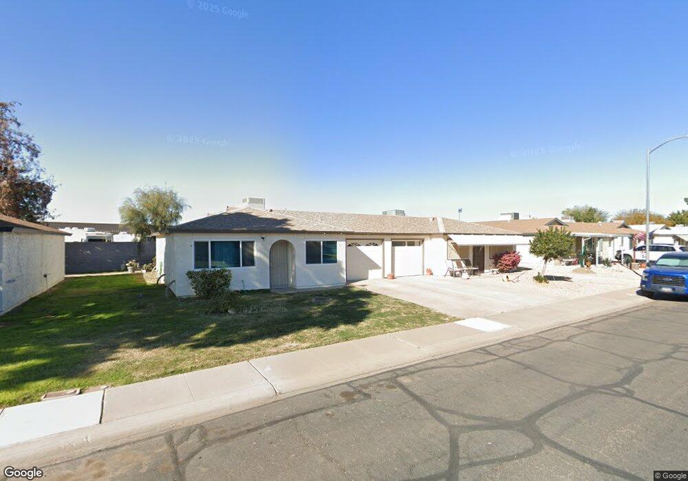
10132 N 97th Dr Unit B Peoria, AZ 85345
Estimated Value: $185,184 - $230,000
2
Beds
2
Baths
1,025
Sq Ft
$209/Sq Ft
Est. Value
About This Home
This home is located at 10132 N 97th Dr Unit B, Peoria, AZ 85345 and is currently estimated at $213,796, approximately $208 per square foot. 10132 N 97th Dr Unit B is a home located in Maricopa County with nearby schools including Sun Valley Elementary School, Raymond S. Kellis, and Ombudsman - Northwest Charter.
Ownership History
Date
Name
Owned For
Owner Type
Purchase Details
Closed on
Feb 10, 2006
Sold by
Brinkmeyer Paul H and Brinkmeyer Rosalie M
Bought by
Cooper Sheila A
Current Estimated Value
Home Financials for this Owner
Home Financials are based on the most recent Mortgage that was taken out on this home.
Original Mortgage
$87,500
Outstanding Balance
$49,230
Interest Rate
6.19%
Mortgage Type
New Conventional
Estimated Equity
$164,566
Purchase Details
Closed on
Feb 7, 2004
Sold by
Brinkmeyer Paul H and Brinkmeyer Rosalie M
Bought by
Brinkmeyer Paul H and Brinkmeyer Rosalie M
Purchase Details
Closed on
Dec 12, 1997
Sold by
Livin Dietz Robert A and Livin Robert S Dietz Revocable
Bought by
Brinkmeyer Paul H and Brinkmeyer Rosalie M
Home Financials for this Owner
Home Financials are based on the most recent Mortgage that was taken out on this home.
Original Mortgage
$36,750
Interest Rate
7.23%
Mortgage Type
New Conventional
Create a Home Valuation Report for This Property
The Home Valuation Report is an in-depth analysis detailing your home's value as well as a comparison with similar homes in the area
Home Values in the Area
Average Home Value in this Area
Purchase History
| Date | Buyer | Sale Price | Title Company |
|---|---|---|---|
| Cooper Sheila A | $125,000 | First American Title Ins Co | |
| Brinkmeyer Paul H | -- | -- | |
| Brinkmeyer Paul H | $52,500 | Nations Title Insurance |
Source: Public Records
Mortgage History
| Date | Status | Borrower | Loan Amount |
|---|---|---|---|
| Open | Cooper Sheila A | $87,500 | |
| Previous Owner | Brinkmeyer Paul H | $36,750 |
Source: Public Records
Tax History Compared to Growth
Tax History
| Year | Tax Paid | Tax Assessment Tax Assessment Total Assessment is a certain percentage of the fair market value that is determined by local assessors to be the total taxable value of land and additions on the property. | Land | Improvement |
|---|---|---|---|---|
| 2025 | $439 | $5,644 | -- | -- |
| 2024 | $433 | $5,375 | -- | -- |
| 2023 | $433 | $16,030 | $3,200 | $12,830 |
| 2022 | $424 | $12,280 | $2,450 | $9,830 |
| 2021 | $454 | $10,670 | $2,130 | $8,540 |
| 2020 | $458 | $9,870 | $1,970 | $7,900 |
| 2019 | $443 | $8,730 | $1,740 | $6,990 |
| 2018 | $428 | $6,930 | $1,380 | $5,550 |
| 2017 | $429 | $5,730 | $1,140 | $4,590 |
| 2016 | $424 | $5,150 | $1,030 | $4,120 |
| 2015 | $396 | $5,160 | $1,030 | $4,130 |
Source: Public Records
Map
Nearby Homes
- 10134 N 97th Ave Unit B
- 9616 W Mountain View Rd Unit A
- 10127 N 95th Dr Unit A
- 10201 N 99th Ave Unit 32A
- 10201 N 99th Ave Unit 46
- 10201 N 99th Ave Unit 44
- 10201 N 99th Ave Unit 97
- 10201 N 99th Ave Unit 34
- 10201 N 99th Ave Unit 28A
- 10201 N 99th Ave Unit 49
- 10201 N 99th Ave Unit 129E
- 10201 N 99th Ave Unit 135F
- 10201 N 99th Ave Unit 3
- 10201 N 99th Ave Unit 160
- 10201 N 99th Ave Unit 149
- 10201 N 99th Ave Unit 2
- 10201 N 99th Ave Unit 33
- 10201 N 99th Ave Unit 152
- 10201 N 99th Ave Unit 21
- 10201 N 99th Ave Unit 96
- 10132 N 97th Dr Unit A
- 10138 N 97th Dr
- 10138 N 97th Dr Unit B
- 10138 N 97th Dr Unit A
- 10126 N 97th Dr Unit B
- 10126 N 97th Dr Unit A
- 10126 N 97th Dr
- 10133 N 97th Dr Unit B
- 10117 N 97th Dr Unit B
- 10117 N 97th Dr Unit A
- 10202 N 97th Dr Unit B
- 10202 N 97th Dr Unit A
- 10141 N 97th Dr Unit B
- 10141 N 97th Dr Unit A
- 10118 N 97th Dr Unit B
- 10118 N 97th Dr Unit A
- 10109 N 97th Dr Unit B
- 10109 N 97th Dr Unit A
- 10206 N 97th Dr Unit B
- 10206 N 97th Dr Unit A