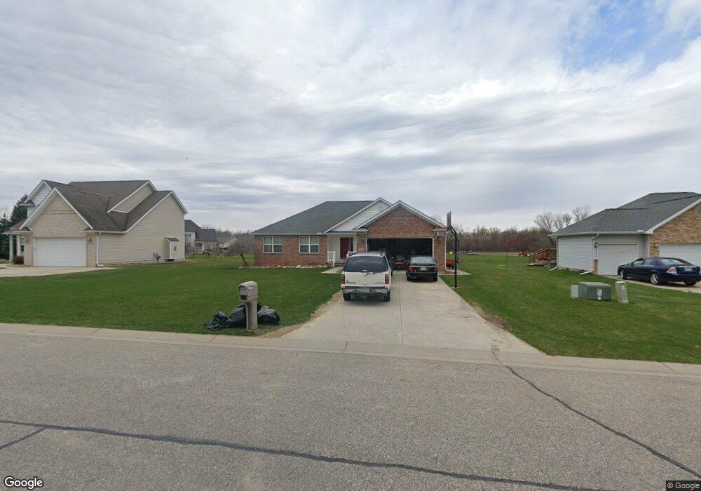
10135 Hunt Dr Davison, MI 48423
Estimated Value: $295,171 - $336,000
--
Bed
--
Bath
1,536
Sq Ft
$209/Sq Ft
Est. Value
About This Home
This home is located at 10135 Hunt Dr, Davison, MI 48423 and is currently estimated at $320,543, approximately $208 per square foot. 10135 Hunt Dr is a home located in Genesee County with nearby schools including Thomson Elementary School, Hill Elementary School, and Siple Elementary School.
Ownership History
Date
Name
Owned For
Owner Type
Purchase Details
Closed on
Apr 29, 2004
Sold by
Paternoster Kathleen
Bought by
Turner David C and Turner Christy M
Current Estimated Value
Purchase Details
Closed on
Jan 21, 2003
Sold by
Zampino Mark and Zampino Elaine G
Bought by
Paternoster Kathleen
Home Financials for this Owner
Home Financials are based on the most recent Mortgage that was taken out on this home.
Original Mortgage
$120,000
Interest Rate
7.75%
Mortgage Type
Purchase Money Mortgage
Purchase Details
Closed on
Jul 31, 2002
Sold by
Hunt Farm Estates Llc
Bought by
Zampino Mark
Create a Home Valuation Report for This Property
The Home Valuation Report is an in-depth analysis detailing your home's value as well as a comparison with similar homes in the area
Home Values in the Area
Average Home Value in this Area
Purchase History
| Date | Buyer | Sale Price | Title Company |
|---|---|---|---|
| Turner David C | $182,000 | Metropolitan Title Company | |
| Paternoster Kathleen | $177,500 | Lawyers Title | |
| Zampino Mark | $34,900 | Lawyers Title Insurance Corp |
Source: Public Records
Mortgage History
| Date | Status | Borrower | Loan Amount |
|---|---|---|---|
| Previous Owner | Paternoster Kathleen | $120,000 |
Source: Public Records
Tax History Compared to Growth
Tax History
| Year | Tax Paid | Tax Assessment Tax Assessment Total Assessment is a certain percentage of the fair market value that is determined by local assessors to be the total taxable value of land and additions on the property. | Land | Improvement |
|---|---|---|---|---|
| 2025 | $3,374 | $131,100 | $0 | $0 |
| 2024 | $978 | $127,900 | $0 | $0 |
| 2023 | $933 | $121,600 | $0 | $0 |
| 2022 | $2,999 | $104,200 | $0 | $0 |
| 2021 | $2,973 | $91,000 | $0 | $0 |
| 2020 | $854 | $89,200 | $0 | $0 |
| 2019 | $840 | $88,500 | $0 | $0 |
| 2018 | $1,705 | $83,500 | $0 | $0 |
| 2017 | $2,441 | $83,500 | $0 | $0 |
| 2016 | $2,396 | $79,500 | $0 | $0 |
| 2015 | $2,008 | $68,400 | $0 | $0 |
| 2014 | $800 | $70,700 | $0 | $0 |
| 2012 | -- | $68,400 | $68,400 | $0 |
Source: Public Records
Map
Nearby Homes
- 10190 Hunt Dr
- 9413 Blue Spruce Ct Unit 54
- 9805 E Richfield Rd
- 3369 Meadow Ridge Ct
- 3367 Meadow Ridge Ct
- 9440 E Potter Rd
- 3372 Spruceridge Ct Unit 82
- 3365 Spruceridge Ct Unit 78
- 4078 N State Rd
- 0 N State Rd Unit 20250007293
- 3371 Meadowridge Ct Unit 107
- 7040 N Oak Rd
- 2351 Baltimore
- 2239 Baltimore Ln
- 7120 N Oak Rd
- 7250 N Oak Rd
- 2464 E Stanley
- 00 Richfield Rd E
- 8234 E Richfield Rd
- 7165 Donegal