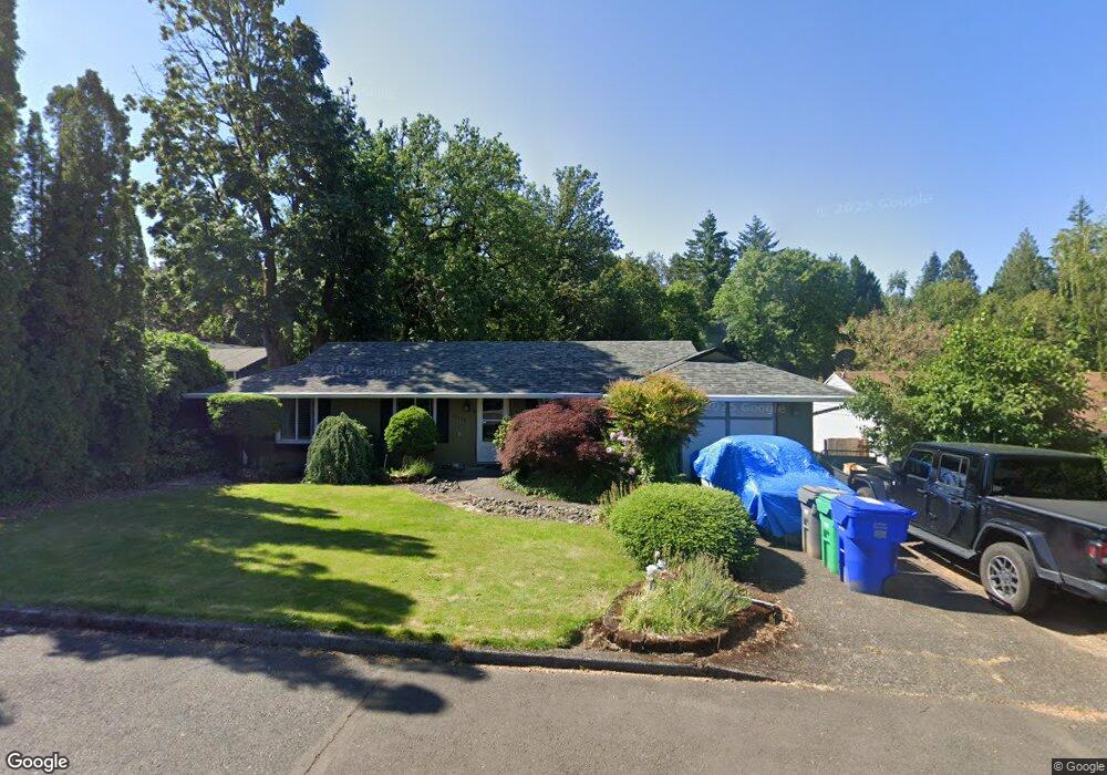
10138 SE Lexington St Portland, OR 97266
Lents NeighborhoodEstimated Value: $402,000 - $424,000
3
Beds
2
Baths
1,132
Sq Ft
$366/Sq Ft
Est. Value
About This Home
This home is located at 10138 SE Lexington St, Portland, OR 97266 and is currently estimated at $414,005, approximately $365 per square foot. 10138 SE Lexington St is a home located in Multnomah County with nearby schools including Kelly Elementary School, Lane Middle School, and Franklin High School.
Ownership History
Date
Name
Owned For
Owner Type
Purchase Details
Closed on
Jun 7, 2002
Sold by
Tropfenbaum James
Bought by
Melendez Jorge and Melendez Monica
Current Estimated Value
Home Financials for this Owner
Home Financials are based on the most recent Mortgage that was taken out on this home.
Original Mortgage
$140,829
Outstanding Balance
$59,630
Interest Rate
6.83%
Mortgage Type
FHA
Estimated Equity
$354,375
Purchase Details
Closed on
Mar 7, 2002
Sold by
Perlman David A
Bought by
Tropfenbaum James
Create a Home Valuation Report for This Property
The Home Valuation Report is an in-depth analysis detailing your home's value as well as a comparison with similar homes in the area
Home Values in the Area
Average Home Value in this Area
Purchase History
| Date | Buyer | Sale Price | Title Company |
|---|---|---|---|
| Melendez Jorge | $143,040 | Fidelity National Title Co | |
| Tropfenbaum James | $101,500 | Transnation Title Insurance |
Source: Public Records
Mortgage History
| Date | Status | Borrower | Loan Amount |
|---|---|---|---|
| Open | Melendez Jorge | $140,829 |
Source: Public Records
Tax History Compared to Growth
Tax History
| Year | Tax Paid | Tax Assessment Tax Assessment Total Assessment is a certain percentage of the fair market value that is determined by local assessors to be the total taxable value of land and additions on the property. | Land | Improvement |
|---|---|---|---|---|
| 2024 | $4,739 | $177,140 | -- | -- |
| 2023 | $4,558 | $171,990 | $0 | $0 |
| 2022 | $4,459 | $166,990 | $0 | $0 |
| 2021 | $4,384 | $162,130 | $0 | $0 |
| 2020 | $4,021 | $157,410 | $0 | $0 |
| 2019 | $3,874 | $152,830 | $0 | $0 |
| 2018 | $3,760 | $148,380 | $0 | $0 |
| 2017 | $3,603 | $144,060 | $0 | $0 |
| 2016 | $3,298 | $139,870 | $0 | $0 |
| 2015 | $2,800 | $135,800 | $0 | $0 |
| 2014 | $2,559 | $131,850 | $0 | $0 |
Source: Public Records
Map
Nearby Homes
- 7842 SE 103rd Ave
- 8002 SE 104th Ave
- 10639 SE Mount Scott Blvd
- 7702 SE 98th Ave
- 10722 SE Lexington St
- 9838 SE Clatsop St
- 10723 SE Henderson St
- 7630 SE 109th Ave
- 10945 SE Mount Scott Blvd
- 8512 SE Constance Dr
- 9631 SE Clatsop St
- 10211 SE Bristol Ln Unit 10211
- 8547 SE Constance Dr
- 9402 SE Tenino Ct
- 10148 SE Bristol Loop
- 8833 SE Bristol Park Dr
- 7212 SE Terrace Trails Dr
- 9330 SE Sun Crest Dr
- 9294 SE Middleton St
- 9280 SE Middleton St
- 10128 SE Lexington St
- 7905 SE 103rd Ave
- 7845 SE 103rd Ave
- 7911 SE 103rd Ave
- 7835 SE 103rd Ave
- 7910 SE 101st Ave
- 10116 SE Lexington St
- 7923 SE 103rd Ave
- 7827 SE 103rd Ave
- 10137 SE Lexington St
- 10123 SE Lexington St
- 7817 SE 103rd Ave
- 7941 SE 103rd Ave Unit C
- 7941 SE 103rd Ave
- 10111 SE Lexington St
- 7906 SE 103rd Ave
- 7809 SE 103rd Ave
- 7914 SE 103rd Ave
- 7834 SE 103rd Ave
- 10120 SE Malden St