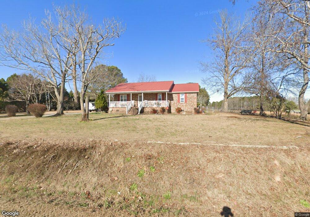
1014 Byrdtown Rd Benson, NC 27504
Elevation NeighborhoodEstimated Value: $288,000 - $309,000
3
Beds
2
Baths
1,345
Sq Ft
$223/Sq Ft
Est. Value
About This Home
This home is located at 1014 Byrdtown Rd, Benson, NC 27504 and is currently estimated at $299,970, approximately $223 per square foot. 1014 Byrdtown Rd is a home located in Johnston County with nearby schools including Benson Elementary School, Benson Middle School, and South Johnston High School.
Ownership History
Date
Name
Owned For
Owner Type
Purchase Details
Closed on
May 10, 2016
Sold by
Secretary Of Housing & Urban Development
Bought by
Williams Henry Michael and Williams Kim
Current Estimated Value
Home Financials for this Owner
Home Financials are based on the most recent Mortgage that was taken out on this home.
Original Mortgage
$81,500
Outstanding Balance
$63,999
Interest Rate
3.25%
Mortgage Type
Adjustable Rate Mortgage/ARM
Estimated Equity
$235,971
Purchase Details
Closed on
Sep 15, 2015
Sold by
Matrix Financial Services Corp
Bought by
Secretary Of Housing & Urban Development
Purchase Details
Closed on
Jul 23, 2015
Sold by
Mitchell Judy
Bought by
Matrix Financial Services Corp
Create a Home Valuation Report for This Property
The Home Valuation Report is an in-depth analysis detailing your home's value as well as a comparison with similar homes in the area
Home Values in the Area
Average Home Value in this Area
Purchase History
| Date | Buyer | Sale Price | Title Company |
|---|---|---|---|
| Williams Henry Michael | -- | None Available | |
| Secretary Of Housing & Urban Development | -- | None Available | |
| Matrix Financial Services Corp | $116,450 | None Available |
Source: Public Records
Mortgage History
| Date | Status | Borrower | Loan Amount |
|---|---|---|---|
| Open | Williams Henry Michael | $81,500 |
Source: Public Records
Tax History Compared to Growth
Tax History
| Year | Tax Paid | Tax Assessment Tax Assessment Total Assessment is a certain percentage of the fair market value that is determined by local assessors to be the total taxable value of land and additions on the property. | Land | Improvement |
|---|---|---|---|---|
| 2025 | $1,821 | $286,720 | $72,000 | $214,720 |
| 2024 | $1,178 | $145,460 | $34,200 | $111,260 |
| 2023 | $1,149 | $145,460 | $34,200 | $111,260 |
| 2022 | $1,207 | $145,460 | $34,200 | $111,260 |
| 2021 | $1,207 | $145,460 | $34,200 | $111,260 |
| 2020 | $1,251 | $145,460 | $34,200 | $111,260 |
| 2019 | $1,251 | $145,460 | $34,200 | $111,260 |
| 2018 | $1,076 | $122,320 | $27,000 | $95,320 |
| 2017 | $1,076 | $122,320 | $27,000 | $95,320 |
| 2016 | $1,076 | $122,320 | $27,000 | $95,320 |
| 2015 | $1,076 | $122,320 | $27,000 | $95,320 |
| 2014 | $1,076 | $122,320 | $27,000 | $95,320 |
Source: Public Records
Map
Nearby Homes
- 122 E American Marigold Dr
- 140 E American Marigold Dr
- 121 E American Marigold Dr
- 261 Kissington Way
- 259 E American Marigold Dr
- 292 Weddington Way
- 243 Kissington Way
- 271 White Azalea Way
- 104 E American Marigold Dr Unit 59
- 74 E American Marigold Dr Unit 61
- 75 E American Marigold Dr
- 75 E American Marigold Dr Unit 37
- 193 Kissington Way
- 85 Kissington Way
- 209 E American Marigold Dr Unit 44
- 209 E American Marigold Dr
- 200 Kissington Way
- 184 Kissington Way
- 33-80 White Azalea Way
- 69-81 White Azalea Way
- 431 Byrdtown Rd
- 1040 Byrdtown Rd
- 1084 Byrdtown Rd
- 1093 Byrdtown Rd
- 1093 Byrdtown Rd
- 1077 Byrdtown Rd
- 1050 Byrdtown Rd
- 1126 Byrdtown Rd
- 112 Family Ln
- 1119 Byrdtown Rd
- 1000 Byrdtown Rd
- 1121 Byrdtown Rd
- 1160 Byrdtown Rd
- 1160 Byrdtown Rd Unit 6
- 1173 Byrdtown Rd
- 1176 Byrdtown Rd
- 1193 Byrdtown Rd
- 1179 Byrdtown Rd
- 1188 Byrdtown Rd
- 142 Amy Dr