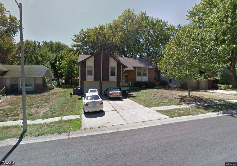
1014 Dunwich Dr Liberty, MO 64068
Estimated Value: $286,571 - $309,000
3
Beds
3
Baths
1,182
Sq Ft
$252/Sq Ft
Est. Value
About This Home
This home is located at 1014 Dunwich Dr, Liberty, MO 64068 and is currently estimated at $297,393, approximately $251 per square foot. 1014 Dunwich Dr is a home located in Clay County with nearby schools including Alexander Doniphan Elementary School, Liberty Middle School, and Liberty High School.
Ownership History
Date
Name
Owned For
Owner Type
Purchase Details
Closed on
Dec 14, 2012
Sold by
Circle J Enterprises Llc
Bought by
Barchers Otis L and Barchers Joy S
Current Estimated Value
Purchase Details
Closed on
Dec 26, 2002
Sold by
Barchers Dean H
Bought by
Barchers Otis L and Barchers Joy
Purchase Details
Closed on
Jul 10, 2001
Sold by
Lind Michael K and Lind Delia
Bought by
Barchers Otis L and Barchers Joy S
Home Financials for this Owner
Home Financials are based on the most recent Mortgage that was taken out on this home.
Original Mortgage
$92,800
Interest Rate
7.75%
Create a Home Valuation Report for This Property
The Home Valuation Report is an in-depth analysis detailing your home's value as well as a comparison with similar homes in the area
Home Values in the Area
Average Home Value in this Area
Purchase History
| Date | Buyer | Sale Price | Title Company |
|---|---|---|---|
| Barchers Otis L | -- | None Available | |
| Barchers Otis L | -- | 1St American | |
| Barchers Otis L | -- | Thomson Title Corp |
Source: Public Records
Mortgage History
| Date | Status | Borrower | Loan Amount |
|---|---|---|---|
| Previous Owner | Barchers Otis L | $92,800 |
Source: Public Records
Tax History Compared to Growth
Tax History
| Year | Tax Paid | Tax Assessment Tax Assessment Total Assessment is a certain percentage of the fair market value that is determined by local assessors to be the total taxable value of land and additions on the property. | Land | Improvement |
|---|---|---|---|---|
| 2025 | $2,471 | $36,920 | -- | -- |
| 2024 | $2,471 | $32,130 | -- | -- |
| 2023 | $2,513 | $32,130 | $0 | $0 |
| 2022 | $2,351 | $29,680 | $0 | $0 |
| 2021 | $2,333 | $29,678 | $7,220 | $22,458 |
| 2020 | $2,175 | $25,990 | $0 | $0 |
| 2019 | $2,175 | $25,992 | $5,510 | $20,482 |
| 2018 | $2,115 | $24,810 | $0 | $0 |
| 2017 | $2,007 | $24,810 | $4,560 | $20,250 |
| 2016 | $2,007 | $23,770 | $4,560 | $19,210 |
| 2015 | $2,007 | $23,770 | $4,560 | $19,210 |
| 2014 | $1,948 | $22,880 | $4,370 | $18,510 |
Source: Public Records
Map
Nearby Homes
- 1331 Park Ln
- 1317 Park Ln
- 1110 Canterbury Ln
- 1105 Bristol Way
- 918 Amesbury Ave
- 1218 Canterbury Ln
- 862 Amesbury Ave
- 1124 Amesbury Ave
- 1209 Liberty Drive Terrace
- 1304 Wellington Way
- 716 Bristol Ct
- 1327 Easton Ct
- 442 Circle Dr
- 1507 Amesbury Ave
- 1733 Welleslay Ln
- 1030 Maple Woods Dr
- 509 Belmont St
- 1025 Orchard Ave
- 1519 Trumpet Ct
- 828 W Brown St
- 1020 Dunwich Dr
- 1008 Dunwich Dr
- 1026 Dunwich Dr
- 1002 Dunwich Dr
- 1027 Essex St
- 1021 Essex St
- 1524 Oxford Ct
- 1032 Dunwich Dr
- 1033 Essex St
- 1015 Essex St
- 1023 Dunwich Dr
- 1038 Dunwich Dr
- 931 Dunwich Dr
- 1009 Essex St
- 934 Dunwich Dr
- 1518 Oxford Ct
- 1045 Essex St
- 1519 Oxford Ct
- 1025 Dunwich Dr
- 925 Dunwich Dr