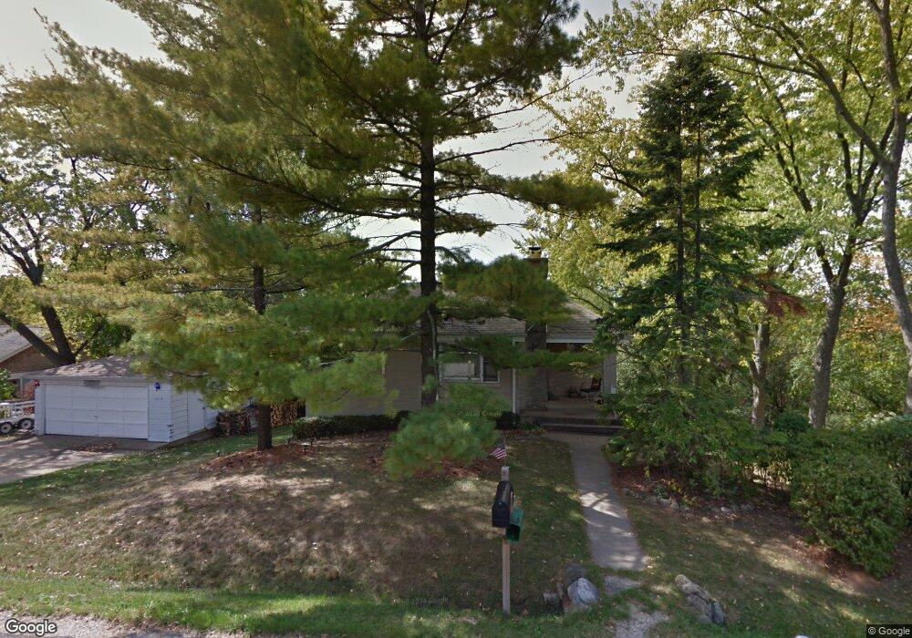
1014 Sheridan Dr Wauconda, IL 60084
Estimated Value: $216,152 - $266,000
2
Beds
2
Baths
716
Sq Ft
$328/Sq Ft
Est. Value
About This Home
This home is located at 1014 Sheridan Dr, Wauconda, IL 60084 and is currently estimated at $235,038, approximately $328 per square foot. 1014 Sheridan Dr is a home located in Lake County with nearby schools including Wauconda Grade School, Wauconda Middle School, and Wauconda High School.
Ownership History
Date
Name
Owned For
Owner Type
Purchase Details
Closed on
Jan 17, 2011
Sold by
Elbert Maurine A and Baird Maurine A
Bought by
Elbert John A
Current Estimated Value
Purchase Details
Closed on
Nov 28, 1994
Sold by
Norton Gregory P
Bought by
Elbert John A and Baird Maurine A
Home Financials for this Owner
Home Financials are based on the most recent Mortgage that was taken out on this home.
Original Mortgage
$97,429
Interest Rate
8.5%
Create a Home Valuation Report for This Property
The Home Valuation Report is an in-depth analysis detailing your home's value as well as a comparison with similar homes in the area
Home Values in the Area
Average Home Value in this Area
Purchase History
| Date | Buyer | Sale Price | Title Company |
|---|---|---|---|
| Elbert John A | -- | None Available | |
| Elbert John A | $105,000 | Chicago Title Insurance Co |
Source: Public Records
Mortgage History
| Date | Status | Borrower | Loan Amount |
|---|---|---|---|
| Closed | Elbert John A | $97,429 |
Source: Public Records
Tax History Compared to Growth
Tax History
| Year | Tax Paid | Tax Assessment Tax Assessment Total Assessment is a certain percentage of the fair market value that is determined by local assessors to be the total taxable value of land and additions on the property. | Land | Improvement |
|---|---|---|---|---|
| 2024 | $3,629 | $49,160 | $11,005 | $38,155 |
| 2023 | $4,118 | $44,936 | $10,059 | $34,877 |
| 2022 | $4,118 | $43,740 | $12,826 | $30,914 |
| 2021 | $3,911 | $41,330 | $12,119 | $29,211 |
| 2020 | $3,768 | $39,392 | $11,551 | $27,841 |
| 2019 | $3,332 | $37,229 | $10,917 | $26,312 |
| 2018 | $3,383 | $35,447 | $12,946 | $22,501 |
| 2017 | $3,378 | $35,037 | $12,796 | $22,241 |
| 2016 | $3,150 | $33,179 | $12,117 | $21,062 |
| 2015 | $2,925 | $30,459 | $11,124 | $19,335 |
| 2014 | $3,604 | $34,529 | $12,493 | $22,036 |
| 2012 | $3,536 | $36,866 | $11,951 | $24,915 |
Source: Public Records
Map
Nearby Homes
- 1260 Water Stone Cir
- 701 Lake Shore Dr
- 0 Bonner Rd
- 28722 N Madison Ave
- 419 Hill St Unit 2805
- 302 Stillwater Ct Unit 1702
- 303 Stillwater Ct Unit 1106
- 309 Stillwater Ct Unit 1101
- 28855 N Garland Rd
- 315 Hill St Unit A
- 28177 N Garland Rd
- 325 Sundown Ct Unit B
- 29564 N Garland Rd
- 310 Sundown Ct Unit E
- 26049 N Il Route 59
- 136 Parkview Dr Unit 5136
- 26241 W Bonner Rd
- 225 Regency Ct Unit A
- 107 Hammond Ave
- 235 Regency Ct Unit B
- 1016 Sheridan Dr
- 1015 Sheridan Dr
- 1017 Sheridan Dr
- 1018 Sheridan Dr
- 1019 Sheridan Dr
- 1019 Sheridan Dr Unit A
- 1006 Sheridan Dr
- 1019B Sheridan Dr
- 1001 Northshore Dr
- 995 Northshore Dr
- 1005 Northshore Dr
- 1016 Edward Place
- 1018 James St
- 1022 Sheridan Dr
- 1021 Sheridan Dr
- 1013 James St
- 985 Northshore Dr
- 1015 James St
- 1002 Sheridan Dr
- 1001 Sheridan Dr