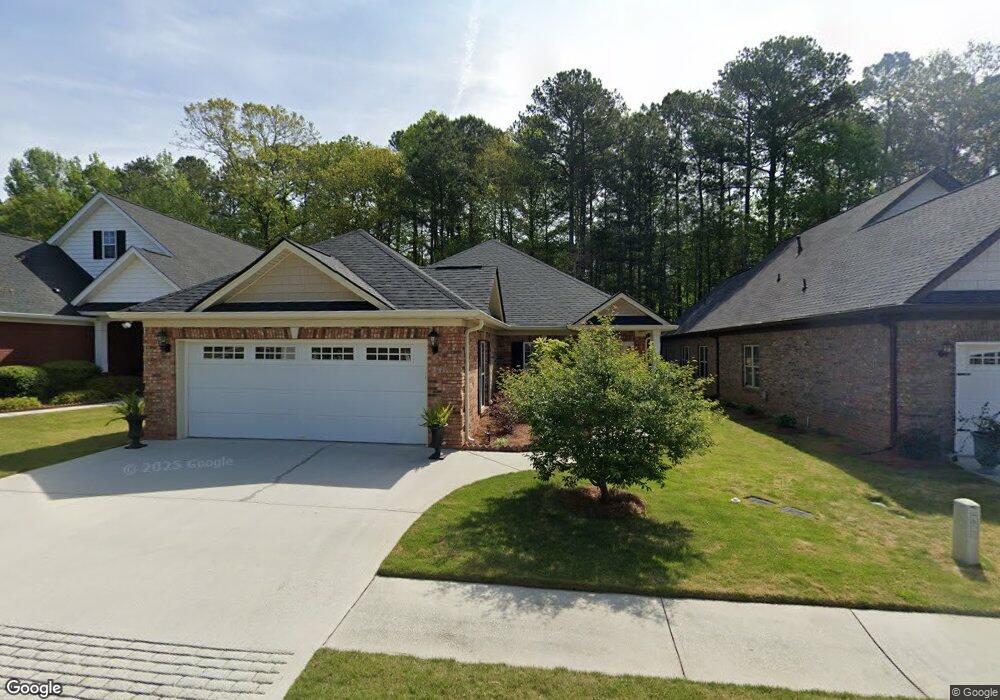
10143 Malcolm Dr Covington, GA 30014
Estimated Value: $381,681 - $421,000
Studio
2
Baths
2,628
Sq Ft
$152/Sq Ft
Est. Value
About This Home
This home is located at 10143 Malcolm Dr, Covington, GA 30014 and is currently estimated at $398,670, approximately $151 per square foot. 10143 Malcolm Dr is a home located in Newton County with nearby schools including Middle Ridge Elementary School, Cousins Middle School, and Eastside High School.
Ownership History
Date
Name
Owned For
Owner Type
Purchase Details
Closed on
Sep 30, 2019
Sold by
Capes Barbara O
Bought by
Carter Elizabeth W
Current Estimated Value
Purchase Details
Closed on
Oct 27, 2017
Sold by
Capes Jerry Oliver
Bought by
Capes Barbara Trustee and Capes Barbara Credit Shelter T
Purchase Details
Closed on
Apr 2, 2008
Sold by
Capes Jerry and Capes Barbara O
Bought by
Capes Jerry O and Capes Barbara O
Purchase Details
Closed on
Jul 14, 2006
Sold by
Freeman Builders Inc
Bought by
Capes Jerry and Capes Barbara
Create a Home Valuation Report for This Property
The Home Valuation Report is an in-depth analysis detailing your home's value as well as a comparison with similar homes in the area
Home Values in the Area
Average Home Value in this Area
Purchase History
| Date | Buyer | Sale Price | Title Company |
|---|---|---|---|
| Carter Elizabeth W | $275,000 | -- | |
| Capes Barbara Trustee | -- | -- | |
| Capes Jerry O | -- | -- | |
| Capes Jerry | $259,200 | -- |
Source: Public Records
Tax History
| Year | Tax Paid | Tax Assessment Tax Assessment Total Assessment is a certain percentage of the fair market value that is determined by local assessors to be the total taxable value of land and additions on the property. | Land | Improvement |
|---|---|---|---|---|
| 2025 | $3,914 | $171,520 | $20,000 | $151,520 |
| 2024 | $3,861 | $164,640 | $20,000 | $144,640 |
| 2023 | $3,884 | $145,680 | $12,800 | $132,880 |
| 2022 | $3,350 | $127,320 | $12,800 | $114,520 |
| 2021 | $3,293 | $115,000 | $12,800 | $102,200 |
| 2020 | $3,054 | $101,160 | $12,800 | $88,360 |
| 2019 | $4,087 | $100,600 | $12,800 | $87,800 |
| 2018 | $2,059 | $103,440 | $12,800 | $90,640 |
| 2017 | $3,926 | $98,800 | $12,800 | $86,000 |
| 2016 | $3,116 | $79,080 | $9,600 | $69,480 |
| 2015 | $3,039 | $77,120 | $8,000 | $69,120 |
| 2014 | $2,881 | $73,240 | $0 | $0 |
Source: Public Records
Map
Nearby Homes
- 10110 Malcolm Ct
- 10155 Malcolm Dr
- 10184 Malcolm Dr
- 8193 Monticello St
- 85 Bellerive Ln SE
- 130 S Links Dr
- 8 Jackson Rd
- 7703 Fawn Cir
- 7713 Fawn Cir Unit 51
- 7762 Fawn Cir
- 8239 High Lake Terrace SE
- 9187 Plantation Cir
- 0 Petty St Unit 10547316
- 0 Petty St Unit 7640177
- 7155 Petty St SW
- 8151 Puckett St SW
- 7120 Chaney Dr SW
- 6195 Petty St SW
- 8112 Puckett St SW
- 6175 Petty St SW
- 10149 Malcolm Dr
- 10139 Malcolm Dr
- 10104 Malcolm Ct
- 10159 Malcolm Dr
- 10144 Malcolm Dr Unit 58
- 10144 Malcolm Dr
- 10138 Malcolm Dr Unit 57
- 10138 Malcolm Dr
- 10112 Malcolm Ct
- 10154 Malcolm Dr
- 10163 Malcolm Dr
- 10158 Malcolm Dr
- 10158 Malcolm Dr Unit 61
- 10126 Malcolm Dr
- 10169 Malcolm Dr
- 10164 Malcolm Dr
- 10115 Malcolm Ct
- 10115 Malcom Ct
- 10120 Malcolm Dr Unit 126
- 10120 Malcolm Dr
Your Personal Tour Guide
Ask me questions while you tour the home.