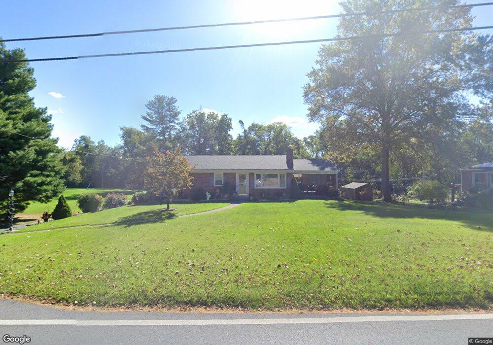
1015 Security Rd Hagerstown, MD 21742
Northeast Hagerstown NeighborhoodEstimated Value: $254,000 - $302,000
Studio
1
Bath
1,204
Sq Ft
$228/Sq Ft
Est. Value
About This Home
This home is located at 1015 Security Rd, Hagerstown, MD 21742 and is currently estimated at $274,621, approximately $228 per square foot. 1015 Security Rd is a home located in Washington County with nearby schools including Pangborn Elementary School, Otsego West Campus High School, and Northern Middle School.
Ownership History
Date
Name
Owned For
Owner Type
Purchase Details
Closed on
Oct 22, 2021
Sold by
Plume Harold L
Bought by
Plume Harold L and Plume Jacqueline L
Current Estimated Value
Purchase Details
Closed on
May 5, 2014
Sold by
Plume Alice Elizabeth
Bought by
Plume Harold L
Purchase Details
Closed on
Sep 25, 2013
Sold by
Plume Alice Elizabeth
Bought by
Plume Alice Elizabeth
Create a Home Valuation Report for This Property
The Home Valuation Report is an in-depth analysis detailing your home's value as well as a comparison with similar homes in the area
Home Values in the Area
Average Home Value in this Area
Purchase History
| Date | Buyer | Sale Price | Title Company |
|---|---|---|---|
| Plume Harold L | -- | None Available | |
| Plume Harold L | -- | None Available | |
| Plume Alice Elizabeth | -- | None Available |
Source: Public Records
Tax History Compared to Growth
Tax History
| Year | Tax Paid | Tax Assessment Tax Assessment Total Assessment is a certain percentage of the fair market value that is determined by local assessors to be the total taxable value of land and additions on the property. | Land | Improvement |
|---|---|---|---|---|
| 2025 | $1,776 | $203,900 | $0 | $0 |
| 2024 | $1,776 | $171,500 | $55,000 | $116,500 |
| 2023 | $1,686 | $162,800 | $0 | $0 |
| 2022 | $1,595 | $154,100 | $0 | $0 |
| 2021 | $1,534 | $145,400 | $55,000 | $90,400 |
| 2020 | $1,492 | $141,433 | $0 | $0 |
| 2019 | $1,457 | $137,467 | $0 | $0 |
| 2018 | $1,415 | $133,500 | $55,000 | $78,500 |
| 2017 | $1,415 | $133,500 | $0 | $0 |
| 2016 | -- | $133,500 | $0 | $0 |
| 2015 | $2,018 | $139,300 | $0 | $0 |
| 2014 | $2,018 | $139,300 | $0 | $0 |
Source: Public Records
Map
Nearby Homes
- 221 Sunbrook Ln Unit 73
- 526 Pangborn Blvd
- 80 Sunbrook Ln Unit 170
- 23 Atlantic Dr
- 1056 Valleybrook Dr
- 1001 Jefferson Blvd
- 1270 Jefferson Blvd
- 723 Medway Rd
- 713 Medway Rd
- 0 Jefferson Blvd Unit MDWA2032528
- 939 View St
- 232 E Irvin Ave
- 761 Jefferson Blvd
- 732 Jefferson Blvd
- 53 Mealey Pkwy
- 217 Mealey Pkwy
- 10 Carriage Hill Dr
- 808 Mulberry Ave
- 190 Brynwood St
- 823 Mulberry Ave
- 1005 Security Rd
- 1025 Security Rd
- 1001 Security Rd
- 1031 Security Rd
- 1034 Security Rd
- 1000 Security Rd
- 1039 Security Rd
- 950 Security Rd
- 1036 Security Rd
- 999A Security Rd
- 999 Security Rd
- 999 Security Rd
- 1043 Security Rd
- 1038 Security Rd
- 931 Security Rd
- 997 Security Rd
- 933 Security Rd
- 1040 Security Rd
- 1045 Security Rd
- 1042 Security Rd