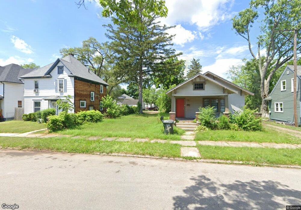
1015 Sherman Ave South Bend, IN 46616
Near Northwest NeighborhoodEstimated Value: $25,585 - $222,000
3
Beds
2
Baths
1,056
Sq Ft
$138/Sq Ft
Est. Value
About This Home
This home is located at 1015 Sherman Ave, South Bend, IN 46616 and is currently estimated at $145,646, approximately $137 per square foot. 1015 Sherman Ave is a home located in St. Joseph County with nearby schools including Muessel Primary Center, Clay Intermediate Center, and Jefferson Intermediate Traditional School.
Ownership History
Date
Name
Owned For
Owner Type
Purchase Details
Closed on
Oct 14, 2023
Sold by
Auditor Of St Joseph County
Bought by
Dean Shatwanna
Current Estimated Value
Purchase Details
Closed on
Oct 15, 2008
Sold by
Castle Alliance Llc
Bought by
Aequitas I Llc
Purchase Details
Closed on
Jun 19, 2008
Sold by
Green Safari Llc
Bought by
Castel Alliance Llc
Purchase Details
Closed on
Dec 22, 2006
Sold by
Nicholson David and Nicholson Kara
Bought by
Green Safari Llc
Create a Home Valuation Report for This Property
The Home Valuation Report is an in-depth analysis detailing your home's value as well as a comparison with similar homes in the area
Home Values in the Area
Average Home Value in this Area
Purchase History
| Date | Buyer | Sale Price | Title Company |
|---|---|---|---|
| Dean Shatwanna | $1,000 | None Listed On Document | |
| Aequitas I Llc | -- | Smartertitle.Com Llc | |
| Castel Alliance Llc | -- | Metropolitan Title In Llc | |
| Green Safari Llc | -- | Riverbend Title |
Source: Public Records
Tax History Compared to Growth
Tax History
| Year | Tax Paid | Tax Assessment Tax Assessment Total Assessment is a certain percentage of the fair market value that is determined by local assessors to be the total taxable value of land and additions on the property. | Land | Improvement |
|---|---|---|---|---|
| 2024 | $12,324 | $6,500 | $6,500 | -- |
| 2023 | $220 | $6,500 | $6,500 | $0 |
| 2022 | $221 | $6,500 | $6,500 | $0 |
| 2021 | $82 | $2,400 | $2,400 | $0 |
| 2020 | $43 | $1,800 | $1,800 | $0 |
| 2019 | $78 | $1,800 | $1,800 | $0 |
| 2018 | $85 | $1,800 | $1,800 | $0 |
| 2017 | $45 | $1,800 | $1,800 | $0 |
| 2016 | $86 | $1,800 | $1,800 | $0 |
| 2014 | $1,221 | $46,700 | $2,100 | $44,600 |
Source: Public Records
Map
Nearby Homes
- 1052 Portage Ave
- 715 Blaine Ave
- 745 Allen St
- 1116 Allen St
- 1040 Woodward Ave
- 1201 Allen St
- 1111 Lindsey St
- 1102 Diamond Ave
- 918 Leland Ave Unit 918 & 920 Leland Ave
- 901 Lawndale St
- 611 Blaine Ave
- 1209 Poplar St
- 1253 Diamond Ave
- 836 Forest Ave
- 524 Euclid Ave
- 1514 Van Buren St
- 529 Euclid Ave
- 661 Lawndale Ave
- 617 N Walnut St
- 1428 Marigold Way Unit 111
- 1013 Sherman Ave
- 1017 Sherman Ave
- 1021 Sherman Ave
- 1023 Sherman Ave
- 1018 Allen St
- 1022 Allen St
- 1025 Sherman Ave
- 1014 Allen St
- 1010 Allen St
- 1020 Sherman Ave
- 1003 Sherman Ave
- 1007 Sherman Ave
- 1024 Allen St
- 1037 California Ave
- 1014 Sherman Ave
- 1018 Sherman Ave
- 1029 Sherman Ave
- 1012 Sherman Ave
- 1022 Sherman Ave
- 1023 California Ave