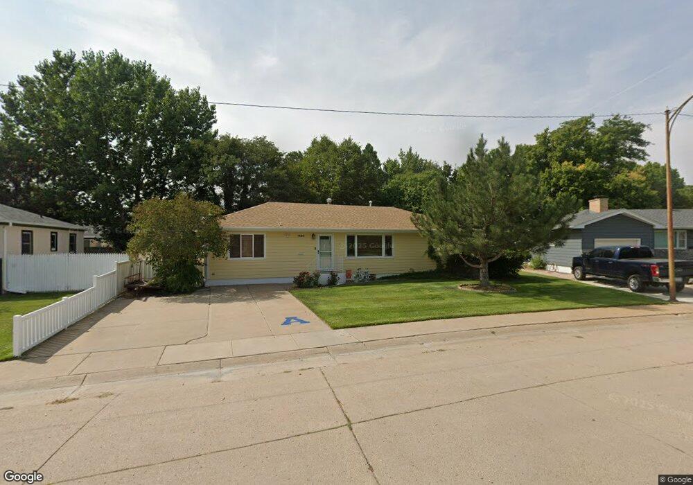
1016 Colorado Ave Alliance, NE 69301
Estimated Value: $124,000 - $195,022
1
Bed
2
Baths
1,296
Sq Ft
$135/Sq Ft
Est. Value
About This Home
This home is located at 1016 Colorado Ave, Alliance, NE 69301 and is currently estimated at $175,006, approximately $135 per square foot. 1016 Colorado Ave is a home located in Box Butte County with nearby schools including Alliance High School, St. Agnes Academy, and Immanuel Evangelical Lutheran School.
Ownership History
Date
Name
Owned For
Owner Type
Purchase Details
Closed on
Apr 1, 2019
Sold by
Stabnow Kalomera M
Bought by
Carlyle Smith and Smith Margaret
Current Estimated Value
Purchase Details
Closed on
Jul 27, 2012
Sold by
Stabnow Irving J and Stabnow Kalomera M
Bought by
Lynch Liesa M and Stabnow Mark I
Purchase Details
Closed on
May 21, 2007
Sold by
Dobrovolny Leo P
Bought by
Stabnow Irving J and Stabnow Kalomera M
Create a Home Valuation Report for This Property
The Home Valuation Report is an in-depth analysis detailing your home's value as well as a comparison with similar homes in the area
Home Values in the Area
Average Home Value in this Area
Purchase History
| Date | Buyer | Sale Price | Title Company |
|---|---|---|---|
| Carlyle Smith | $150,000 | -- | |
| Lynch Liesa M | -- | -- | |
| Stabnow Irving J | -- | Kunzman Title |
Source: Public Records
Tax History Compared to Growth
Tax History
| Year | Tax Paid | Tax Assessment Tax Assessment Total Assessment is a certain percentage of the fair market value that is determined by local assessors to be the total taxable value of land and additions on the property. | Land | Improvement |
|---|---|---|---|---|
| 2024 | $2,035 | $162,466 | $10,526 | $151,940 |
| 2023 | $2,793 | $162,466 | $10,526 | $151,940 |
| 2022 | $1,624 | $112,093 | $9,473 | $102,620 |
| 2021 | $1,941 | $105,283 | $9,473 | $95,810 |
| 2020 | $1,935 | $105,283 | $9,473 | $95,810 |
| 2019 | $1,698 | $94,568 | $9,473 | $85,095 |
| 2018 | $0 | $94,568 | $9,473 | $85,095 |
| 2017 | $1,773 | $95,517 | $8,947 | $86,570 |
| 2016 | $1,589 | $95,515 | $8,945 | $86,570 |
| 2015 | $79 | $90,615 | $8,945 | $81,670 |
| 2014 | $79 | $90,617 | $8,947 | $81,670 |
Source: Public Records
Map
Nearby Homes
- 1021 Dakota Ave
- 936 Platte Ave
- 819 Black Hills Ave
- 911 Emerson Ave
- 907 Toluca Ave
- 924 Big Horn Ave
- 1239 Toluca Ave
- 621 Emerson Ave
- 719 Toluca Ave
- 1232 Cheyenne Ave
- 904 Laramie Ave
- 1019 Laramie Ave
- 316 Big Horn Ave
- 20th St Emerson Ave To Colorado Ave
- 672 W 20th St
- 420 Laramie Ave
- 615 Sweetwater Ave
- 1004 Missouri Ave
- 917 Missouri Ave
- 2039 Niobrara Ave
- 1010 Colorado Ave
- 1022 Colorado Ave
- 1030 Colorado Ave
- 1015 Colorado Ave
- 1027 Dakota Ave
- 916 W 10th St Unit ALLIANCE, NE
- 1011 Colorado Ave
- 908 W 10th St
- 1023 Colorado Ave
- 1031 Dakota Ave
- 1003 Colorado Ave
- 1034 Colorado Ave
- 1024 Black Hills Ave
- 1016 Black Hills Ave
- 1039 Dakota Ave
- 1010 Black Hills Ave
- 740 W 11th St
- 928 Colorado Ave
- 1016 Dakota Ave
- 1042 Colorado Ave