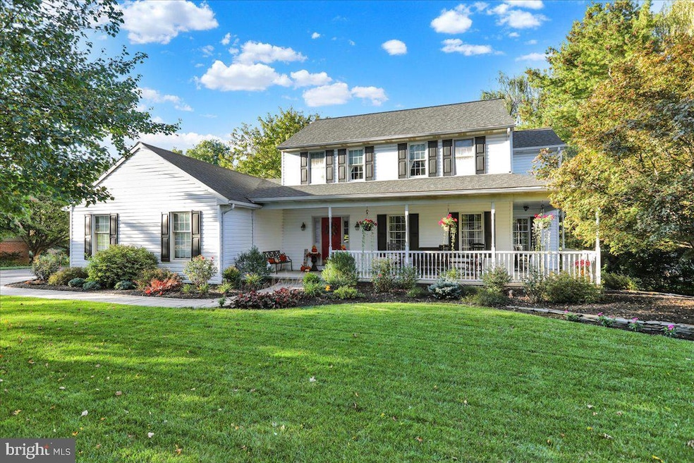

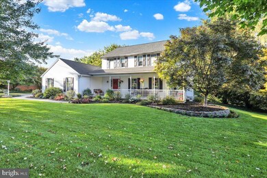


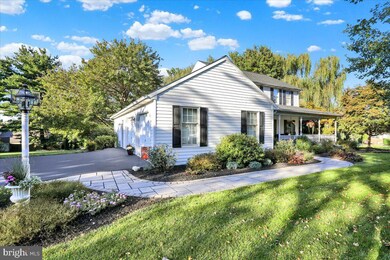
1016 Keystone Dr Lancaster, PA 17603
Blue Rock NeighborhoodEstimated payment $3,396/month
Highlights
- Colonial Architecture
- Vaulted Ceiling
- No HOA
- Central Manor Elementary School Rated A-
- 1 Fireplace
- 2 Car Attached Garage
About This Home
Welcome to this beautifully maintained single-family home nestled on a half-acre lot in the highly sought-after Penn Manor School District. This inviting property offers both comfort and convenience, with easy access to Lancaster City, Millersville University, and Route 30—perfect for commuting, shopping, and dining. Step inside to discover four spacious bedrooms and 2.5 bathrooms, providing plenty of room for family and guests. The bonus family room features a stunning vaulted ceiling and a cozy fireplace, creating the perfect space for relaxing or entertaining. A fully finished day light basement adds even more living space, ideal for a game room, home office, or gym. Outside, enjoy the peaceful surroundings from your deck or wrap around porch, and ample yard space, perfect for gardening or entertaining. This home has been lovingly cared for and maintained featuring a new roof, new siding, and a new driveway. Don’t miss your chance to see this one — call today to schedule your private showing!
Listing Agent
(717) 371-2540 priscillahomesale@gmail.com Coldwell Banker Realty Listed on: 10/22/2025

Home Details
Home Type
- Single Family
Est. Annual Taxes
- $6,024
Year Built
- Built in 1991
Lot Details
- 0.5 Acre Lot
- Property is in excellent condition
Parking
- 2 Car Attached Garage
- 6 Driveway Spaces
- Oversized Parking
- Side Facing Garage
- Garage Door Opener
Home Design
- Colonial Architecture
- Block Foundation
- Frame Construction
- Shingle Roof
- Vinyl Siding
Interior Spaces
- Property has 2.5 Levels
- Vaulted Ceiling
- 1 Fireplace
- Finished Basement
Bedrooms and Bathrooms
- 4 Bedrooms
Accessible Home Design
- Level Entry For Accessibility
Utilities
- Forced Air Heating and Cooling System
- Heat Pump System
- Heating System Powered By Leased Propane
- 200+ Amp Service
- Propane
- Well
- Electric Water Heater
- Cable TV Available
Community Details
- No Home Owners Association
- Shadowstone North Subdivision
Listing and Financial Details
- Assessor Parcel Number 410-97455-0-0000
Map
Home Values in the Area
Average Home Value in this Area
Tax History
| Year | Tax Paid | Tax Assessment Tax Assessment Total Assessment is a certain percentage of the fair market value that is determined by local assessors to be the total taxable value of land and additions on the property. | Land | Improvement |
|---|---|---|---|---|
| 2025 | $5,636 | $258,100 | $74,300 | $183,800 |
| 2024 | $5,636 | $258,100 | $74,300 | $183,800 |
| 2023 | $5,636 | $258,100 | $74,300 | $183,800 |
| 2022 | $5,530 | $258,100 | $74,300 | $183,800 |
| 2021 | $5,389 | $258,100 | $74,300 | $183,800 |
| 2020 | $5,389 | $258,100 | $74,300 | $183,800 |
| 2019 | $5,240 | $258,100 | $74,300 | $183,800 |
| 2018 | $4,113 | $258,100 | $74,300 | $183,800 |
| 2017 | $4,654 | $191,800 | $57,800 | $134,000 |
| 2016 | $4,654 | $191,800 | $57,800 | $134,000 |
| 2015 | $958 | $191,800 | $57,800 | $134,000 |
| 2014 | $3,259 | $191,800 | $57,800 | $134,000 |
Property History
| Date | Event | Price | List to Sale | Price per Sq Ft |
|---|---|---|---|---|
| 10/28/2025 10/28/25 | Pending | -- | -- | -- |
| 10/22/2025 10/22/25 | For Sale | $550,000 | -- | $188 / Sq Ft |
Purchase History
| Date | Type | Sale Price | Title Company |
|---|---|---|---|
| Deed | $189,200 | First American Title Ins Co |
Mortgage History
| Date | Status | Loan Amount | Loan Type |
|---|---|---|---|
| Open | $179,740 | No Value Available |
Source: Bright MLS
MLS Number: PALA2078396
APN: 410-97455-0-0000
Disclaimer: Certain information contained herein is derived from information provided by parties other than Homes.com. All information provided is deemed reliable, but is not guaranteed to be accurate and should be independently verified.
![]() The data relating to real estate for sale on this website appears in part through the BRIGHT Internet Data Exchange program, a voluntary cooperative exchange of property listing data between licensed real estate brokerage firms, and is provided by BRIGHT through a licensing agreement.
The data relating to real estate for sale on this website appears in part through the BRIGHT Internet Data Exchange program, a voluntary cooperative exchange of property listing data between licensed real estate brokerage firms, and is provided by BRIGHT through a licensing agreement.
Listing information is from various brokers who participate in the Bright MLS IDX program and not all listings may be visible on the site.
The property information being provided on or through the website is for the personal, non-commercial use of consumers and such information may not be used for any purpose other than to identify prospective properties consumers may be interested in purchasing.
Some properties which appear for sale on the website may no longer be available because they are for instance, under contract, sold or are no longer being offered for sale.
Property information displayed is deemed reliable but is not guaranteed.
Copyright 2025 Bright MLS, Inc.
- 1027 Keystone Dr
- 1077 Monticello Ln
- 204 Scarborough Ln
- 1053 Williamsburg Rd
- 12 Knollwood Rd
- 30 Oakgrove Ln
- 53 Knollwood Rd
- 249 Letort Rd
- 39 Manor Oaks Dr
- 352 Knollwood Rd
- 109 Village Dr
- Sloane II Plan at Wynfield at Millersville
- Colton II Plan at Wynfield at Millersville
- 102 Village Dr
- Adalee Plan at Wynfield at Millersville
- 105 Village Dr
- 32 S Duke St
- 31 S Duke St
- 2205 Berkshire Rd
- 126 Broadstone St