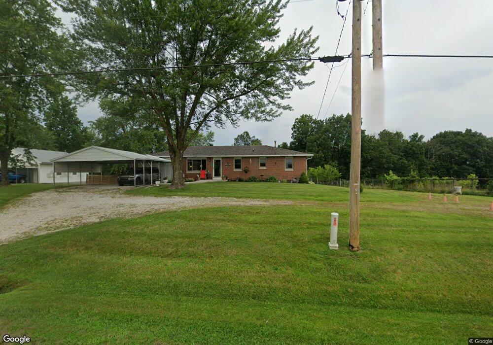
10165 Old Us Highway 54 New Bloomfield, MO 65063
Estimated Value: $185,834 - $325,000
--
Bed
1
Bath
1,288
Sq Ft
$182/Sq Ft
Est. Value
About This Home
This home is located at 10165 Old Us Highway 54, New Bloomfield, MO 65063 and is currently estimated at $234,209, approximately $181 per square foot. 10165 Old Us Highway 54 is a home located in Callaway County with nearby schools including New Bloomfield Elementary School and New Bloomfield High School.
Ownership History
Date
Name
Owned For
Owner Type
Purchase Details
Closed on
Sep 16, 2010
Sold by
Beneficial Mortgage Co
Bought by
Sanord Sheila R
Current Estimated Value
Purchase Details
Closed on
Jul 13, 2006
Sold by
Federal National Mortgage Association
Bought by
Williams Meri and Williams Tracy
Purchase Details
Closed on
Mar 24, 2005
Sold by
Mckim Charles N and Mckim Betty Ann
Bought by
Gray Joseph and Gray Elizabeth
Home Financials for this Owner
Home Financials are based on the most recent Mortgage that was taken out on this home.
Original Mortgage
$115,000
Interest Rate
5.67%
Mortgage Type
New Conventional
Create a Home Valuation Report for This Property
The Home Valuation Report is an in-depth analysis detailing your home's value as well as a comparison with similar homes in the area
Home Values in the Area
Average Home Value in this Area
Purchase History
| Date | Buyer | Sale Price | Title Company |
|---|---|---|---|
| Sanord Sheila R | -- | -- | |
| Williams Meri | -- | None Available | |
| Gray Joseph | -- | -- |
Source: Public Records
Mortgage History
| Date | Status | Borrower | Loan Amount |
|---|---|---|---|
| Previous Owner | Gray Joseph | $115,000 |
Source: Public Records
Tax History Compared to Growth
Tax History
| Year | Tax Paid | Tax Assessment Tax Assessment Total Assessment is a certain percentage of the fair market value that is determined by local assessors to be the total taxable value of land and additions on the property. | Land | Improvement |
|---|---|---|---|---|
| 2024 | $1,016 | $17,942 | $0 | $0 |
| 2023 | $1,016 | $16,802 | $0 | $0 |
| 2022 | $949 | $16,802 | $701 | $16,101 |
| 2021 | $950 | $16,802 | $701 | $16,101 |
| 2020 | $950 | $16,802 | $701 | $16,101 |
| 2019 | $930 | $16,802 | $701 | $16,101 |
| 2018 | $934 | $16,802 | $701 | $16,101 |
| 2017 | $932 | $16,802 | $701 | $16,101 |
| 2016 | $788 | $14,170 | $0 | $0 |
| 2015 | $783 | $14,170 | $0 | $0 |
| 2014 | $788 | $14,170 | $0 | $0 |
Source: Public Records
Map
Nearby Homes
- 10407 County Road 497
- 10431 County Road 497
- 2943 State Road Tt
- 133 Manview Ln
- 2962 County Road 496
- 231 Elm Ave
- 10879 Country Aire Meadows Ct
- 10884 Country Aire Meadows Ct
- 10890 Country Aire Meadows Ct
- 10896 Country Aire Meadows Ct
- 57 Kirk Dr
- 63 Kirk Dr
- 65 Kirk Dr
- 56 Kirk Dr
- 64 Kirk Dr
- 55 Kirk Dr
- 54 Kirk Dr
- LOT 7 Eagle View Spur
- LOT 6 Eagle View Spur
- LOT 8 Eagle Lake Ln
- 10173 Old Us Highway 54
- TBD Old Us Hwy 54
- 10189 Old Us Highway 54
- 2501 County Road 370
- 10170 County Road 367
- 10225 Old Us Highway 54
- 0 County Road 370
- 10230 Old Us Highway 54
- 2495 County Road 370
- TBD LOT 6 County Road 367
- 10135 County Road 367
- 2494 County Road 370
- 2494 County Road 370
- 2482 County Road 370
- 10123 County Road 367
- 10232 Old Us Highway 54
- 10233 Old Us Highway 54
- 10105 County Road 367
- 10255 Old Us Highway 54
- TBD LOT 5 County Road 367