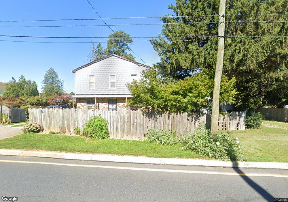
1017 Grofftown Rd Lancaster, PA 17602
Conestoga Woods NeighborhoodEstimated Value: $145,305 - $250,000
2
Beds
1
Bath
576
Sq Ft
$333/Sq Ft
Est. Value
About This Home
This home is located at 1017 Grofftown Rd, Lancaster, PA 17602 and is currently estimated at $191,576, approximately $332 per square foot. 1017 Grofftown Rd is a home located in Lancaster County with nearby schools including Burrowes Elementary School, Wickersham Elementary School, and Lincoln Middle School.
Ownership History
Date
Name
Owned For
Owner Type
Purchase Details
Closed on
Sep 19, 2001
Sold by
Wiley Mabel and Detwiler Glenn M
Bought by
Lam Loan T
Current Estimated Value
Home Financials for this Owner
Home Financials are based on the most recent Mortgage that was taken out on this home.
Original Mortgage
$57,450
Outstanding Balance
$22,386
Interest Rate
6.98%
Estimated Equity
$169,190
Create a Home Valuation Report for This Property
The Home Valuation Report is an in-depth analysis detailing your home's value as well as a comparison with similar homes in the area
Home Values in the Area
Average Home Value in this Area
Purchase History
| Date | Buyer | Sale Price | Title Company |
|---|---|---|---|
| Lam Loan T | $60,500 | -- |
Source: Public Records
Mortgage History
| Date | Status | Borrower | Loan Amount |
|---|---|---|---|
| Open | Lam Loan T | $57,450 |
Source: Public Records
Tax History
| Year | Tax Paid | Tax Assessment Tax Assessment Total Assessment is a certain percentage of the fair market value that is determined by local assessors to be the total taxable value of land and additions on the property. | Land | Improvement |
|---|---|---|---|---|
| 2025 | $1,229 | $56,800 | $25,100 | $31,700 |
| 2024 | $1,229 | $56,800 | $25,100 | $31,700 |
| 2023 | $1,197 | $56,800 | $25,100 | $31,700 |
| 2022 | $1,177 | $56,800 | $25,100 | $31,700 |
| 2021 | $1,151 | $56,800 | $25,100 | $31,700 |
| 2020 | $1,151 | $56,800 | $25,100 | $31,700 |
| 2019 | $1,139 | $56,800 | $25,100 | $31,700 |
| 2018 | $750 | $56,800 | $25,100 | $31,700 |
| 2017 | $1,651 | $64,900 | $21,200 | $43,700 |
| 2016 | $1,651 | $64,900 | $21,200 | $43,700 |
| 2015 | $415 | $64,900 | $21,200 | $43,700 |
| 2014 | $1,102 | $64,900 | $21,200 | $43,700 |
Source: Public Records
Map
Nearby Homes
- 153 N Broad St
- 1015 E Walnut St
- 819 E Marion St
- 980 E Orange St
- 309 N Reservoir St
- 319 N Reservoir St
- 312 N Reservoir St
- 911 E King St
- 717 E Walnut St
- 623 E Chestnut St
- 627 E Madison St
- 249 N Marshall St
- 610 E Madison St
- 1036 E King St
- 522 E Orange St
- 53 S Marshall St
- 762 New Holland Ave
- 121 S Marshall St
- 47 Riverside Ave
- 350 E Chestnut St
- 1013 Grofftown Rd
- 1021 Grofftown Rd
- 924 E Fulton St
- 1025 Grofftown Rd
- 922 E Fulton St
- 920 E Fulton St
- 1000 Grofftown Rd
- 1000 Grofftown Rd
- 921 E Chestnut St
- 918 E Fulton St
- 916 E Fulton St
- 913 E Chestnut St
- 931 E Fulton St
- 929 E Fulton St
- 933 E Fulton St
- 927 E Fulton St
- 935 E Fulton St
- 914 E Fulton St
- 911 E Chestnut St
- 937 E Fulton St
Your Personal Tour Guide
Ask me questions while you tour the home.