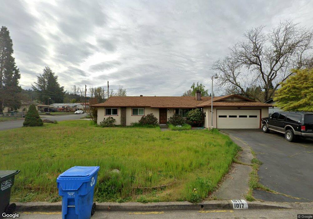
1017 Omaha Dr Grants Pass, OR 97527
Estimated Value: $352,000 - $365,197
3
Beds
2
Baths
1,356
Sq Ft
$264/Sq Ft
Est. Value
About This Home
This home is located at 1017 Omaha Dr, Grants Pass, OR 97527 and is currently estimated at $358,599, approximately $264 per square foot. 1017 Omaha Dr is a home located in Josephine County with nearby schools including Allen Dale Elementary School, South Middle School, and Grants Pass High School.
Ownership History
Date
Name
Owned For
Owner Type
Purchase Details
Closed on
Nov 14, 2018
Sold by
Ashley Kimberly J and Barnes Amber R
Bought by
Reynolds Robin K
Current Estimated Value
Purchase Details
Closed on
Oct 19, 2010
Sold by
Barnes Pauline M
Bought by
Barnes Pauline M and The Pauline M Barnes Living Trust
Purchase Details
Closed on
Mar 10, 2010
Sold by
Barnes Pauline M
Bought by
Barnes Pauline M
Purchase Details
Closed on
Jan 20, 2010
Sold by
Rose Diana
Bought by
Deutsche Bank National Trust Company
Create a Home Valuation Report for This Property
The Home Valuation Report is an in-depth analysis detailing your home's value as well as a comparison with similar homes in the area
Home Values in the Area
Average Home Value in this Area
Purchase History
| Date | Buyer | Sale Price | Title Company |
|---|---|---|---|
| Reynolds Robin K | -- | None Available | |
| Barnes Pauline M | -- | None Available | |
| Barnes Pauline M | -- | None Available | |
| Deutsche Bank National Trust Company | $105,300 | Accommodation |
Source: Public Records
Tax History Compared to Growth
Tax History
| Year | Tax Paid | Tax Assessment Tax Assessment Total Assessment is a certain percentage of the fair market value that is determined by local assessors to be the total taxable value of land and additions on the property. | Land | Improvement |
|---|---|---|---|---|
| 2025 | $2,464 | $189,730 | -- | -- |
| 2024 | $2,464 | $184,210 | -- | -- |
| 2023 | $2,321 | $178,850 | $0 | $0 |
| 2022 | $2,332 | $173,650 | -- | -- |
| 2021 | $2,190 | $168,600 | $0 | $0 |
| 2020 | $2,127 | $163,690 | $0 | $0 |
| 2019 | $2,066 | $158,930 | $0 | $0 |
| 2018 | $2,102 | $154,310 | $0 | $0 |
| 2017 | $2,086 | $149,820 | $0 | $0 |
| 2016 | $1,830 | $145,460 | $0 | $0 |
| 2015 | $1,719 | $141,230 | $0 | $0 |
| 2014 | $1,717 | $139,090 | $0 | $0 |
Source: Public Records
Map
Nearby Homes
- 1048 W Harbeck Rd
- 1010 Hemlock Ln
- 855 SW West Harbeck Rd
- 1969 SW Allen Creek Rd
- 1830 SW Allen Creek Rd
- 1762 SW Allen Creek Rd
- 0 Ramsey Southwest Ave SW Unit 220201654
- 1346 Sunny Slope Dr
- 109 Shoemaker Way
- 681 W Harbeck Rd
- 2957 Sylvan Dr
- 15577 Oregon 238
- 0 Sylvan Dr Unit Lot 10 220196204
- 1318 Andy Griffith Dr
- 1382 Andy Griffith Dr
- 214 SE Sapphire Ct
- 1444 Barney Fife Blvd
- 2704 Denton Trail
- 2708 Denton Trail
- 2700 Denton Trail
- 1033 Omaha Dr
- 1924 Nebraska Ave
- 1903 Nebraska Ave
- 1016 Omaha Dr
- 1919 Nebraska Ave
- 1055 Omaha Dr
- 1887 Nebraska Ave
- 1013 Aspen Way
- 1025 Aspen Way
- 1950 Nebraska Ave
- 2023 McCarter Ln
- 1953 Nebraska Ave
- 1001 Aspen Way
- 1920 Colorado Ln
- 1037 Aspen Way
- 1910 Colorado Ln
- 1071 Omaha Dr
- 1030 W Harbeck Rd
- 1940 Colorado Ln
- 2017 McCarter Ln