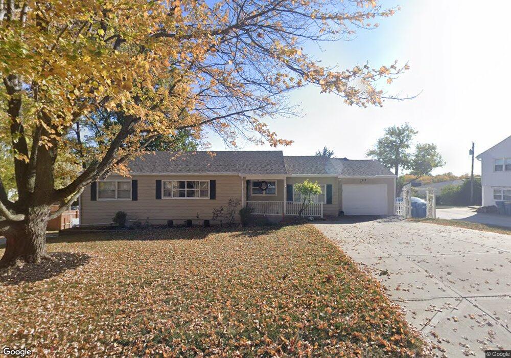
1017 Orchard Ave Liberty, MO 64068
Estimated Value: $255,000 - $314,000
3
Beds
2
Baths
1,412
Sq Ft
$195/Sq Ft
Est. Value
About This Home
This home is located at 1017 Orchard Ave, Liberty, MO 64068 and is currently estimated at $275,122, approximately $194 per square foot. 1017 Orchard Ave is a home located in Clay County with nearby schools including Ridgeview Elementary School, Heritage Middle School, and Liberty North High School.
Ownership History
Date
Name
Owned For
Owner Type
Purchase Details
Closed on
Jan 20, 2012
Sold by
Hughes Russell E and Malo Anita K
Bought by
Hughes Russell E and Malo Anita K
Current Estimated Value
Purchase Details
Closed on
Jun 23, 2011
Sold by
Stewart Colleen Nelson
Bought by
Malo Anita
Home Financials for this Owner
Home Financials are based on the most recent Mortgage that was taken out on this home.
Original Mortgage
$100,747
Outstanding Balance
$69,028
Interest Rate
4.5%
Mortgage Type
FHA
Estimated Equity
$206,094
Purchase Details
Closed on
Dec 8, 2010
Sold by
Karr John
Bought by
Stewart Colleen Nelson
Purchase Details
Closed on
Oct 28, 2005
Sold by
Karr Dawn
Bought by
Karr John and Karr John W
Purchase Details
Closed on
Dec 6, 1999
Sold by
Crow Bernice L
Bought by
Karr John
Create a Home Valuation Report for This Property
The Home Valuation Report is an in-depth analysis detailing your home's value as well as a comparison with similar homes in the area
Home Values in the Area
Average Home Value in this Area
Purchase History
| Date | Buyer | Sale Price | Title Company |
|---|---|---|---|
| Hughes Russell E | -- | None Available | |
| Hughes Russell E | -- | None Available | |
| Malo Anita | -- | Stewart Title Company | |
| Stewart Colleen Nelson | -- | None Available | |
| Karr John | -- | -- | |
| Karr John | -- | -- |
Source: Public Records
Mortgage History
| Date | Status | Borrower | Loan Amount |
|---|---|---|---|
| Open | Malo Anita | $100,747 |
Source: Public Records
Tax History Compared to Growth
Tax History
| Year | Tax Paid | Tax Assessment Tax Assessment Total Assessment is a certain percentage of the fair market value that is determined by local assessors to be the total taxable value of land and additions on the property. | Land | Improvement |
|---|---|---|---|---|
| 2025 | $2,507 | $37,450 | -- | -- |
| 2024 | $2,507 | $32,590 | -- | -- |
| 2023 | $2,549 | $32,590 | $0 | $0 |
| 2022 | $2,342 | $29,560 | $0 | $0 |
| 2021 | $2,323 | $29,564 | $3,610 | $25,954 |
| 2020 | $2,371 | $28,330 | $0 | $0 |
| 2019 | $2,371 | $28,330 | $0 | $0 |
| 2018 | $1,953 | $22,910 | $0 | $0 |
| 2017 | $1,935 | $22,910 | $3,230 | $19,680 |
| 2016 | $1,935 | $22,910 | $3,230 | $19,680 |
| 2015 | $1,935 | $22,910 | $3,230 | $19,680 |
| 2014 | $1,917 | $22,510 | $3,230 | $19,280 |
Source: Public Records
Map
Nearby Homes
- 1025 Orchard Ave
- 1209 Liberty Drive Terrace
- 194 Camelot Dr
- 605 Reed St
- 15 Valley Rd
- 1317 Park Ln
- 116 Dorsey St
- 324 Harrison St
- 1331 Park Ln
- 506 W Mississippi St
- 417 Locust St
- 716 Bristol Ct
- 815 Kings Ridge
- 412 N Fairview Ave
- 523 Lancelot Dr
- 527 Lancelot Dr
- 862 Amesbury Ave
- 918 Amesbury Ave
- 17 Main Ct
- 977 Wellington Way
- 1001 Orchard Ave
- 1001 Middlebrook Dr
- 1037 Orchard Ave
- 1016 Orchard Ave
- 1024 Orchard Ave
- 1002 Orchard Ave
- 1039 Orchard Ave
- 1034 Orchard Ave
- 400 Cherokee Dr
- 1103 Orchard Ave
- 312 Range Line Rd
- 315 S Clayview Dr
- 1015 Elizabeth St
- 324 S Clayview Dr
- 1111 Orchard Ave
- 305 S Clayview Dr
- 601 S State Route 291
- 1110 Orchard Ave
- 316 S Clayview Dr
- 409 Cherokee Dr