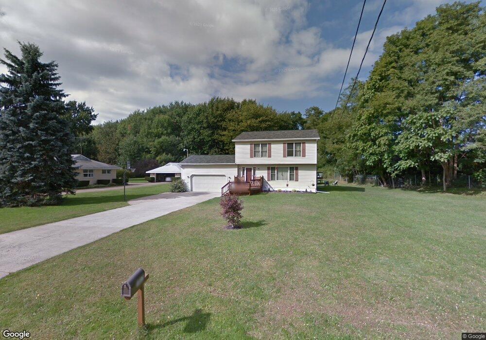
1017 Park Rd Painesville, OH 44077
Estimated Value: $222,000 - $299,000
3
Beds
4
Baths
1,020
Sq Ft
$263/Sq Ft
Est. Value
About This Home
This home is located at 1017 Park Rd, Painesville, OH 44077 and is currently estimated at $268,670, approximately $263 per square foot. 1017 Park Rd is a home located in Lake County with nearby schools including Henry F. Lamuth Middle School, Riverside Junior/Senior High School, and Summit Academy Community School - Painesville.
Ownership History
Date
Name
Owned For
Owner Type
Purchase Details
Closed on
Jun 9, 2025
Sold by
Toth Traci M
Bought by
Toth Alex A
Current Estimated Value
Purchase Details
Closed on
Mar 20, 1998
Sold by
Dodge Ruth V
Bought by
Toth Alex A and Toth Traci M
Home Financials for this Owner
Home Financials are based on the most recent Mortgage that was taken out on this home.
Original Mortgage
$114,000
Interest Rate
7.14%
Create a Home Valuation Report for This Property
The Home Valuation Report is an in-depth analysis detailing your home's value as well as a comparison with similar homes in the area
Home Values in the Area
Average Home Value in this Area
Purchase History
| Date | Buyer | Sale Price | Title Company |
|---|---|---|---|
| Toth Alex A | -- | None Listed On Document | |
| Toth Alex A | $26,000 | Conway Land Title Company |
Source: Public Records
Mortgage History
| Date | Status | Borrower | Loan Amount |
|---|---|---|---|
| Previous Owner | Toth Alex A | $114,000 |
Source: Public Records
Tax History Compared to Growth
Tax History
| Year | Tax Paid | Tax Assessment Tax Assessment Total Assessment is a certain percentage of the fair market value that is determined by local assessors to be the total taxable value of land and additions on the property. | Land | Improvement |
|---|---|---|---|---|
| 2024 | -- | $81,970 | $14,360 | $67,610 |
| 2023 | $6,473 | $59,400 | $7,830 | $51,570 |
| 2022 | $3,527 | $59,400 | $7,830 | $51,570 |
| 2021 | $3,540 | $59,400 | $7,830 | $51,570 |
| 2020 | $3,487 | $51,650 | $6,810 | $44,840 |
| 2019 | $3,513 | $51,650 | $6,810 | $44,840 |
| 2018 | $3,524 | $55,830 | $9,750 | $46,080 |
| 2017 | $3,913 | $55,830 | $9,750 | $46,080 |
| 2016 | $3,450 | $55,830 | $9,750 | $46,080 |
| 2015 | $3,196 | $55,830 | $9,750 | $46,080 |
| 2014 | $3,248 | $55,830 | $9,750 | $46,080 |
| 2013 | $3,175 | $55,830 | $9,750 | $46,080 |
Source: Public Records
Map
Nearby Homes
- 269 Hale Rd
- 108 Birch Dr
- 808 N Creek Dr
- 634 N Creek Dr
- 1787 Muirfield Ln
- 720 N Creek Dr
- 1978 Marsh Ln Unit 1978
- 1865 Marsh Ln Unit 1865
- 1809 Muirfield Ln
- 0 N Ridge Rd Unit 5110949
- 751 Bacon Rd
- 1806 Muirfield Ln
- 1788 Kirtstone Terrace
- 1791 Muirfield Ln
- 4505 Lane Rd
- 1719 Duffton Ln
- 547 Greenside Dr
- 1598 Bogie Ln
- 499 Sand Trap Cir
- 525 Morgan Dr