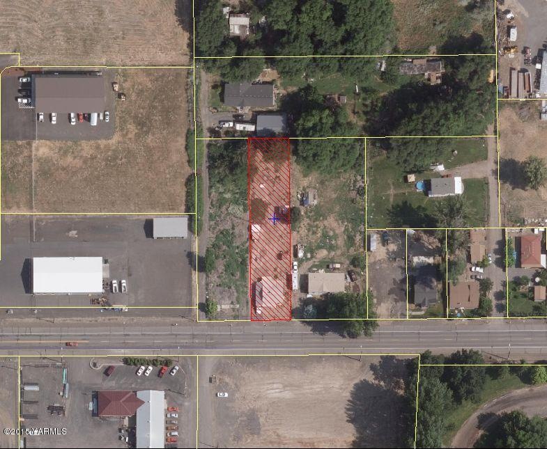
1017 W Lower Ahtanum Rd Union Gap, WA 98903
Estimated Value: $56,775 - $213,000
Highlights
- 0.38 Acre Lot
- Level Lot
- Storage Shed
- Partially Fenced Property
About This Lot
As of March 2016.38 acres zoned light industrial as per City of Union Gap.
Property Details
Property Type
- Land
Lot Details
- 0.38 Acre Lot
- Lot Dimensions are 270 x 61
- Partially Fenced Property
- Level Lot
- Open Lot
- Property is zoned M1 - Light Indus
Outdoor Features
- Storage Shed
Utilities
- Well
- Septic Design Installed
- Phone Available
Listing and Financial Details
- Assessor Parcel Number 181201-23029
Ownership History
Purchase Details
Home Financials for this Owner
Home Financials are based on the most recent Mortgage that was taken out on this home.Home Values in the Area
Average Home Value in this Area
Purchase History
| Date | Buyer | Sale Price | Title Company |
|---|---|---|---|
| Alvarez Miguel | $37,229 | Pacific Alliance Title Co | |
| Alvarez Miguel | $32,000 | Fidelity Title Co |
Mortgage History
| Date | Status | Borrower | Loan Amount |
|---|---|---|---|
| Closed | Alvarez Miguel | $0 |
Property History
| Date | Event | Price | List to Sale | Price per Sq Ft |
|---|---|---|---|---|
| 03/28/2016 03/28/16 | Sold | $32,000 | -- | -- |
| 03/15/2016 03/15/16 | Pending | -- | -- | -- |
Tax History Compared to Growth
Tax History
| Year | Tax Paid | Tax Assessment Tax Assessment Total Assessment is a certain percentage of the fair market value that is determined by local assessors to be the total taxable value of land and additions on the property. | Land | Improvement |
|---|---|---|---|---|
| 2025 | $371 | $45,500 | $45,500 | -- |
| 2023 | $396 | $22,800 | $22,800 | $0 |
| 2022 | $237 | $22,800 | $22,800 | $0 |
| 2021 | $249 | $22,800 | $22,800 | $0 |
| 2019 | $232 | $22,800 | $22,800 | $0 |
| 2018 | $259 | $22,800 | $22,800 | $0 |
| 2017 | $991 | $57,100 | $22,800 | $34,300 |
| 2016 | $748 | $62,600 | $22,800 | $39,800 |
| 2015 | $748 | $60,300 | $22,800 | $37,500 |
| 2014 | $748 | $60,900 | $22,800 | $38,100 |
| 2013 | $748 | $60,900 | $22,800 | $38,100 |
Map
Source: MLS Of Yakima Association Of REALTORS®
MLS Number: 15-2361
APN: 181201-23029
Disclaimer: Certain information contained herein is derived from information provided by parties other than Homes.com. All information provided is deemed reliable, but is not guaranteed to be accurate and should be independently verified.
![]() IDX information is provided exclusively for personal, non-commercial use, and may not be used for any purpose other than to identify prospective properties consumers may be interested in purchasing. Information is deemed reliable but not guaranteed.
IDX information is provided exclusively for personal, non-commercial use, and may not be used for any purpose other than to identify prospective properties consumers may be interested in purchasing. Information is deemed reliable but not guaranteed.
- 2608 S 16th Ave
- 2802 S 5th Ave Unit 30
- 2802 S 5th Ave Unit 17
- 2802 S 5th Ave Unit 29
- 2802 S 5th Ave Unit 63
- 2121 S 6th Ave
- 6102 Crown Crest Ave
- 2230 Landon Ave
- 2214&2216 Landon Ave
- 1502 W Washington Ave Unit Lot 7
- 1502 W Washington Ave Unit Lot 8
- 1502 W Washington Ave Unit Lot 9
- 1502 W Washington Ave Unit Lot 5
- 1502 W Washington Ave Unit Lot 1
- 1502 W Washington Ave Unit Lot 6
- 1502 W Washington Ave Unit Lot 3
- 1502 W Washington Ave Unit Lot 4
- 1502 W Washington Ave Unit Lot 2
- 1201 W Washington Ave Unit 36
- 1201 W Washington Ave Unit 15
- 1017 Ahtanum Rd
- 1019 Ahtanum Rd
- 1019 Ahtanum Rd
- 1009 Ahtanum Rd
- 1013 Ahtanum Rd Unit LWR
- 2507 Pleasant Ave
- 1015 Ahtanum Rd
- 1011 Ahtanum Rd
- 1240 Ahtanum Rd
- 1007 Ahtanum Rd Unit R
- 2501 S Pleasant Ave
- 2526 S 12th Ave
- 2500 S 11th Ave
- 2506 S 10th Ave
- 2511 S 10th Ave
- 2507 S 10th Ave
- 2505 S 10th Ave
- 2500 S 12th Ave
- 2605 S 14th Ave
- 1201 Ahtanum Rd