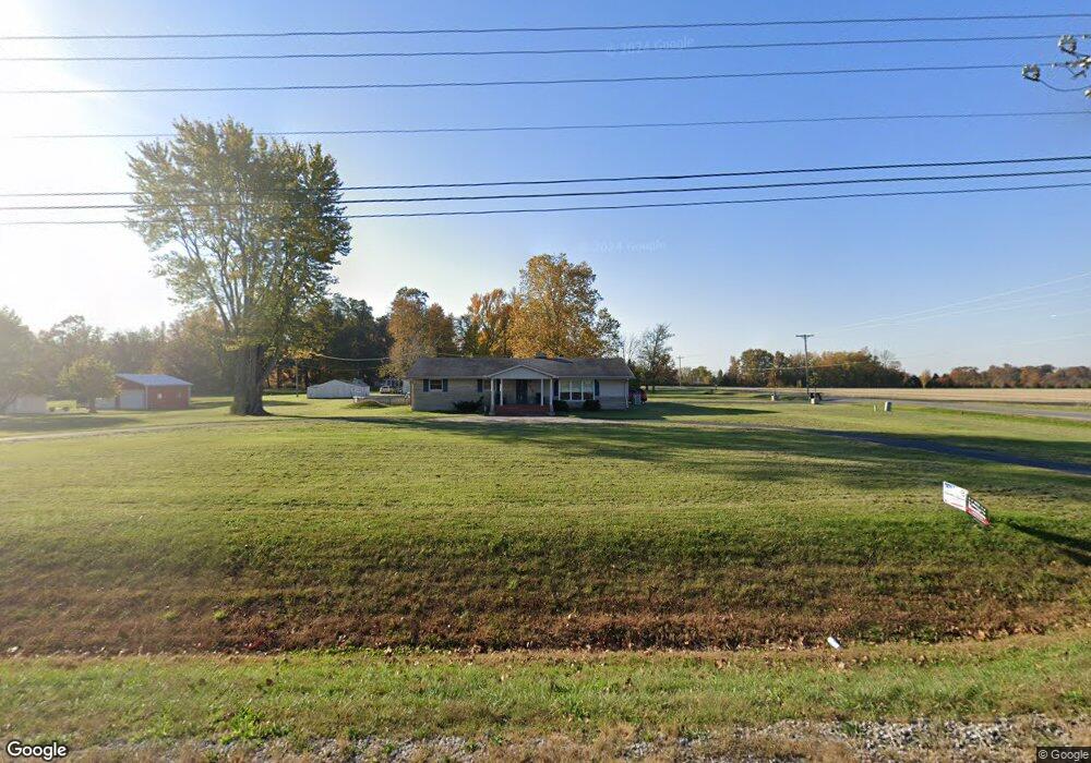
1018 E State Road 256 Austin, IN 47102
Estimated Value: $225,931 - $272,000
3
Beds
2
Baths
2,220
Sq Ft
$110/Sq Ft
Est. Value
About This Home
This home is located at 1018 E State Road 256, Austin, IN 47102 and is currently estimated at $244,983, approximately $110 per square foot. 1018 E State Road 256 is a home located in Scott County with nearby schools including Austin Elementary School, Austin Middle School, and Austin High School.
Ownership History
Date
Name
Owned For
Owner Type
Purchase Details
Closed on
May 26, 2011
Sold by
Shields Joe W and Shields Mary Jane
Bought by
Hutton Jimmy
Current Estimated Value
Home Financials for this Owner
Home Financials are based on the most recent Mortgage that was taken out on this home.
Original Mortgage
$150,000
Outstanding Balance
$104,276
Interest Rate
4.81%
Mortgage Type
VA
Estimated Equity
$140,707
Create a Home Valuation Report for This Property
The Home Valuation Report is an in-depth analysis detailing your home's value as well as a comparison with similar homes in the area
Purchase History
| Date | Buyer | Sale Price | Title Company |
|---|---|---|---|
| Hutton Jimmy | -- | Kemp Title Agency Llc |
Source: Public Records
Mortgage History
| Date | Status | Borrower | Loan Amount |
|---|---|---|---|
| Open | Hutton Jimmy | $150,000 |
Source: Public Records
Tax History
| Year | Tax Paid | Tax Assessment Tax Assessment Total Assessment is a certain percentage of the fair market value that is determined by local assessors to be the total taxable value of land and additions on the property. | Land | Improvement |
|---|---|---|---|---|
| 2024 | $2,684 | $131,800 | $16,000 | $115,800 |
| 2023 | $2,728 | $129,500 | $16,000 | $113,500 |
| 2022 | $2,392 | $131,500 | $16,000 | $115,500 |
| 2021 | $2,234 | $121,600 | $16,000 | $105,600 |
| 2020 | $2,555 | $129,200 | $16,000 | $113,200 |
| 2019 | $2,425 | $124,200 | $16,000 | $108,200 |
| 2018 | $2,165 | $113,900 | $13,000 | $100,900 |
| 2017 | $2,070 | $114,100 | $13,000 | $101,100 |
| 2016 | $418 | $113,000 | $13,000 | $100,000 |
| 2014 | $421 | $112,800 | $13,000 | $99,800 |
| 2013 | $421 | $117,500 | $13,000 | $104,500 |
Source: Public Records
Map
Nearby Homes
- 2481 N Slab Rd
- 4604 N Bogardus Rd
- 329 E Cutshall Rd
- 92 Stonybrook Dr
- 314 Audrey Ln
- 334 Audrey Ln
- 344 Audrey Ln
- 304 Audrey Ln
- 324 Audrey Ln
- 354 Audrey Ln
- 5449 N Terry Rd
- 244 Audrey Ln
- 274 Audrey Ln
- 3183 New Frankfort Rd
- 284 Audrey Ln
- 294 Audrey Ln
- Glacier Plan at Meadowbrook
- Yellowstone Plan at Meadowbrook
- Everglades Plan at Meadowbrook
- 815 Linden Dr
- 1018 W Kent Street 256
- 3428 N Slab Rd
- 1051 E State Road 256
- 3552 N Bogardus Rd
- 1051 Indiana 256
- 3396 N Slab Rd
- 1114 E State Road 256
- 3354 N Slab Rd
- 1178 E State Road 256
- 3296 N Slab Rd
- 3670 N Bogardus Rd
- 3276 N Slab Rd
- 807 E State Road 256
- 0 Cameron Dr
- 3249 N Slab Rd
- 1113 Cameron Dr
- 1151 Cameron Dr
- 3171 N Slab Rd
- 3144 N Slab Rd
- 3127 N Slab Rd
Your Personal Tour Guide
Ask me questions while you tour the home.