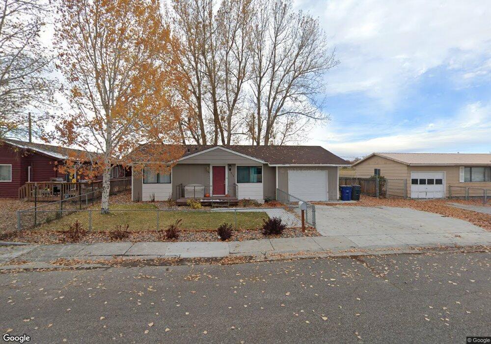
1018 Flag Dr Riverton, WY 82501
Estimated Value: $100,000 - $198,932
3
Beds
1
Bath
944
Sq Ft
$180/Sq Ft
Est. Value
About This Home
This home is located at 1018 Flag Dr, Riverton, WY 82501 and is currently estimated at $170,233, approximately $180 per square foot. 1018 Flag Dr is a home located in Fremont County with nearby schools including Riverton High School and Trinity Lutheran School.
Ownership History
Date
Name
Owned For
Owner Type
Purchase Details
Closed on
Oct 21, 2016
Sold by
Brown King M
Bought by
Cassity Jesse and Adams Stormi
Current Estimated Value
Home Financials for this Owner
Home Financials are based on the most recent Mortgage that was taken out on this home.
Original Mortgage
$123,232
Outstanding Balance
$98,919
Interest Rate
3.5%
Mortgage Type
New Conventional
Estimated Equity
$71,314
Purchase Details
Closed on
Jul 31, 2007
Sold by
Hill Edwin J
Bought by
Brown Ii King M
Home Financials for this Owner
Home Financials are based on the most recent Mortgage that was taken out on this home.
Original Mortgage
$118,000
Interest Rate
6.64%
Mortgage Type
New Conventional
Create a Home Valuation Report for This Property
The Home Valuation Report is an in-depth analysis detailing your home's value as well as a comparison with similar homes in the area
Home Values in the Area
Average Home Value in this Area
Purchase History
| Date | Buyer | Sale Price | Title Company |
|---|---|---|---|
| Cassity Jesse | -- | County Title Inc Folder | |
| Brown Ii King M | -- | None Available |
Source: Public Records
Mortgage History
| Date | Status | Borrower | Loan Amount |
|---|---|---|---|
| Open | Cassity Jesse | $123,232 | |
| Previous Owner | Brown Ii King M | $118,000 |
Source: Public Records
Tax History Compared to Growth
Tax History
| Year | Tax Paid | Tax Assessment Tax Assessment Total Assessment is a certain percentage of the fair market value that is determined by local assessors to be the total taxable value of land and additions on the property. | Land | Improvement |
|---|---|---|---|---|
| 2025 | $1,079 | $10,710 | $1,078 | $9,632 |
| 2024 | $1,079 | $13,787 | $1,438 | $12,349 |
| 2023 | $895 | $11,214 | $1,438 | $9,776 |
| 2022 | $774 | $9,899 | $1,438 | $8,461 |
| 2021 | $784 | $9,750 | $1,438 | $8,312 |
| 2020 | $761 | $9,458 | $1,438 | $8,020 |
| 2019 | $722 | $9,190 | $1,438 | $7,752 |
| 2018 | $807 | $10,290 | $1,438 | $8,852 |
| 2017 | $689 | $8,762 | $1,438 | $7,324 |
| 2016 | $674 | $8,662 | $1,438 | $7,224 |
| 2015 | $674 | $8,473 | $1,438 | $7,035 |
| 2014 | $545 | $6,897 | $1,438 | $5,459 |
Source: Public Records
Map
Nearby Homes
- 409 Northpointe Dr
- Lot 2 Parkview
- 755 N 2nd St W
- 922 Sierra Dr
- 915 Sierra Dr
- 1104 Big Horn Dr
- 1015 Moose Dr
- 220 N 5th St W
- 621 W Fremont Ave
- 210 N 5th St W
- 216 Valley Cir
- 203 Appaloosa Dr
- 524 N 2nd St E
- 832 Rainbow Dr
- 312 E Sunset Dr
- 1113 Fairview Dr
- 1221 Fairview Dr
- 518 N 3rd St E
- 1307 N Broadway Ave
- 1303 N Broadway Ave
- 1018 Flag Dr Unit Independence Drive
- 904 Independence Dr
- 1022 Flag Dr
- 1019 Flag Dr
- 830 Independence Dr
- 829 Liberty Dr
- 826 Liberty Dr
- 826 Liberty Dr Unit Flag
- 830 Liberty Dr
- 822 Independence Dr
- 823 Liberty Dr
- 818 Independence Dr
- 818 Independence Dr Unit N 8th W
- 822 Liberty Dr
- 814 Independence Dr
- 814 Independence Dr Unit N 8th St W
- 818 Liberty Dr
- 814 Liberty Dr
- 811 Independence Dr
- 807 Independence Dr