Estimated Value: $434,489
Studio
--
Bath
1,900
Sq Ft
$229/Sq Ft
Est. Value
About This Home
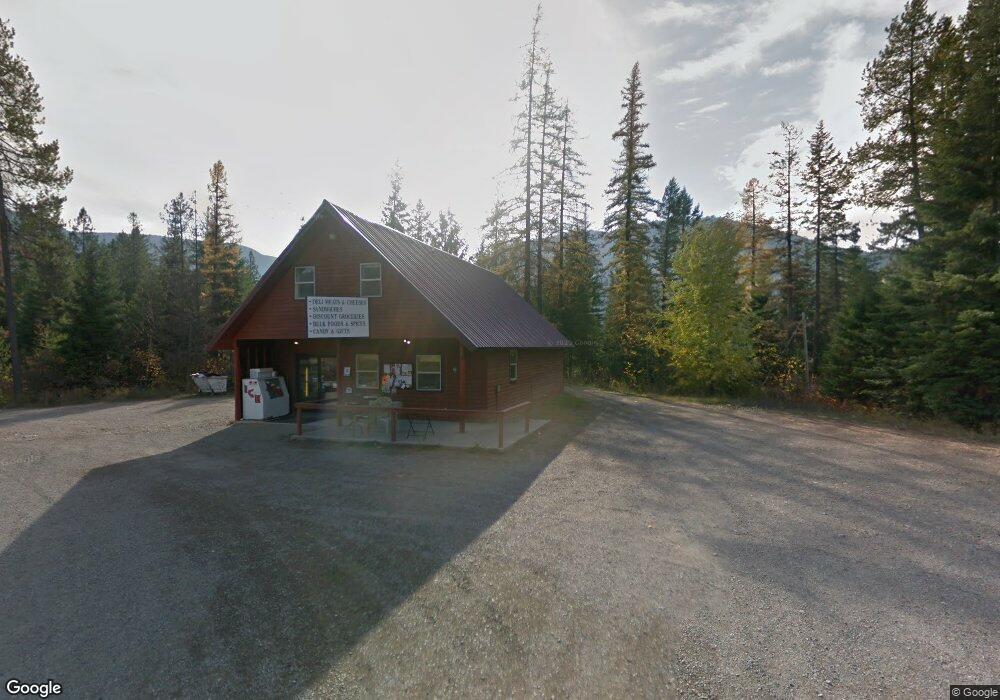
This home is located at 1018 Mt Highway 200, Noxon, MT 59853 and is currently priced at $434,489, approximately $228 per square foot. 1018 Mt Highway 200 is a home located in Sanders County with nearby schools including Noxon Elementary School, Noxon Junior High School, and Noxon High School.
Ownership History
Date
Name
Owned For
Owner Type
Purchase Details
Closed on
Mar 3, 2026
Sold by
Daniel Waddington and Nona Waddington
Bought by
S & Y Ventures Llc
Current Estimated Value
Home Financials for this Owner
Home Financials are based on the most recent Mortgage that was taken out on this home.
Original Mortgage
$255,000
Outstanding Balance
$255,000
Interest Rate
6.09%
Mortgage Type
New Conventional
Purchase Details
Closed on
Aug 5, 2022
Sold by
Van Vleet
Bought by
Waddington Daniel and Waddington Nona
Home Financials for this Owner
Home Financials are based on the most recent Mortgage that was taken out on this home.
Original Mortgage
$402,264
Interest Rate
5.81%
Mortgage Type
New Conventional
Create a Home Valuation Report for This Property
The Home Valuation Report is an in-depth analysis detailing your home's value as well as a comparison with similar homes in the area
Purchase History
| Date | Buyer | Sale Price | Title Company |
|---|---|---|---|
| S & Y Ventures Llc | -- | Flying S Title And Escrow Of M | |
| Waddington Daniel | -- | None Listed On Document |
Source: Public Records
Mortgage History
| Date | Status | Borrower | Loan Amount |
|---|---|---|---|
| Open | S & Y Ventures Llc | $255,000 | |
| Previous Owner | Waddington Daniel | $402,264 |
Source: Public Records
Tax History
| Year | Tax Paid | Tax Assessment Tax Assessment Total Assessment is a certain percentage of the fair market value that is determined by local assessors to be the total taxable value of land and additions on the property. | Land | Improvement |
|---|---|---|---|---|
| 2025 | $3,793 | $396,110 | $0 | $0 |
| 2024 | $4,360 | $370,300 | $0 | $0 |
| 2023 | $4,137 | $370,300 | $0 | $0 |
| 2022 | $3,041 | $176,580 | $0 | $0 |
| 2021 | $1,494 | $176,580 | $0 | $0 |
| 2020 | $2,545 | $165,220 | $0 | $0 |
| 2019 | $2,544 | $165,220 | $0 | $0 |
| 2018 | $2,357 | $156,620 | $0 | $0 |
| 2017 | $1,265 | $156,620 | $0 | $0 |
| 2016 | $1,020 | $106,900 | $0 | $0 |
| 2015 | $723 | $106,900 | $0 | $0 |
| 2014 | $901 | $102,152 | $0 | $0 |
Source: Public Records
Map
Nearby Homes
- 2 Rainbow Ct
- 1127 Mt Highway 200
- 7 Conifer Ln
- 1234 Montana 200
- 300 Old Bull River Rd
- Nhn Creek View Ln
- 2 Trails End Dr
- 710 Noxon Ave
- 608 Noxon Ave
- 203 3rd St
- 0 Rd
- Nhn Pilgrim Creek Rd
- 151 Government Mountain Rd
- 230 Klakken Rd
- 115, 131 and 133 Klakken Rd
- 116 Klakken Rd
- 133 Klakken Rd
- 5 Buckhill Dr
- 8 Dead Horse Ln
- 49 Government Mountain Rd
- 1018 Montana 200
- 1016 Mt Highway 200
- 1021 Mt Highway 200
- 1021 Montana 200
- 1025 Mt Highway 200
- 10 Cabinet Lake Dr
- 1002 Mt Highway 200
- 68 Cabinet Lake Dr Noxon
- 68 Cabinet Lake Dr
- 68 Cabinet Lake Dr
- 52 Cabinet Lake Dr
- 7 Blue Jay Ln
- 40 Cabinet Lake Dr
- 992 Mt Highway 200
- Lot 1 Rainbow Loop
- Lot 18 Rainbow Loop
- Lot 18 Bull River Bay Estates
- 5 Rainbow Loop
- Lot 013 Cabinet Lake Addition
- 20 Rainbow Loop
Your Personal Tour Guide
Ask me questions while you tour the home.