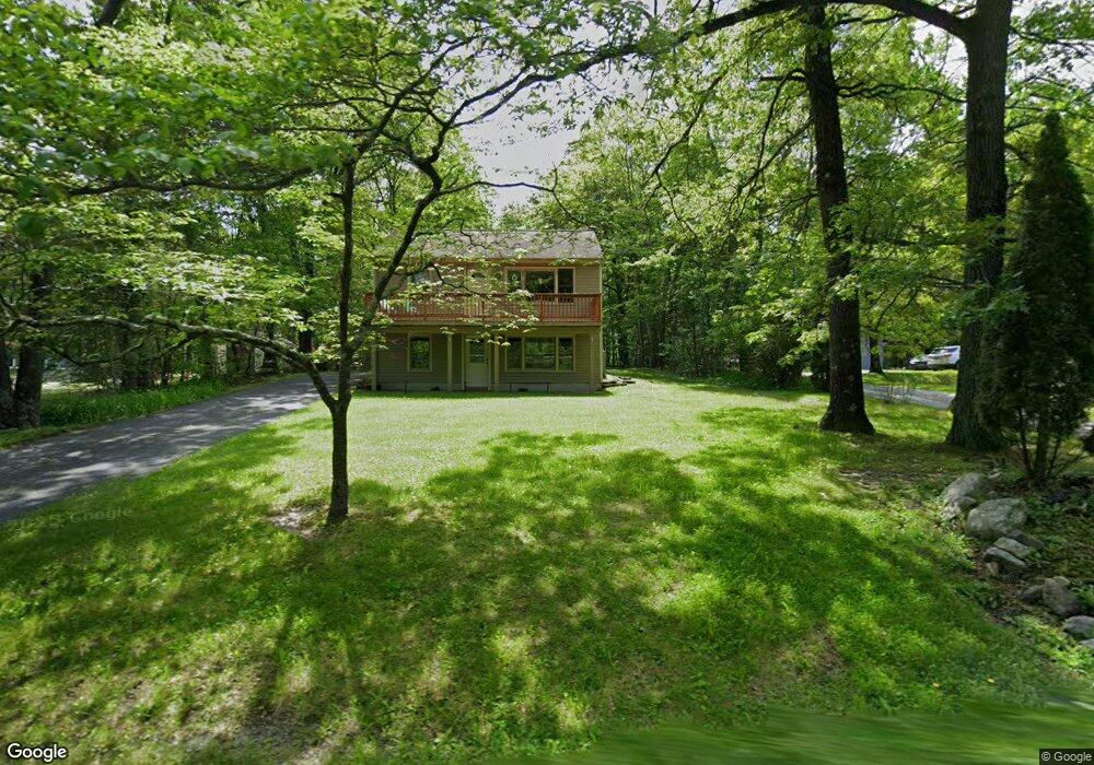
1018 Owassa Rd Newton, NJ 07860
Estimated Value: $300,000 - $382,000
--
Bed
--
Bath
1,120
Sq Ft
$307/Sq Ft
Est. Value
About This Home
This home is located at 1018 Owassa Rd, Newton, NJ 07860 and is currently estimated at $343,380, approximately $306 per square foot. 1018 Owassa Rd is a home located in Sussex County with nearby schools including Stillwater Township School and Kittatinny Regional High School.
Ownership History
Date
Name
Owned For
Owner Type
Purchase Details
Closed on
Nov 8, 2010
Sold by
Secretary Of Housing & Urban Development
Bought by
Eaton Leann A
Current Estimated Value
Home Financials for this Owner
Home Financials are based on the most recent Mortgage that was taken out on this home.
Original Mortgage
$107,536
Outstanding Balance
$75,259
Interest Rate
5.5%
Mortgage Type
FHA
Estimated Equity
$268,121
Purchase Details
Closed on
Apr 22, 2009
Sold by
Melhus Frank A and Melhus Heather M
Bought by
Secretary Of Housing & Urban Development
Create a Home Valuation Report for This Property
The Home Valuation Report is an in-depth analysis detailing your home's value as well as a comparison with similar homes in the area
Home Values in the Area
Average Home Value in this Area
Purchase History
| Date | Buyer | Sale Price | Title Company |
|---|---|---|---|
| Eaton Leann A | $75,000 | Collegiate Title Corporation | |
| Secretary Of Housing & Urban Development | $110,000 | None Available |
Source: Public Records
Mortgage History
| Date | Status | Borrower | Loan Amount |
|---|---|---|---|
| Open | Eaton Leann A | $107,536 |
Source: Public Records
Tax History Compared to Growth
Tax History
| Year | Tax Paid | Tax Assessment Tax Assessment Total Assessment is a certain percentage of the fair market value that is determined by local assessors to be the total taxable value of land and additions on the property. | Land | Improvement |
|---|---|---|---|---|
| 2025 | $6,440 | $177,500 | $44,900 | $132,600 |
| 2024 | $6,234 | $177,500 | $44,900 | $132,600 |
| 2023 | $6,234 | $177,500 | $44,900 | $132,600 |
| 2022 | $6,042 | $177,500 | $44,900 | $132,600 |
| 2021 | $5,909 | $177,500 | $44,900 | $132,600 |
| 2020 | $5,696 | $177,500 | $44,900 | $132,600 |
| 2019 | $5,467 | $177,500 | $44,900 | $132,600 |
| 2018 | $5,481 | $177,500 | $44,900 | $132,600 |
| 2017 | $5,394 | $177,500 | $44,900 | $132,600 |
| 2016 | $5,243 | $177,500 | $44,900 | $132,600 |
| 2015 | $5,211 | $177,500 | $44,900 | $132,600 |
| 2014 | $5,176 | $177,500 | $44,900 | $132,600 |
Source: Public Records
Map
Nearby Homes
- 00 Plymouth Lake Dr
- 947 Plymouth Lake Dr
- 0 Mount Benevolence Rd
- 921 Tulip Trail
- 903 Twin Oaks Rd
- 903 Aspen Ct
- 908 Willow Dr
- 000 Pepperidge Dr
- 31 Kent Rd
- 8 Possaghi Rd
- 17 Eastbrook Ln
- 68 W Shore Dr
- 121 W Shore Dr
- 21 Lake Rd
- 90 Kemah Mecca Lake Rd
- 17 17 West Owassa Tnpk
- 1071 County Road 521
- 1055-1057 Rt521
- 1049 County Road 521
- 25 County Road 521
- 1016 Owassa Rd
- 1020 Owassa Rd
- 1015 Owassa Rd
- 1022 Owassa Rd
- 1014 Owassa Rd
- 1013 Owassa Rd
- 1024 Owassa Rd
- 1011 Owassa Rd
- 903 Owassa Rd
- 1009 Owassa Rd
- 1007 Owassa Rd
- 1025 Owassa Rd
- 1002 Owassa Rd
- 1027 Owassa Rd
- 1000 Owassa Rd
- 1004 Owassa Rd
- 997 Owassa Rd
- 998 Owassa Rd
- 996 Owassa Rd
- 924 Plymouth Lake Dr E