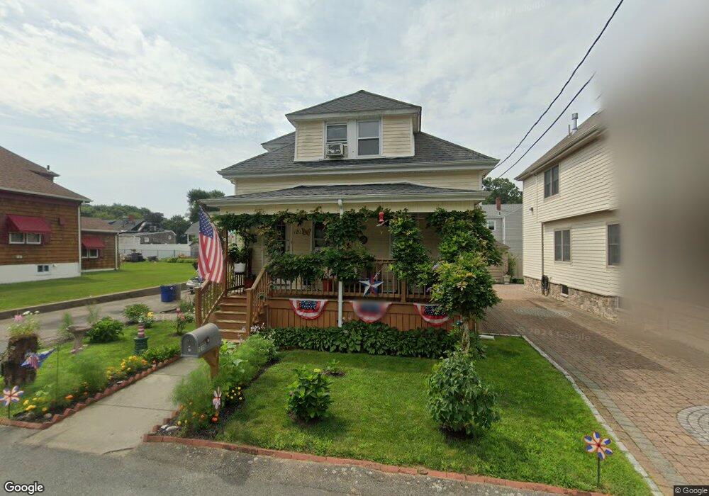
1018 Sheffield St New Bedford, MA 02745
Acushnet-Pine Hill NeighborhoodEstimated Value: $376,000 - $418,000
2
Beds
1
Bath
1,366
Sq Ft
$293/Sq Ft
Est. Value
About This Home
This home is located at 1018 Sheffield St, New Bedford, MA 02745 and is currently estimated at $400,457, approximately $293 per square foot. 1018 Sheffield St is a home located in Bristol County with nearby schools including Casimir Pulaski Elementary School, Normandin Middle School, and New Bedford High School.
Ownership History
Date
Name
Owned For
Owner Type
Purchase Details
Closed on
Dec 1, 2023
Sold by
Fletcher Patricia D
Bought by
Patricia D Fletcher Lt and Fletcher
Current Estimated Value
Purchase Details
Closed on
Sep 30, 2011
Sold by
Peters William F
Bought by
Fletcher Patricia D
Create a Home Valuation Report for This Property
The Home Valuation Report is an in-depth analysis detailing your home's value as well as a comparison with similar homes in the area
Home Values in the Area
Average Home Value in this Area
Purchase History
| Date | Buyer | Sale Price | Title Company |
|---|---|---|---|
| Patricia D Fletcher Lt | -- | None Available | |
| Patricia D Fletcher Lt | -- | None Available | |
| Fletcher Patricia D | $100,000 | -- | |
| Fletcher Patricia D | $100,000 | -- |
Source: Public Records
Tax History Compared to Growth
Tax History
| Year | Tax Paid | Tax Assessment Tax Assessment Total Assessment is a certain percentage of the fair market value that is determined by local assessors to be the total taxable value of land and additions on the property. | Land | Improvement |
|---|---|---|---|---|
| 2025 | $3,710 | $328,000 | $108,200 | $219,800 |
| 2024 | $3,509 | $292,400 | $101,400 | $191,000 |
| 2023 | $3,484 | $243,800 | $86,200 | $157,600 |
| 2022 | $3,202 | $213,700 | $86,200 | $127,500 |
| 2021 | $3,202 | $205,400 | $84,500 | $120,900 |
| 2020 | $3,195 | $197,700 | $84,500 | $113,200 |
| 2019 | $3,142 | $190,800 | $84,500 | $106,300 |
| 2018 | $2,967 | $178,400 | $84,500 | $93,900 |
| 2017 | $2,777 | $166,400 | $82,800 | $83,600 |
| 2016 | $2,530 | $153,400 | $76,100 | $77,300 |
| 2015 | $2,303 | $146,400 | $74,400 | $72,000 |
| 2014 | $2,206 | $145,500 | $76,100 | $69,400 |
Source: Public Records
Map
Nearby Homes
- 1269 Bartlett St
- 1045 Forbes St
- ES Acushnet Ave
- 26 Rounseville St
- 700 Pine Hill Dr
- 62 Longview Rd
- 2992 Acushnet Ave
- 868 Phillips Rd
- 2981 Acushnet Ave
- 1350 Phillips Rd
- 13 Fairway Dr
- 1044 Phillips Rd Unit 20
- 1044 Phillips Rd Unit 24
- SS Charbonneau Ln
- 1023 Bowles St
- 5 Fairway Dr
- 1063 Westgate St
- 1251 Church St Unit 10
- 40 Nancy St
- 1261 Church St Unit 70
- 1024 Sheffield St
- 1016 Sheffield St
- 1013 Marlborough St
- 1023 Marlborough St Unit 1025
- 1015 Sheffield St
- 1023 Sheffield St
- 1027 Marlborough St Unit 1029
- 3393 Acushnet Ave
- 1033 Marlborough St Unit 1035
- 1031 Sheffield St
- 3405 Acushnet Ave
- 3365 Acushnet Ave
- 1032 Marlborough St
- 3388 Acushnet Ave Unit 2ND FLOOR
- 3388 Acushnet Ave Unit 1ST FLOOR
- 3388 Acushnet Ave Unit 1
- 3388 Acushnet Ave
- 3388A Acushnet Ave
- 3388 Acushnet Ave Unit 2
- 1032 Sheffield St