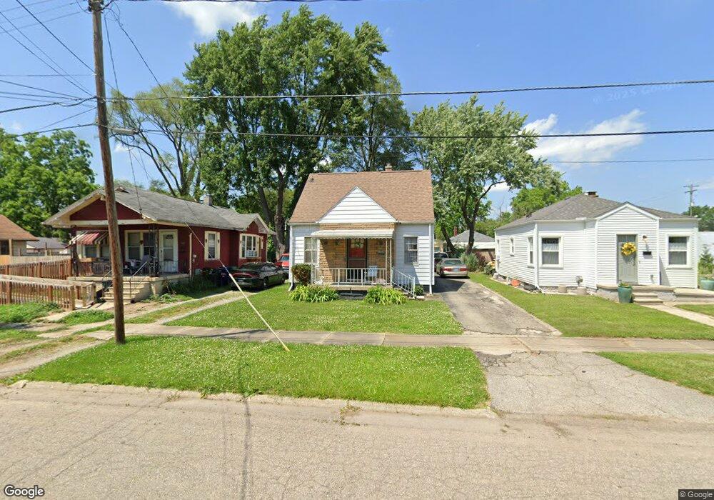
1018 SiMcOe Ave Flint, MI 48507
South Side NeighborhoodEstimated Value: $50,000 - $70,000
2
Beds
1
Bath
1,106
Sq Ft
$53/Sq Ft
Est. Value
About This Home
This home is located at 1018 SiMcOe Ave, Flint, MI 48507 and is currently estimated at $58,667, approximately $53 per square foot. 1018 SiMcOe Ave is a home located in Genesee County with nearby schools including Eisenhower School, Flint Southwestern Classical Academy, and International Academy of Flint (K-12).
Ownership History
Date
Name
Owned For
Owner Type
Purchase Details
Closed on
Apr 12, 2023
Sold by
Cole Greg
Bought by
Blue Rock Properties Llc
Current Estimated Value
Home Financials for this Owner
Home Financials are based on the most recent Mortgage that was taken out on this home.
Original Mortgage
$100,000
Interest Rate
6.6%
Mortgage Type
Construction
Purchase Details
Closed on
Dec 21, 2021
Sold by
James Masse
Bought by
Cole Greg
Purchase Details
Closed on
Apr 29, 2009
Sold by
Spence Roxie Marcell
Bought by
Masse James and Masse Deborah
Purchase Details
Closed on
Mar 5, 2009
Sold by
Spence Roxie Marcell
Bought by
Spence Roxie Marcell
Create a Home Valuation Report for This Property
The Home Valuation Report is an in-depth analysis detailing your home's value as well as a comparison with similar homes in the area
Home Values in the Area
Average Home Value in this Area
Purchase History
| Date | Buyer | Sale Price | Title Company |
|---|---|---|---|
| Blue Rock Properties Llc | -- | Sargents Title | |
| Cole Greg | $20,000 | None Listed On Document | |
| Cole Greg | $20,000 | None Listed On Document | |
| Masse James | -- | None Available | |
| Spence Roxie Marcell | -- | None Available |
Source: Public Records
Mortgage History
| Date | Status | Borrower | Loan Amount |
|---|---|---|---|
| Closed | Blue Rock Properties Llc | $100,000 |
Source: Public Records
Tax History
| Year | Tax Paid | Tax Assessment Tax Assessment Total Assessment is a certain percentage of the fair market value that is determined by local assessors to be the total taxable value of land and additions on the property. | Land | Improvement |
|---|---|---|---|---|
| 2025 | $1,695 | $19,800 | $0 | $0 |
| 2024 | $1,557 | $20,000 | $0 | $0 |
| 2023 | $1,250 | $16,700 | $0 | $0 |
| 2022 | $0 | $14,300 | $0 | $0 |
| 2021 | $1,104 | $13,600 | $0 | $0 |
| 2020 | $1,015 | $11,400 | $0 | $0 |
| 2019 | $998 | $11,300 | $0 | $0 |
| 2018 | $1,137 | $13,300 | $0 | $0 |
| 2017 | $1,106 | $0 | $0 | $0 |
| 2016 | $1,098 | $0 | $0 | $0 |
| 2015 | -- | $0 | $0 | $0 |
| 2014 | -- | $0 | $0 | $0 |
| 2012 | -- | $17,200 | $0 | $0 |
Source: Public Records
Map
Nearby Homes
- 930 Bloor Ave
- 909 Barrie Ave
- 855 Victoria Ave
- 839 SiMcOe Ave
- 839 Barrie Ave
- 834 Remington Ave
- 825 Vermilya Ave
- 805 Vermilya Ave
- 812 Remington Ave
- 741 Barrie Ave
- 1413 Lincoln Ave
- 1130 W Atherton Rd
- 1225 Waldman Ave
- 2021 Brooks St
- 1028 Campbell St
- 1413 Waldman Ave
- 3805 Brunswick Ave
- 3902 Brunswick Ave
- 1410 Berrywood Ln
- 822 Campbell St
- 1014 SiMcOe Ave
- 1022 SiMcOe Ave
- 1019 Barrie Ave
- 1011 Barrie Ave
- 1030 SiMcOe Ave
- 1023 Barrie Ave
- 1015 Barrie Ave
- 2902 Fenton Rd
- 1034 SiMcOe Ave
- 1035 Barrie Ave
- 1017 SiMcOe Ave
- 1013 SiMcOe Ave
- 1021 SiMcOe Ave
- 1025 SiMcOe Ave
- 1031 Barrie Ave
- 1038 SiMcOe Ave
- 1029 SiMcOe Ave
- 1102 SiMcOe Ave
- 1016 Barrie Ave
- 1010 Barrie Ave
Your Personal Tour Guide
Ask me questions while you tour the home.