Estimated Value: $134,000 - $155,000
2
Beds
1
Bath
768
Sq Ft
$192/Sq Ft
Est. Value
About This Home
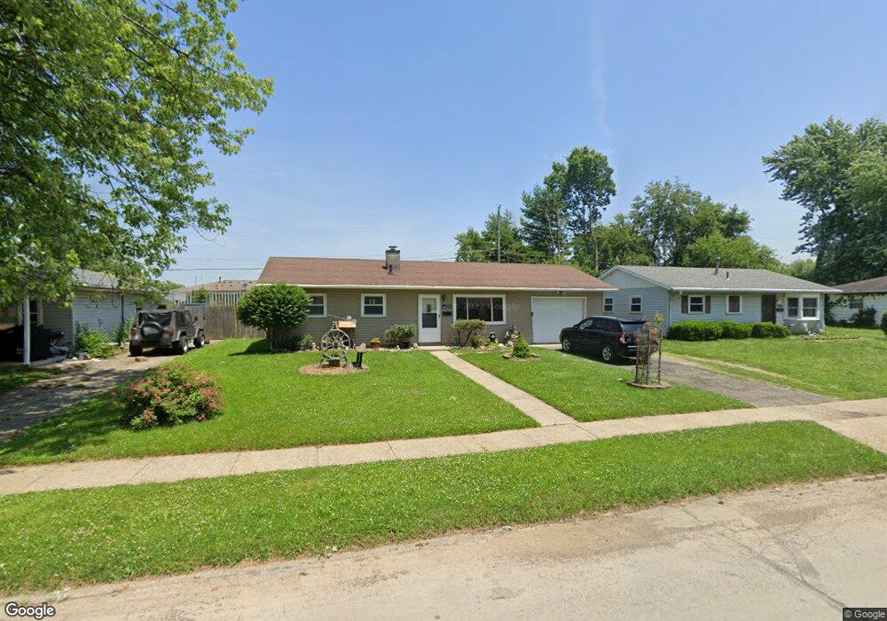
This home is located at 1018 Stewart Ave, Xenia, OH 45385 and is currently estimated at $147,356, approximately $191 per square foot. 1018 Stewart Ave is a home located in Greene County with nearby schools including Xenia High School, Summit Academy Community School for Alternative Learners - Xenia, and Legacy Christian Academy.
Ownership History
Date
Name
Owned For
Owner Type
Purchase Details
Closed on
Jun 1, 2007
Sold by
Fairchild Christina
Bought by
Natt David
Current Estimated Value
Purchase Details
Closed on
Jun 13, 2006
Sold by
Fairchild Christina
Bought by
Natt David A
Purchase Details
Closed on
Aug 30, 2002
Sold by
Baxter Sharon K
Bought by
Natt David A and Fairchild Christina
Home Financials for this Owner
Home Financials are based on the most recent Mortgage that was taken out on this home.
Original Mortgage
$72,659
Interest Rate
6.34%
Mortgage Type
FHA
Create a Home Valuation Report for This Property
The Home Valuation Report is an in-depth analysis detailing your home's value as well as a comparison with similar homes in the area
Home Values in the Area
Average Home Value in this Area
Purchase History
| Date | Buyer | Sale Price | Title Company |
|---|---|---|---|
| Natt David | -- | None Available | |
| Natt David A | -- | None Available | |
| Natt David A | $74,000 | -- |
Source: Public Records
Mortgage History
| Date | Status | Borrower | Loan Amount |
|---|---|---|---|
| Previous Owner | Natt David A | $72,659 |
Source: Public Records
Tax History Compared to Growth
Tax History
| Year | Tax Paid | Tax Assessment Tax Assessment Total Assessment is a certain percentage of the fair market value that is determined by local assessors to be the total taxable value of land and additions on the property. | Land | Improvement |
|---|---|---|---|---|
| 2024 | $1,474 | $34,440 | $8,610 | $25,830 |
| 2023 | $1,474 | $34,440 | $8,610 | $25,830 |
| 2022 | $1,204 | $24,000 | $6,150 | $17,850 |
| 2021 | $1,220 | $24,000 | $6,150 | $17,850 |
| 2020 | $1,169 | $24,000 | $6,150 | $17,850 |
| 2019 | $1,223 | $23,630 | $4,410 | $19,220 |
| 2018 | $1,228 | $23,630 | $4,410 | $19,220 |
| 2017 | $1,192 | $23,630 | $4,410 | $19,220 |
| 2016 | $1,187 | $22,420 | $4,410 | $18,010 |
| 2015 | $1,190 | $22,420 | $4,410 | $18,010 |
| 2014 | $1,140 | $22,420 | $4,410 | $18,010 |
Source: Public Records
Map
Nearby Homes
- 1030 Stewart Ave
- 1006 Stewart Ave
- 991 Parnell Dr
- 1044 Stewart Ave
- 992 Stewart Ave
- 1003 Parnell Dr
- 981 Parnell Dr
- 1023 Stewart Ave
- 1011 Stewart Ave
- 969 Parnell Dr
- 1035 Stewart Ave
- 1056 Stewart Ave
- 980 Stewart Ave
- 999 Stewart Ave
- 1047 Stewart Ave
- 957 Parnell Dr
- 987 Stewart Ave
- 1025 Parnell Dr
- 968 Stewart Ave
- 1061 Stewart Ave