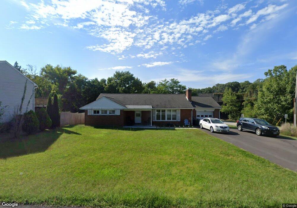
10182 High Ridge Rd Laurel, MD 20723
North Laurel NeighborhoodEstimated Value: $411,000 - $547,000
Studio
3
Baths
1,488
Sq Ft
$325/Sq Ft
Est. Value
About This Home
This home is located at 10182 High Ridge Rd, Laurel, MD 20723 and is currently estimated at $484,288, approximately $325 per square foot. 10182 High Ridge Rd is a home located in Howard County with nearby schools including Gorman Crossing Elementary School, Hammond Middle School, and Reservoir High School.
Ownership History
Date
Name
Owned For
Owner Type
Purchase Details
Closed on
Aug 3, 1999
Sold by
Kirkham Marshall M
Bought by
Kemp Paul D
Current Estimated Value
Purchase Details
Closed on
Feb 27, 1998
Sold by
Sweetland Ronald D
Bought by
Kirkham Marshall M and Kirkham Betty S
Purchase Details
Closed on
Oct 26, 1981
Sold by
Simmons Sidney A and Simmons Wf
Bought by
Sweetland Ronald D
Create a Home Valuation Report for This Property
The Home Valuation Report is an in-depth analysis detailing your home's value as well as a comparison with similar homes in the area
Home Values in the Area
Average Home Value in this Area
Purchase History
We collect this data history from publicly available records. To have your information removed, we recommend requesting removal directly through your county’s website.
| Date | Buyer | Sale Price | Title Company |
|---|---|---|---|
| Kemp Paul D | $150,000 | -- | |
| Kirkham Marshall M | $135,000 | -- | |
| Sweetland Ronald D | $78,000 | -- |
Source: Public Records
Mortgage History
We collect this data history from publicly available records. To have your information removed, we recommend requesting removal directly through your county’s website.
| Date | Status | Borrower | Loan Amount |
|---|---|---|---|
| Closed | Kirkham Marshall M | -- |
Source: Public Records
Tax History
| Year | Tax Paid | Tax Assessment Tax Assessment Total Assessment is a certain percentage of the fair market value that is determined by local assessors to be the total taxable value of land and additions on the property. | Land | Improvement |
|---|---|---|---|---|
| 2025 | $6,519 | $424,400 | $184,200 | $240,200 |
| 2024 | $6,519 | $412,433 | $0 | $0 |
| 2023 | $6,092 | $400,467 | $0 | $0 |
| 2022 | $5,797 | $388,500 | $189,200 | $199,300 |
| 2021 | $5,427 | $367,467 | $0 | $0 |
| 2020 | $5,319 | $348,833 | $0 | $0 |
| 2019 | $5,072 | $325,400 | $116,800 | $208,600 |
| 2018 | $3,470 | $310,200 | $0 | $0 |
| 2017 | $3,418 | $325,400 | $0 | $0 |
| 2016 | -- | $279,800 | $0 | $0 |
| 2015 | -- | $276,233 | $0 | $0 |
| 2014 | -- | $272,667 | $0 | $0 |
Source: Public Records
Map
Nearby Homes
- 9081 Dumhart Rd
- 9318 Sydney Way
- 8807 Ashberry Ct
- 8816 Doves Fly Way
- 8701 Cresthill Ct
- 9260 Old Scaggsville Rd
- 8702 Cresthill Ct
- 9316 All Saints Rd
- 9308 All Saints Rd
- 9429 Fairview Ave
- 8728 Doves Fly Way
- 9425 Fairview Ave
- 211 Patuxent Rd
- 221 Patuxent Rd
- 15925 Dorset Rd
- 212 11th St
- 7209 Brooklyn Bridge Rd
- 1106 Snowden Place
- 15837 Millbrook Ln
- 7106 Donston Dr
- 10180 High Ridge Rd
- 10178 High Ridge Rd
- 10129 Stansfield Rd
- 10132 Stansfield Rd
- 10181 High Ridge Rd
- 10128 Stansfield Rd
- 10179 High Ridge Rd
- 10125 Stansfield Rd
- 10172 High Ridge Rd
- 10170 High Ridge Rd
- 10124 Stansfield Rd
- 10175 High Ridge Rd
- 10120 Stansfield Rd
- 10122 Stansfield Rd
- 10168 High Ridge Rd
- 10171 High Ridge Rd
- 10121 Stansfield Rd
- 10169 High Ridge Rd
- 10109 Lily Pond Dr
- 10126 Wilnor Way
Your Personal Tour Guide
Ask me questions while you tour the home.