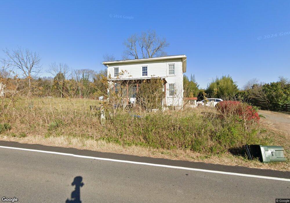
10187 Spotswood Trail Gordonsville, VA 22942
Estimated Value: $266,000 - $355,000
3
Beds
2
Baths
1,872
Sq Ft
$166/Sq Ft
Est. Value
About This Home
This home is located at 10187 Spotswood Trail, Gordonsville, VA 22942 and is currently estimated at $310,745, approximately $165 per square foot. 10187 Spotswood Trail is a home located in Orange County with nearby schools including Gordon Barbour Elementary School, Prospect Heights Middle School, and Orange County High School.
Ownership History
Date
Name
Owned For
Owner Type
Purchase Details
Closed on
Feb 9, 2005
Sold by
Jpmorgan Chase Bank
Bought by
Boyle Daniel Robert
Current Estimated Value
Home Financials for this Owner
Home Financials are based on the most recent Mortgage that was taken out on this home.
Original Mortgage
$23,200
Interest Rate
5.64%
Mortgage Type
Stand Alone Second
Create a Home Valuation Report for This Property
The Home Valuation Report is an in-depth analysis detailing your home's value as well as a comparison with similar homes in the area
Home Values in the Area
Average Home Value in this Area
Purchase History
| Date | Buyer | Sale Price | Title Company |
|---|---|---|---|
| Boyle Daniel Robert | $116,000 | None Available | |
| Jpmorgan Chase Bank | -- | None Available |
Source: Public Records
Mortgage History
| Date | Status | Borrower | Loan Amount |
|---|---|---|---|
| Closed | Boyle Daniel Robert | $23,200 | |
| Open | Jpmorgan Chase Bank | $92,800 | |
| Closed | Boyle Daniel Robert | $92,800 |
Source: Public Records
Tax History Compared to Growth
Tax History
| Year | Tax Paid | Tax Assessment Tax Assessment Total Assessment is a certain percentage of the fair market value that is determined by local assessors to be the total taxable value of land and additions on the property. | Land | Improvement |
|---|---|---|---|---|
| 2024 | $1,317 | $175,600 | $61,700 | $113,900 |
| 2023 | $1,317 | $175,600 | $61,700 | $113,900 |
| 2022 | $1,317 | $175,600 | $61,700 | $113,900 |
| 2021 | $1,264 | $175,600 | $61,700 | $113,900 |
| 2020 | $1,264 | $175,600 | $61,700 | $113,900 |
| 2019 | $1,167 | $145,200 | $61,700 | $83,500 |
| 2018 | $1,167 | $145,200 | $61,700 | $83,500 |
| 2017 | $1,167 | $145,200 | $61,700 | $83,500 |
| 2016 | $1,167 | $145,200 | $61,700 | $83,500 |
| 2015 | $1,092 | $151,600 | $61,700 | $89,900 |
| 2014 | $1,092 | $151,600 | $61,700 | $89,900 |
Source: Public Records
Map
Nearby Homes
- 406 E Baker St
- 306 Paynor Ave
- 19312 Briar Patch Dr
- 10137 Spring Dr
- 10109 Pond Ct
- 312 East St
- 314 East St
- 0 East St Unit VAOR2012394
- 318 Union Ave
- 304 Lucketts Alley
- 14603 Cox Mill Rd
- 10485 Cedar Hill Rd
- 0 Charles St Unit VAOR2008142
- 15 Tall Oaks Ln
- 910 Hanback Rd
- 15 Hanback Rd
- 14 Hanback Rd
- 960 Hanback Rd
- 1026 Hanback Rd
- Lot 1 Hanback Rd
- 10171 Spotswood Trail
- 10201 Spotswood Trail
- 10205 Spotswood Trail
- 18338 Spotswood Trail
- 10240 Spotswood Trail
- 19074 Blue Ridge Turnpike
- 19052 Blue Ridge Turnpike
- 19064 Blue Ridge Turnpike
- 4 Brimfell St
- 1 Cleveland St
- TBD Blue Ridge Turnpike
- 19055 Cameron Rd
- 10047 Spotswood Trail
- 611 N Main St
- 612 N Main St
- 609 N Main St
- 18521 Cameron Rd
- 610 N Main St
- 607 N Main St Unit 33A,33,25
- 607 N Main St