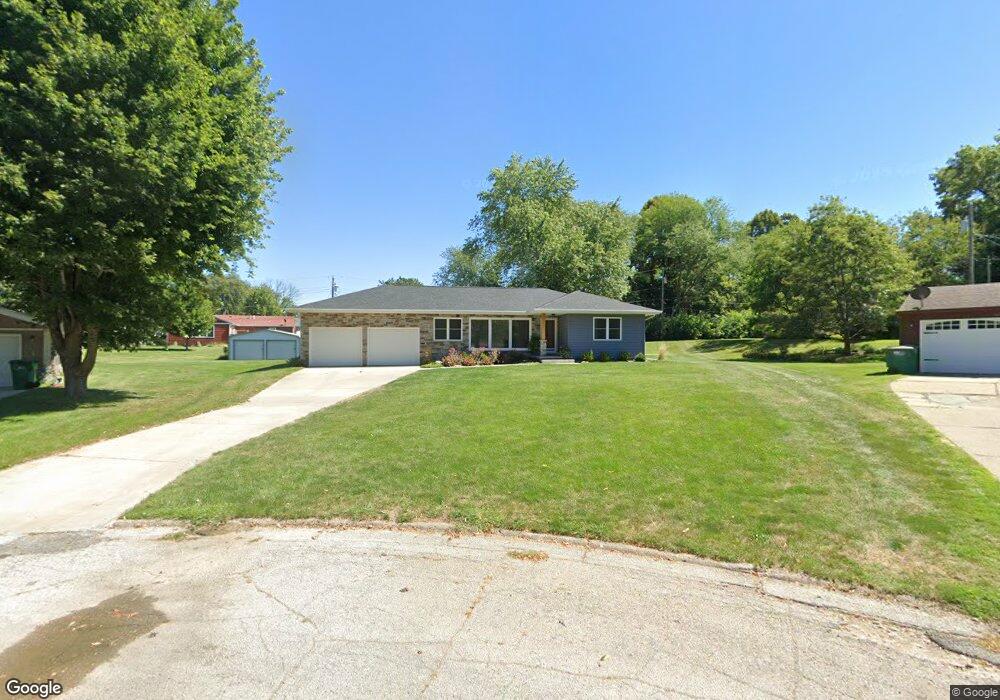
1019 Crest Dr Creston, IA 50801
Estimated Value: $230,000 - $311,000
3
Beds
4
Baths
1,888
Sq Ft
$153/Sq Ft
Est. Value
About This Home
This home is located at 1019 Crest Dr, Creston, IA 50801 and is currently estimated at $288,171, approximately $152 per square foot. 1019 Crest Dr is a home with nearby schools including Creston Early Childhood Center, Creston Elementary School, and Creston Middle School.
Ownership History
Date
Name
Owned For
Owner Type
Purchase Details
Closed on
Aug 5, 2022
Sold by
Pearson Douglas and Pearson Sheryl
Bought by
Douglas And Sheryl Pearson Living Trust and Pearson
Current Estimated Value
Create a Home Valuation Report for This Property
The Home Valuation Report is an in-depth analysis detailing your home's value as well as a comparison with similar homes in the area
Home Values in the Area
Average Home Value in this Area
Purchase History
| Date | Buyer | Sale Price | Title Company |
|---|---|---|---|
| Douglas And Sheryl Pearson Living Trust | -- | None Listed On Document |
Source: Public Records
Tax History
| Year | Tax Paid | Tax Assessment Tax Assessment Total Assessment is a certain percentage of the fair market value that is determined by local assessors to be the total taxable value of land and additions on the property. | Land | Improvement |
|---|---|---|---|---|
| 2025 | $5,428 | $349,380 | $19,820 | $329,560 |
| 2024 | $5,428 | $315,380 | $19,820 | $295,560 |
| 2023 | $4,092 | $210,010 | $25,730 | $184,280 |
| 2022 | $4,054 | $178,410 | $25,730 | $152,680 |
| 2021 | $4,054 | $166,740 | $24,050 | $142,690 |
| 2020 | $3,300 | $161,480 | $21,650 | $139,830 |
| 2019 | $3,372 | $142,000 | $0 | $0 |
| 2018 | $3,214 | $142,000 | $0 | $0 |
| 2017 | $3,214 | $139,210 | $0 | $0 |
| 2016 | $3,134 | $139,210 | $0 | $0 |
| 2015 | $3,134 | $127,710 | $0 | $0 |
| 2014 | $2,936 | $127,710 | $0 | $0 |
Source: Public Records
Map
Nearby Homes
- 1011 Crest Dr
- 1009 Crest Dr
- 3 SW Corner of Townline St & N Su Unit Lots
- 910 N Sycamore St
- 1102 N Division St
- 703 W Devoe St
- 1110 Sunrise Dr
- 814 N Sycamore St
- 1412 Elm Dr
- 820 N Elm St
- 1401 N Elm St
- 601 W Irving St
- 1202 N Walnut St
- 606 N Elm St
- 614 N Maple St
- 1101 N Walnut St
- 609 N Maple St
- 204 E Prairie St
- 507 W Howard St
- 1105 N Birch St
- 1017 Crest Dr
- 1021 Crest Dr
- 1012 N Spruce St
- 1023 Crest Dr
- 1014 N Spruce St
- 1015 Crest Dr
- 1016 N Spruce St
- 1008 N Spruce St
- 1007 Crest Dr
- 1025 Crest Dr
- 1012 Crest Dr
- 1018 N Spruce St
- 1018 Crest Dr
- 1027 Crest Dr
- 1014 Crest Dr
- 1010 1/2 Crest Dr
- 1006 N Spruce St
- 1016 Crest Dr
- 1005 Crest Dr
- 1010 Crest Dr
Your Personal Tour Guide
Ask me questions while you tour the home.