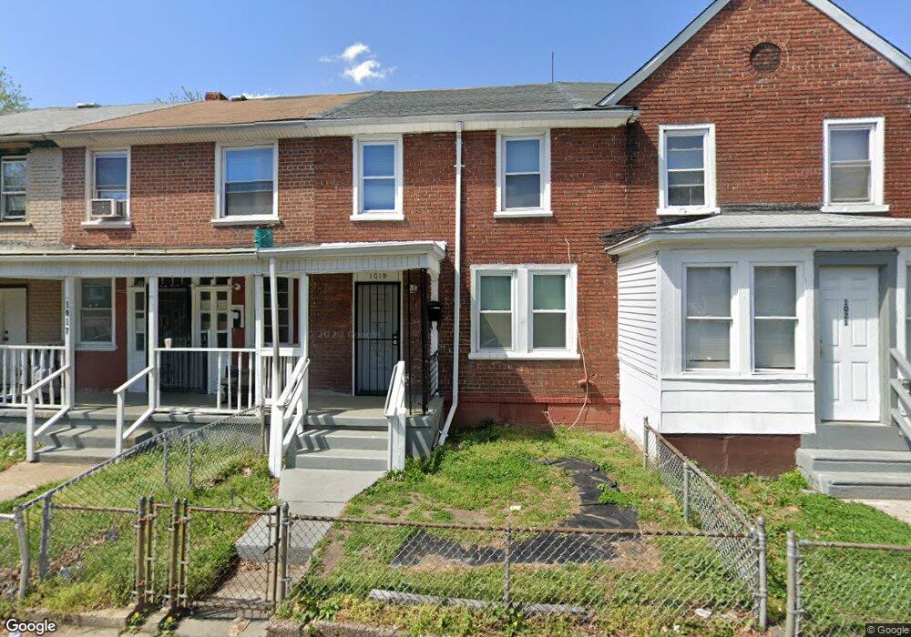
1019 Monitor Rd Camden, NJ 08104
Fairview NeighborhoodEstimated Value: $122,000 - $145,000
3
Beds
1
Bath
904
Sq Ft
$145/Sq Ft
Est. Value
About This Home
This home is located at 1019 Monitor Rd, Camden, NJ 08104 and is currently estimated at $130,987, approximately $144 per square foot. 1019 Monitor Rd is a home located in Camden County with nearby schools including Yorkship Elementary School, Camden High School, and Sacred Heart School.
Ownership History
Date
Name
Owned For
Owner Type
Purchase Details
Closed on
Sep 16, 2016
Sold by
Gee Mary and Gee Mary A
Bought by
Real Portfolio 4 Llc
Current Estimated Value
Home Financials for this Owner
Home Financials are based on the most recent Mortgage that was taken out on this home.
Original Mortgage
$276,674
Outstanding Balance
$221,209
Interest Rate
3.46%
Mortgage Type
Commercial
Estimated Equity
-$90,222
Purchase Details
Closed on
Feb 12, 2002
Sold by
Tompkins Michael
Bought by
James James F
Home Financials for this Owner
Home Financials are based on the most recent Mortgage that was taken out on this home.
Original Mortgage
$35,000
Interest Rate
6.85%
Purchase Details
Closed on
Sep 29, 1993
Sold by
Margerum Annee
Bought by
Thompkins Michael
Create a Home Valuation Report for This Property
The Home Valuation Report is an in-depth analysis detailing your home's value as well as a comparison with similar homes in the area
Home Values in the Area
Average Home Value in this Area
Purchase History
| Date | Buyer | Sale Price | Title Company |
|---|---|---|---|
| Real Portfolio 4 Llc | $343,637 | Infinity Title Agency | |
| James James F | $35,000 | -- | |
| Thompkins Michael | $27,500 | -- |
Source: Public Records
Mortgage History
| Date | Status | Borrower | Loan Amount |
|---|---|---|---|
| Open | Real Portfolio 4 Llc | $276,674 | |
| Previous Owner | James James F | $35,000 |
Source: Public Records
Tax History Compared to Growth
Tax History
| Year | Tax Paid | Tax Assessment Tax Assessment Total Assessment is a certain percentage of the fair market value that is determined by local assessors to be the total taxable value of land and additions on the property. | Land | Improvement |
|---|---|---|---|---|
| 2025 | $1,772 | $50,000 | $13,800 | $36,200 |
| 2024 | $1,713 | $50,000 | $13,800 | $36,200 |
| 2023 | $1,713 | $50,000 | $13,800 | $36,200 |
| 2022 | $1,681 | $50,000 | $13,800 | $36,200 |
| 2021 | $1,675 | $50,000 | $13,800 | $36,200 |
| 2020 | $1,590 | $50,000 | $13,800 | $36,200 |
| 2019 | $1,523 | $50,000 | $13,800 | $36,200 |
| 2018 | $1,515 | $50,000 | $13,800 | $36,200 |
| 2017 | $1,478 | $50,000 | $13,800 | $36,200 |
| 2016 | $1,431 | $50,000 | $13,800 | $36,200 |
| 2015 | $1,377 | $50,000 | $13,800 | $36,200 |
| 2014 | $1,344 | $50,000 | $13,800 | $36,200 |
Source: Public Records
Map
Nearby Homes
- 1029 Ironside Rd
- 1020 Niagara Rd
- 1065 Ironside Rd
- 3159 W Ironside Rd
- 1072 S Merrimac Rd
- 3044 Fenwick Rd
- 1261 S Merrimac Rd
- 2909 Yorkship Rd
- 2870 Kansas Rd
- 3069 S Chesapeake Rd
- 2845 N Constitution Rd
- 1300 S Merrimac Rd
- 3079 Alabama Rd
- 2828 Yorkship Rd Unit 1
- 1316 S Merrimac Rd
- 1333 Argus Rd
- 2682 N Congress Rd
- 2931 N Constitution Rd
- 1433 N Chesapeake Rd
- 607 N Johnson Blvd
- 1017 Monitor Rd
- 1021 Monitor Rd
- 1015 Monitor Rd
- 1023 Monitor Rd
- 1013 Monitor Rd
- 1025 Monitor Rd
- 1011 Monitor Rd
- 1027 Monitor Rd
- 1026 Ironside Rd
- 1028 Ironside Rd
- 1024 Ironside Rd
- 1030 Ironside Rd
- 1032 Ironside Rd
- 1016 Ironside Rd
- 1018 Monitor Rd
- 1016 Monitor Rd
- 1014 Ironside Rd
- 1020 Monitor Rd
- 1014 Monitor Rd
- 3105 Sumter Rd